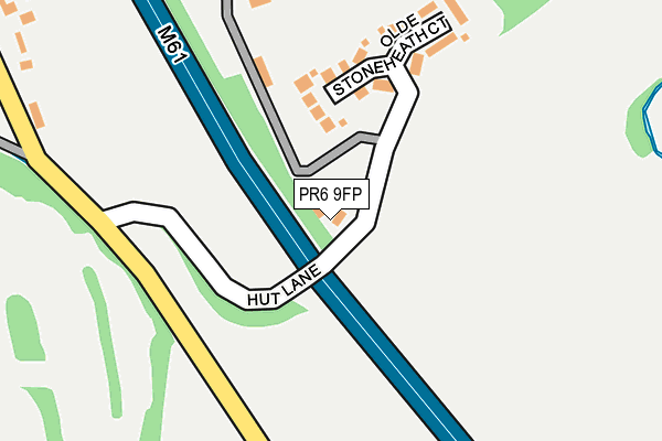
PR6 9FP is located in the Chorley South East & Heath Charnock electoral ward, within the local authority district of Chorley and the English Parliamentary constituency of Chorley. The Sub Integrated Care Board (ICB) Location is NHS Lancashire and South Cumbria ICB - 00X and the police force is Lancashire. This postcode has been in use since July 2009.


GetTheData
Source: OS OpenMap – Local (Ordnance Survey)
Source: OS VectorMap District (Ordnance Survey)
Licence: Open Government Licence (requires attribution)
| Easting | 360852 |
| Northing | 415508 |
| Latitude | 53.634636 |
| Longitude | -2.593513 |
GetTheData
Source: Open Postcode Geo
Licence: Open Government Licence
| Country | England |
| Postcode District | PR6 |
➜ See where PR6 is on a map | |
GetTheData
Source: Land Registry Price Paid Data
Licence: Open Government Licence
Elevation or altitude of PR6 9FP as distance above sea level:
| Metres | Feet | |
|---|---|---|
| Elevation | 130m | 427ft |
Elevation is measured from the approximate centre of the postcode, to the nearest point on an OS contour line from OS Terrain 50, which has contour spacing of ten vertical metres.
➜ How high above sea level am I? Find the elevation of your current position using your device's GPS.
GetTheData
Source: Open Postcode Elevation
Licence: Open Government Licence
| Ward | Chorley South East & Heath Charnock |
| Constituency | Chorley |
GetTheData
Source: ONS Postcode Database
Licence: Open Government Licence
| Hut Lane (Long Lane) | Limbrick | 196m |
| Hut Lane (Long Lane) | Limbrick | 213m |
| Bay Horse (Long Lane) | Adlington | 1,009m |
| Bay Horse (Long Lane) | Adlington | 1,018m |
| Cricket Club (Long Lane) | Limbrick | 1,142m |
| Adlington (Lancs) Station | 2.5km |
| Chorley Station | 3km |
| Blackrod Station | 5.1km |
GetTheData
Source: NaPTAN
Licence: Open Government Licence
GetTheData
Source: ONS Postcode Database
Licence: Open Government Licence


➜ Get more ratings from the Food Standards Agency
GetTheData
Source: Food Standards Agency
Licence: FSA terms & conditions
| Last Collection | |||
|---|---|---|---|
| Location | Mon-Fri | Sat | Distance |
| Limbrick | 16:30 | 10:30 | 1,134m |
| Bolton Road, Duxbury | 17:15 | 11:00 | 1,356m |
| Weldbank Lane | 16:45 | 11:30 | 1,875m |
GetTheData
Source: Dracos
Licence: Creative Commons Attribution-ShareAlike
The below table lists the International Territorial Level (ITL) codes (formerly Nomenclature of Territorial Units for Statistics (NUTS) codes) and Local Administrative Units (LAU) codes for PR6 9FP:
| ITL 1 Code | Name |
|---|---|
| TLD | North West (England) |
| ITL 2 Code | Name |
| TLD4 | Lancashire |
| ITL 3 Code | Name |
| TLD47 | Chorley and West Lancashire |
| LAU 1 Code | Name |
| E07000118 | Chorley |
GetTheData
Source: ONS Postcode Directory
Licence: Open Government Licence
The below table lists the Census Output Area (OA), Lower Layer Super Output Area (LSOA), and Middle Layer Super Output Area (MSOA) for PR6 9FP:
| Code | Name | |
|---|---|---|
| OA | E00126752 | |
| LSOA | E01024973 | Chorley 014E |
| MSOA | E02005202 | Chorley 014 |
GetTheData
Source: ONS Postcode Directory
Licence: Open Government Licence
| PR6 9EH | Olde Stoneheath Court | 153m |
| PR6 9EG | Long Lane | 231m |
| PR6 9EF | Long Lane | 341m |
| PR6 9EQ | Long Lane | 544m |
| PR6 9EJ | Slacks Lane | 669m |
| PR6 9EZ | Brickfield Cottages | 813m |
| PR6 9HB | Back Lane | 829m |
| PR6 9DW | Back Lane | 848m |
| PR6 9HA | Broad Oak Cottages | 870m |
| PR6 9EP | Nickleton Brow | 917m |
GetTheData
Source: Open Postcode Geo; Land Registry Price Paid Data
Licence: Open Government Licence