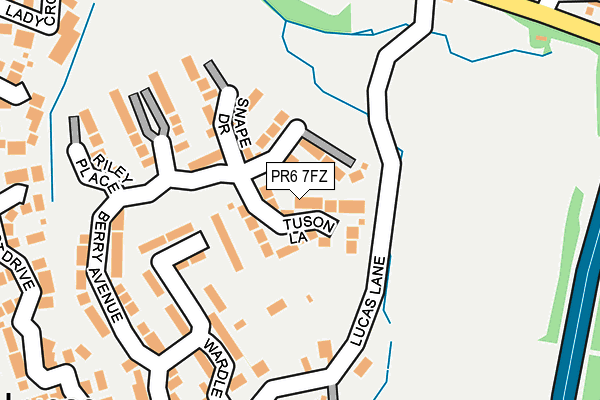
PR6 7FZ is located in the Chorley North East electoral ward, within the local authority district of Chorley and the English Parliamentary constituency of Chorley. The Sub Integrated Care Board (ICB) Location is NHS Lancashire and South Cumbria ICB - 00X and the police force is Lancashire. This postcode has been in use since June 2017.


GetTheData
Source: OS OpenMap – Local (Ordnance Survey)
Source: OS VectorMap District (Ordnance Survey)
Licence: Open Government Licence (requires attribution)
| Easting | 358377 |
| Northing | 420759 |
| Latitude | 53.681639 |
| Longitude | -2.631645 |
GetTheData
Source: Open Postcode Geo
Licence: Open Government Licence
| Country | England |
| Postcode District | PR6 |
➜ See where PR6 is on a map ➜ Where is Whittle-le-Woods? | |
GetTheData
Source: Land Registry Price Paid Data
Licence: Open Government Licence
| Ward | Chorley North East |
| Constituency | Chorley |
GetTheData
Source: ONS Postcode Database
Licence: Open Government Licence
| Hardacre Lane (Preston Road) | Whittle-le-woods | 377m |
| Hardacre Lane (Preston Road) | Whittle-le-woods | 422m |
| Shaw Brow | Whittle-le-woods | 466m |
| Shaw Hill Golf Club (Preston Road) | Whittle-le-woods | 490m |
| Shaw Hill Golf Club (Preston Road) | Whittle-le-woods | 529m |
| Buckshaw Parkway Station | 2.1km |
| Chorley Station | 3.3km |
| Euxton Balshaw Lane Station | 3.6km |
GetTheData
Source: NaPTAN
Licence: Open Government Licence
| Percentage of properties with Next Generation Access | 100.0% |
| Percentage of properties with Superfast Broadband | 100.0% |
| Percentage of properties with Ultrafast Broadband | 100.0% |
| Percentage of properties with Full Fibre Broadband | 100.0% |
Superfast Broadband is between 30Mbps and 300Mbps
Ultrafast Broadband is > 300Mbps
| Percentage of properties unable to receive 2Mbps | 0.0% |
| Percentage of properties unable to receive 5Mbps | 0.0% |
| Percentage of properties unable to receive 10Mbps | 0.0% |
| Percentage of properties unable to receive 30Mbps | 0.0% |
GetTheData
Source: Ofcom
Licence: Ofcom Terms of Use (requires attribution)
GetTheData
Source: ONS Postcode Database
Licence: Open Government Licence


➜ Get more ratings from the Food Standards Agency
GetTheData
Source: Food Standards Agency
Licence: FSA terms & conditions
| Last Collection | |||
|---|---|---|---|
| Location | Mon-Fri | Sat | Distance |
| Swansey | 17:15 | 10:45 | 435m |
| Highfield Road North | 16:45 | 11:30 | 2,022m |
| 88 Hamilton Road | 17:15 | 11:30 | 2,342m |
GetTheData
Source: Dracos
Licence: Creative Commons Attribution-ShareAlike
The below table lists the International Territorial Level (ITL) codes (formerly Nomenclature of Territorial Units for Statistics (NUTS) codes) and Local Administrative Units (LAU) codes for PR6 7FZ:
| ITL 1 Code | Name |
|---|---|
| TLD | North West (England) |
| ITL 2 Code | Name |
| TLD4 | Lancashire |
| ITL 3 Code | Name |
| TLD47 | Chorley and West Lancashire |
| LAU 1 Code | Name |
| E07000118 | Chorley |
GetTheData
Source: ONS Postcode Directory
Licence: Open Government Licence
The below table lists the Census Output Area (OA), Lower Layer Super Output Area (LSOA), and Middle Layer Super Output Area (MSOA) for PR6 7FZ:
| Code | Name | |
|---|---|---|
| OA | E00126773 | |
| LSOA | E01024977 | Chorley 004D |
| MSOA | E02005192 | Chorley 004 |
GetTheData
Source: ONS Postcode Directory
Licence: Open Government Licence
| PR6 7FX | Berry Avenue | 134m |
| PR6 7DA | Lucas Lane | 142m |
| PR6 7DN | Dunham Drive | 149m |
| PR6 7DQ | Wardle Court | 163m |
| PR6 7GY | Buckton Close | 200m |
| PR6 7FW | Magill Close | 206m |
| PR6 7FU | Riley Place | 229m |
| PR6 7GX | Mottram Close | 281m |
| PR6 7DH | Town Lane | 281m |
| PR6 7QN | Farm House Close | 286m |
GetTheData
Source: Open Postcode Geo; Land Registry Price Paid Data
Licence: Open Government Licence