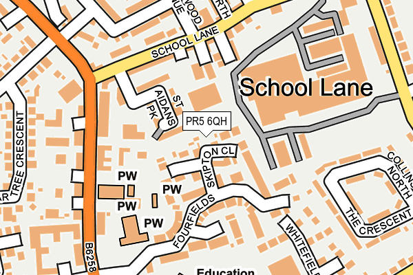
PR5 6QH is located in the Bamber Bridge East electoral ward, within the local authority district of South Ribble and the English Parliamentary constituency of Ribble Valley. The Sub Integrated Care Board (ICB) Location is NHS Lancashire and South Cumbria ICB - 00X and the police force is Lancashire. This postcode has been in use since May 2017.


GetTheData
Source: OS OpenMap – Local (Ordnance Survey)
Source: OS VectorMap District (Ordnance Survey)
Licence: Open Government Licence (requires attribution)
| Easting | 356508 |
| Northing | 426832 |
| Latitude | 53.736067 |
| Longitude | -2.660795 |
GetTheData
Source: Open Postcode Geo
Licence: Open Government Licence
| Country | England |
| Postcode District | PR5 |
➜ See where PR5 is on a map ➜ Where is Bamber Bridge? | |
GetTheData
Source: Land Registry Price Paid Data
Licence: Open Government Licence
| Ward | Bamber Bridge East |
| Constituency | Ribble Valley |
GetTheData
Source: ONS Postcode Database
Licence: Open Government Licence
| School Lane Garage (School Lane) | Bamber Bridge | 54m |
| School Lane Garage (School Lane) | Bamber Bridge | 62m |
| School Lane Nursery (School Lane) | Bamber Bridge | 163m |
| School Lane Nursery (School Lane) | Bamber Bridge | 175m |
| Renshaw Drive (Chorley Road) | Bamber Bridge | 207m |
| Bamber Bridge Station | 1km |
| Lostock Hall Station | 2.2km |
| Preston Station | 3.9km |
GetTheData
Source: NaPTAN
Licence: Open Government Licence
GetTheData
Source: ONS Postcode Database
Licence: Open Government Licence


➜ Get more ratings from the Food Standards Agency
GetTheData
Source: Food Standards Agency
Licence: FSA terms & conditions
| Last Collection | |||
|---|---|---|---|
| Location | Mon-Fri | Sat | Distance |
| 88 Brindle Road, Bamber Bridge | 16:00 | 11:00 | 472m |
| Withy Trees | 16:15 | 09:00 | 565m |
| Hampshire Road, Walton Le Dale | 16:00 | 09:00 | 582m |
GetTheData
Source: Dracos
Licence: Creative Commons Attribution-ShareAlike
The below table lists the International Territorial Level (ITL) codes (formerly Nomenclature of Territorial Units for Statistics (NUTS) codes) and Local Administrative Units (LAU) codes for PR5 6QH:
| ITL 1 Code | Name |
|---|---|
| TLD | North West (England) |
| ITL 2 Code | Name |
| TLD4 | Lancashire |
| ITL 3 Code | Name |
| TLD45 | Mid Lancashire |
| LAU 1 Code | Name |
| E07000126 | South Ribble |
GetTheData
Source: ONS Postcode Directory
Licence: Open Government Licence
The below table lists the Census Output Area (OA), Lower Layer Super Output Area (LSOA), and Middle Layer Super Output Area (MSOA) for PR5 6QH:
| Code | Name | |
|---|---|---|
| OA | E00128923 | |
| LSOA | E01025402 | South Ribble 008D |
| MSOA | E02005294 | South Ribble 008 |
GetTheData
Source: ONS Postcode Directory
Licence: Open Government Licence
| PR5 6QD | School Lane | 51m |
| PR5 6QE | School Lane | 67m |
| PR5 6GE | Ashworth Street | 71m |
| PR5 6HG | St Aidans Park | 84m |
| PR5 6QA | Brandiforth Street | 102m |
| PR5 6GA | Brandiforth Street | 127m |
| PR5 6DE | Pearwood Close | 138m |
| PR5 6QB | School Street | 142m |
| PR5 6DT | Walnutwood Avenue | 154m |
| PR5 6BW | Alderwood Road | 160m |
GetTheData
Source: Open Postcode Geo; Land Registry Price Paid Data
Licence: Open Government Licence