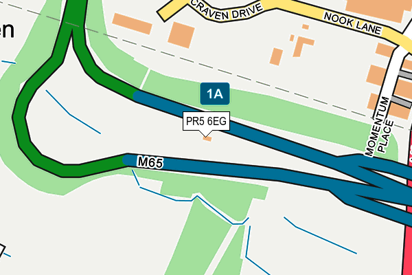
PR5 6EG is located in the Farington East electoral ward, within the local authority district of South Ribble and the English Parliamentary constituency of Ribble Valley. The Sub Integrated Care Board (ICB) Location is NHS Lancashire and South Cumbria ICB - 00X and the police force is Lancashire. This postcode has been in use since February 2016.


GetTheData
Source: OS OpenMap – Local (Ordnance Survey)
Source: OS VectorMap District (Ordnance Survey)
Licence: Open Government Licence (requires attribution)
| Easting | 355765 |
| Northing | 424783 |
| Latitude | 53.717573 |
| Longitude | -2.671767 |
GetTheData
Source: Open Postcode Geo
Licence: Open Government Licence
| Country | England |
| Postcode District | PR5 |
➜ See where PR5 is on a map | |
GetTheData
Source: Land Registry Price Paid Data
Licence: Open Government Licence
Elevation or altitude of PR5 6EG as distance above sea level:
| Metres | Feet | |
|---|---|---|
| Elevation | 50m | 164ft |
Elevation is measured from the approximate centre of the postcode, to the nearest point on an OS contour line from OS Terrain 50, which has contour spacing of ten vertical metres.
➜ How high above sea level am I? Find the elevation of your current position using your device's GPS.
GetTheData
Source: Open Postcode Elevation
Licence: Open Government Licence
| Ward | Farington East |
| Constituency | Ribble Valley |
GetTheData
Source: ONS Postcode Database
Licence: Open Government Licence
| Sainsburys (Cuerden Way) | Bamber Bridge | 532m |
| Hob Inn Turning Circle (Church Road) | Bamber Bridge | 729m |
| Woodcock Farm (Stanifield Lane) | Farington | 741m |
| Brook House Farm (Stanifield Lane) | Farington | 747m |
| Woodcock Farm (Stanifield Lane) | Farington | 750m |
| Bamber Bridge Station | 1.3km |
| Lostock Hall Station | 1.3km |
| Leyland Station | 2.3km |
GetTheData
Source: NaPTAN
Licence: Open Government Licence
GetTheData
Source: ONS Postcode Database
Licence: Open Government Licence


➜ Get more ratings from the Food Standards Agency
GetTheData
Source: Food Standards Agency
Licence: FSA terms & conditions
| Last Collection | |||
|---|---|---|---|
| Location | Mon-Fri | Sat | Distance |
| Dewhurst Row | 16:15 | 10:30 | 497m |
| Walton Summit (2) | 18:30 | 1,285m | |
| Walton Summit (2) | 17:30 | 09:00 | 1,290m |
GetTheData
Source: Dracos
Licence: Creative Commons Attribution-ShareAlike
The below table lists the International Territorial Level (ITL) codes (formerly Nomenclature of Territorial Units for Statistics (NUTS) codes) and Local Administrative Units (LAU) codes for PR5 6EG:
| ITL 1 Code | Name |
|---|---|
| TLD | North West (England) |
| ITL 2 Code | Name |
| TLD4 | Lancashire |
| ITL 3 Code | Name |
| TLD45 | Mid Lancashire |
| LAU 1 Code | Name |
| E07000126 | South Ribble |
GetTheData
Source: ONS Postcode Directory
Licence: Open Government Licence
The below table lists the Census Output Area (OA), Lower Layer Super Output Area (LSOA), and Middle Layer Super Output Area (MSOA) for PR5 6EG:
| Code | Name | |
|---|---|---|
| OA | E00128995 | |
| LSOA | E01025417 | South Ribble 012A |
| MSOA | E02005298 | South Ribble 012 |
GetTheData
Source: ONS Postcode Directory
Licence: Open Government Licence
| PR5 6EF | Momentum Place | 286m |
| PR5 6AS | Wigan Road | 421m |
| PR5 5XP | Old School Lane | 573m |
| PR5 5XQ | Stoney Lane | 575m |
| PR5 6ES | Riverside | 653m |
| PR5 6BB | Dewhurst Row | 691m |
| PR5 5XU | Lostock Lane | 727m |
| PR5 6ER | Havelock Road | 748m |
| PR5 5BF | Tudor Croft | 749m |
| PR5 5BG | Regency Avenue | 761m |
GetTheData
Source: Open Postcode Geo; Land Registry Price Paid Data
Licence: Open Government Licence