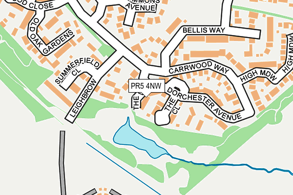
PR5 4NW lies on The Vale in Walton Le Dale, Preston. PR5 4NW is located in the Walton-le-Dale West electoral ward, within the local authority district of South Ribble and the English Parliamentary constituency of Ribble Valley. The Sub Integrated Care Board (ICB) Location is NHS Lancashire and South Cumbria ICB - 00X and the police force is Lancashire. This postcode has been in use since January 2006.


GetTheData
Source: OS OpenMap – Local (Ordnance Survey)
Source: OS VectorMap District (Ordnance Survey)
Licence: Open Government Licence (requires attribution)
| Easting | 354731 |
| Northing | 426827 |
| Latitude | 53.735854 |
| Longitude | -2.687733 |
GetTheData
Source: Open Postcode Geo
Licence: Open Government Licence
| Street | The Vale |
| Locality | Walton Le Dale |
| Town/City | Preston |
| Country | England |
| Postcode District | PR5 |
➜ See where PR5 is on a map ➜ Where is Bamber Bridge? | |
GetTheData
Source: Land Registry Price Paid Data
Licence: Open Government Licence
Elevation or altitude of PR5 4NW as distance above sea level:
| Metres | Feet | |
|---|---|---|
| Elevation | 30m | 98ft |
Elevation is measured from the approximate centre of the postcode, to the nearest point on an OS contour line from OS Terrain 50, which has contour spacing of ten vertical metres.
➜ How high above sea level am I? Find the elevation of your current position using your device's GPS.
GetTheData
Source: Open Postcode Elevation
Licence: Open Government Licence
| Ward | Walton-le-dale West |
| Constituency | Ribble Valley |
GetTheData
Source: ONS Postcode Database
Licence: Open Government Licence
3, THE VALE, WALTON LE DALE, PRESTON, PR5 4NW 2020 15 DEC £314,000 |
4, THE VALE, WALTON LE DALE, PRESTON, PR5 4NW 2016 10 OCT £400,000 |
2, THE VALE, WALTON LE DALE, PRESTON, PR5 4NW 2015 17 JUL £227,500 |
4, THE VALE, WALTON LE DALE, PRESTON, PR5 4NW 2008 25 JUN £374,500 |
2, THE VALE, WALTON LE DALE, PRESTON, PR5 4NW 2008 12 JUN £224,500 |
3, THE VALE, WALTON LE DALE, PRESTON, PR5 4NW 2008 29 MAY £255,500 |
GetTheData
Source: HM Land Registry Price Paid Data
Licence: Contains HM Land Registry data © Crown copyright and database right 2025. This data is licensed under the Open Government Licence v3.0.
| Hennel Lane (Millwood Road) | Walton Park | 410m |
| Hennel Lane (Millwood Road) | Walton Park | 410m |
| Carrwood Roundabout (Carrwood Road) | Walton Park | 429m |
| Lyndale Avenue (Todd Lane North) | Lostock Hall | 447m |
| Millwood Road | Walton Park | 448m |
| Lostock Hall Station | 1.3km |
| Bamber Bridge Station | 2km |
| Preston Station | 2.7km |
GetTheData
Source: NaPTAN
Licence: Open Government Licence
| Percentage of properties with Next Generation Access | 100.0% |
| Percentage of properties with Superfast Broadband | 100.0% |
| Percentage of properties with Ultrafast Broadband | 0.0% |
| Percentage of properties with Full Fibre Broadband | 0.0% |
Superfast Broadband is between 30Mbps and 300Mbps
Ultrafast Broadband is > 300Mbps
| Percentage of properties unable to receive 2Mbps | 0.0% |
| Percentage of properties unable to receive 5Mbps | 0.0% |
| Percentage of properties unable to receive 10Mbps | 0.0% |
| Percentage of properties unable to receive 30Mbps | 0.0% |
GetTheData
Source: Ofcom
Licence: Ofcom Terms of Use (requires attribution)
GetTheData
Source: ONS Postcode Database
Licence: Open Government Licence


➜ Get more ratings from the Food Standards Agency
GetTheData
Source: Food Standards Agency
Licence: FSA terms & conditions
| Last Collection | |||
|---|---|---|---|
| Location | Mon-Fri | Sat | Distance |
| 109 Todd Lane North | 16:00 | 09:00 | 451m |
| Doultons | 16:00 | 09:00 | 530m |
| The Cawsey | 16:45 | 11:30 | 713m |
GetTheData
Source: Dracos
Licence: Creative Commons Attribution-ShareAlike
The below table lists the International Territorial Level (ITL) codes (formerly Nomenclature of Territorial Units for Statistics (NUTS) codes) and Local Administrative Units (LAU) codes for PR5 4NW:
| ITL 1 Code | Name |
|---|---|
| TLD | North West (England) |
| ITL 2 Code | Name |
| TLD4 | Lancashire |
| ITL 3 Code | Name |
| TLD45 | Mid Lancashire |
| LAU 1 Code | Name |
| E07000126 | South Ribble |
GetTheData
Source: ONS Postcode Directory
Licence: Open Government Licence
The below table lists the Census Output Area (OA), Lower Layer Super Output Area (LSOA), and Middle Layer Super Output Area (MSOA) for PR5 4NW:
| Code | Name | |
|---|---|---|
| OA | E00168802 | |
| LSOA | E01025461 | South Ribble 009D |
| MSOA | E02005295 | South Ribble 009 |
GetTheData
Source: ONS Postcode Directory
Licence: Open Government Licence
| PR5 4DG | Leigh Meadows | 49m |
| PR5 4NZ | The Close | 64m |
| PR5 5UJ | Hennel Lane | 65m |
| PR5 5QZ | Leigh Brow | 106m |
| PR5 4PE | Dorchester Avenue | 106m |
| PR5 4NY | The Boulevard | 121m |
| PR5 4NR | Carrwood Way | 153m |
| PR5 4NP | Summerfield Close | 159m |
| PR5 4NS | Bellis Way | 185m |
| PR5 4LX | Simmons Avenue | 189m |
GetTheData
Source: Open Postcode Geo; Land Registry Price Paid Data
Licence: Open Government Licence