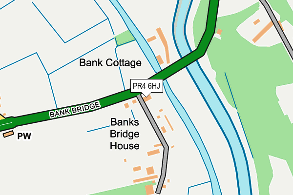
PR4 6HJ lies on Bank Bridge in Tarleton, Preston. PR4 6HJ is located in the Tarleton Village electoral ward, within the local authority district of West Lancashire and the English Parliamentary constituency of South Ribble. The Sub Integrated Care Board (ICB) Location is NHS Lancashire and South Cumbria ICB - 02G and the police force is Lancashire. This postcode has been in use since January 1980.


GetTheData
Source: OS OpenMap – Local (Ordnance Survey)
Source: OS VectorMap District (Ordnance Survey)
Licence: Open Government Licence (requires attribution)
| Easting | 345949 |
| Northing | 420198 |
| Latitude | 53.675456 |
| Longitude | -2.819690 |
GetTheData
Source: Open Postcode Geo
Licence: Open Government Licence
| Street | Bank Bridge |
| Locality | Tarleton |
| Town/City | Preston |
| Country | England |
| Postcode District | PR4 |
➜ See where PR4 is on a map | |
GetTheData
Source: Land Registry Price Paid Data
Licence: Open Government Licence
Elevation or altitude of PR4 6HJ as distance above sea level:
| Metres | Feet | |
|---|---|---|
| Elevation | 10m | 33ft |
Elevation is measured from the approximate centre of the postcode, to the nearest point on an OS contour line from OS Terrain 50, which has contour spacing of ten vertical metres.
➜ How high above sea level am I? Find the elevation of your current position using your device's GPS.
GetTheData
Source: Open Postcode Elevation
Licence: Open Government Licence
| Ward | Tarleton Village |
| Constituency | South Ribble |
GetTheData
Source: ONS Postcode Database
Licence: Open Government Licence
| Coe Lane | Tarleton | 318m |
| Meadoway/Coe Lane (Coe Lane) | Tarleton | 356m |
| Meadoway (Coe Lane) | Tarleton | 538m |
| Windgate | Tarleton | 609m |
| Windgate | Tarleton | 609m |
| Croston Station | 2.9km |
| Rufford Station | 4.6km |
GetTheData
Source: NaPTAN
Licence: Open Government Licence
| Percentage of properties with Next Generation Access | 60.0% |
| Percentage of properties with Superfast Broadband | 60.0% |
| Percentage of properties with Ultrafast Broadband | 60.0% |
| Percentage of properties with Full Fibre Broadband | 60.0% |
Superfast Broadband is between 30Mbps and 300Mbps
Ultrafast Broadband is > 300Mbps
| Percentage of properties unable to receive 2Mbps | 0.0% |
| Percentage of properties unable to receive 5Mbps | 0.0% |
| Percentage of properties unable to receive 10Mbps | 0.0% |
| Percentage of properties unable to receive 30Mbps | 40.0% |
GetTheData
Source: Ofcom
Licence: Ofcom Terms of Use (requires attribution)
GetTheData
Source: ONS Postcode Database
Licence: Open Government Licence


➜ Get more ratings from the Food Standards Agency
GetTheData
Source: Food Standards Agency
Licence: FSA terms & conditions
| Last Collection | |||
|---|---|---|---|
| Location | Mon-Fri | Sat | Distance |
| Hesketh Lane Post Office | 17:30 | 12:00 | 1,579m |
| Lock House | 16:00 | 10:30 | 1,746m |
| Old Bretherton Post Office | 16:45 | 11:00 | 2,076m |
GetTheData
Source: Dracos
Licence: Creative Commons Attribution-ShareAlike
The below table lists the International Territorial Level (ITL) codes (formerly Nomenclature of Territorial Units for Statistics (NUTS) codes) and Local Administrative Units (LAU) codes for PR4 6HJ:
| ITL 1 Code | Name |
|---|---|
| TLD | North West (England) |
| ITL 2 Code | Name |
| TLD4 | Lancashire |
| ITL 3 Code | Name |
| TLD47 | Chorley and West Lancashire |
| LAU 1 Code | Name |
| E07000127 | West Lancashire |
GetTheData
Source: ONS Postcode Directory
Licence: Open Government Licence
The below table lists the Census Output Area (OA), Lower Layer Super Output Area (LSOA), and Middle Layer Super Output Area (MSOA) for PR4 6HJ:
| Code | Name | |
|---|---|---|
| OA | E00129567 | |
| LSOA | E01025533 | West Lancashire 001F |
| MSOA | E02005304 | West Lancashire 001 |
GetTheData
Source: ONS Postcode Directory
Licence: Open Government Licence
| PR26 9AT | 338m | |
| PR4 6NB | St Helens Well | 413m |
| PR4 6NE | Edward Close | 526m |
| PR4 6NH | Pond Close | 538m |
| PR4 6NL | Parsonage Gardens | 546m |
| PR4 6HH | Coe Lane | 561m |
| PR4 6NA | Meadoway | 579m |
| PR4 6NG | Rectory Gardens | 580m |
| PR26 9AX | Liverpool Road | 618m |
| PR4 6NJ | Lilford Close | 623m |
GetTheData
Source: Open Postcode Geo; Land Registry Price Paid Data
Licence: Open Government Licence