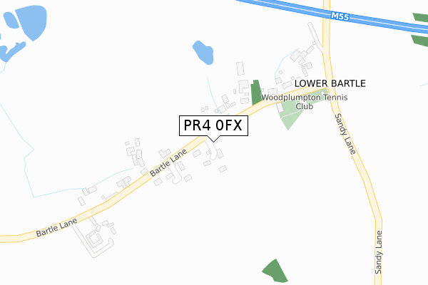
PR4 0FX is located in the Preston Rural North electoral ward, within the local authority district of Preston and the English Parliamentary constituency of Wyre and Preston North. The Sub Integrated Care Board (ICB) Location is NHS Lancashire and South Cumbria ICB - 01E and the police force is Lancashire. This postcode has been in use since April 2020.


GetTheData
Source: OS Open Zoomstack (Ordnance Survey)
Licence: Open Government Licence (requires attribution)
Attribution: Contains OS data © Crown copyright and database right 2025
Source: Open Postcode Geo
Licence: Open Government Licence (requires attribution)
Attribution: Contains OS data © Crown copyright and database right 2025; Contains Royal Mail data © Royal Mail copyright and database right 2025; Source: Office for National Statistics licensed under the Open Government Licence v.3.0
| Easting | 349501 |
| Northing | 433546 |
| Latitude | 53.795774 |
| Longitude | -2.768109 |
GetTheData
Source: Open Postcode Geo
Licence: Open Government Licence
| Country | England |
| Postcode District | PR4 |
➜ See where PR4 is on a map ➜ Where is Lower Bartle? | |
GetTheData
Source: Land Registry Price Paid Data
Licence: Open Government Licence
| Ward | Preston Rural North |
| Constituency | Wyre And Preston North |
GetTheData
Source: ONS Postcode Database
Licence: Open Government Licence
| Sandy Lane | Lower Bartle | 301m |
| Wheatsheaf (Woodplumpton Road) | Woodplumpton | 1,044m |
| Wheatsheaf (Woodplumpton Road) | Woodplumpton | 1,048m |
| Sitting Goose (Sidgreaves Lane) | Lower Bartle | 1,060m |
| Sitting Goose (Sidgreaves Lane) | Lower Bartle | 1,078m |
| Salwick Station | 3.6km |
| Preston Station | 5.9km |
GetTheData
Source: NaPTAN
Licence: Open Government Licence
GetTheData
Source: ONS Postcode Database
Licence: Open Government Licence


➜ Get more ratings from the Food Standards Agency
GetTheData
Source: Food Standards Agency
Licence: FSA terms & conditions
| Last Collection | |||
|---|---|---|---|
| Location | Mon-Fri | Sat | Distance |
| Whitehouse | 16:00 | 08:30 | 1,165m |
| Nog Tow | 16:00 | 10:30 | 1,237m |
| Lea School | 16:00 | 08:00 | 1,684m |
GetTheData
Source: Dracos
Licence: Creative Commons Attribution-ShareAlike
The below table lists the International Territorial Level (ITL) codes (formerly Nomenclature of Territorial Units for Statistics (NUTS) codes) and Local Administrative Units (LAU) codes for PR4 0FX:
| ITL 1 Code | Name |
|---|---|
| TLD | North West (England) |
| ITL 2 Code | Name |
| TLD4 | Lancashire |
| ITL 3 Code | Name |
| TLD45 | Mid Lancashire |
| LAU 1 Code | Name |
| E07000123 | Preston |
GetTheData
Source: ONS Postcode Directory
Licence: Open Government Licence
The below table lists the Census Output Area (OA), Lower Layer Super Output Area (LSOA), and Middle Layer Super Output Area (MSOA) for PR4 0FX:
| Code | Name | |
|---|---|---|
| OA | E00128320 | |
| LSOA | E01025280 | Preston 002C |
| MSOA | E02005254 | Preston 002 |
GetTheData
Source: ONS Postcode Directory
Licence: Open Government Licence
| PR4 0RU | 221m | |
| PR4 0RR | 366m | |
| PR4 0RX | Sandy Lane | 542m |
| PR4 0LH | Tabley Lane | 833m |
| PR4 0LE | Sandy Lane | 955m |
| PR4 0HA | Lea Lane | 1027m |
| PR4 0WE | The Orchard | 1073m |
| PR4 0NB | Hoyles Lane | 1101m |
| PR4 0WB | The Granings | 1107m |
| PR4 0NE | Woodplumpton Road | 1132m |
GetTheData
Source: Open Postcode Geo; Land Registry Price Paid Data
Licence: Open Government Licence