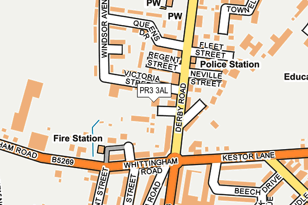
PR3 3AL is located in the Derby & Thornley electoral ward, within the local authority district of Ribble Valley and the English Parliamentary constituency of Ribble Valley. The Sub Integrated Care Board (ICB) Location is NHS Lancashire and South Cumbria ICB - 01E and the police force is Lancashire. This postcode has been in use since January 1980.


GetTheData
Source: OS OpenMap – Local (Ordnance Survey)
Source: OS VectorMap District (Ordnance Survey)
Licence: Open Government Licence (requires attribution)
| Easting | 360062 |
| Northing | 437234 |
| Latitude | 53.829823 |
| Longitude | -2.608275 |
GetTheData
Source: Open Postcode Geo
Licence: Open Government Licence
| Country | England |
| Postcode District | PR3 |
➜ See where PR3 is on a map ➜ Where is Longridge? | |
GetTheData
Source: Land Registry Price Paid Data
Licence: Open Government Licence
Elevation or altitude of PR3 3AL as distance above sea level:
| Metres | Feet | |
|---|---|---|
| Elevation | 110m | 361ft |
Elevation is measured from the approximate centre of the postcode, to the nearest point on an OS contour line from OS Terrain 50, which has contour spacing of ten vertical metres.
➜ How high above sea level am I? Find the elevation of your current position using your device's GPS.
GetTheData
Source: Open Postcode Elevation
Licence: Open Government Licence
| Ward | Derby & Thornley |
| Constituency | Ribble Valley |
GetTheData
Source: ONS Postcode Database
Licence: Open Government Licence
| Stone Bridge (Derby Road) | Longridge | 57m |
| Stone Bridge (Derby Road) | Longridge | 89m |
| Police Station (Derby Road) | Longridge | 156m |
| Kestor Lane | Longridge | 188m |
| St Wilfrid's Church (Derby Road) | Longridge | 203m |
GetTheData
Source: NaPTAN
Licence: Open Government Licence
Estimated total energy consumption in PR3 3AL by fuel type, 2015.
| Consumption (kWh) | 79,137 |
|---|---|
| Meter count | 10 |
| Mean (kWh/meter) | 7,914 |
| Median (kWh/meter) | 8,180 |
GetTheData
Source: Postcode level gas estimates: 2015 (experimental)
Source: Postcode level electricity estimates: 2015 (experimental)
Licence: Open Government Licence
GetTheData
Source: ONS Postcode Database
Licence: Open Government Licence


➜ Get more ratings from the Food Standards Agency
GetTheData
Source: Food Standards Agency
Licence: FSA terms & conditions
| Last Collection | |||
|---|---|---|---|
| Location | Mon-Fri | Sat | Distance |
| Longridge Post Office | 18:00 | 12:00 | 436m |
| Willow Park Lane, Longridge | 17:45 | 12:00 | 557m |
| Tootal Heights | 17:30 | 12:00 | 1,222m |
GetTheData
Source: Dracos
Licence: Creative Commons Attribution-ShareAlike
The below table lists the International Territorial Level (ITL) codes (formerly Nomenclature of Territorial Units for Statistics (NUTS) codes) and Local Administrative Units (LAU) codes for PR3 3AL:
| ITL 1 Code | Name |
|---|---|
| TLD | North West (England) |
| ITL 2 Code | Name |
| TLD4 | Lancashire |
| ITL 3 Code | Name |
| TLD45 | Mid Lancashire |
| LAU 1 Code | Name |
| E07000124 | Ribble Valley |
GetTheData
Source: ONS Postcode Directory
Licence: Open Government Licence
The below table lists the Census Output Area (OA), Lower Layer Super Output Area (LSOA), and Middle Layer Super Output Area (MSOA) for PR3 3AL:
| Code | Name | |
|---|---|---|
| OA | E00128536 | |
| LSOA | E01025325 | Ribble Valley 006C |
| MSOA | E02005275 | Ribble Valley 006 |
GetTheData
Source: ONS Postcode Directory
Licence: Open Government Licence
| PR3 3FE | Derby Road | 42m |
| PR3 3EH | Victoria Street | 44m |
| PR3 3EE | Derby Road | 74m |
| PR3 3AB | Towneley Road West | 81m |
| PR3 3FH | Regent Street | 86m |
| PR3 2AE | Arndale Road | 90m |
| PR3 3EJ | Alexandra Road | 105m |
| PR3 2AG | Steeple View | 108m |
| PR3 3FL | Charles Grove | 110m |
| PR3 2AA | Whittingham Road | 140m |
GetTheData
Source: Open Postcode Geo; Land Registry Price Paid Data
Licence: Open Government Licence