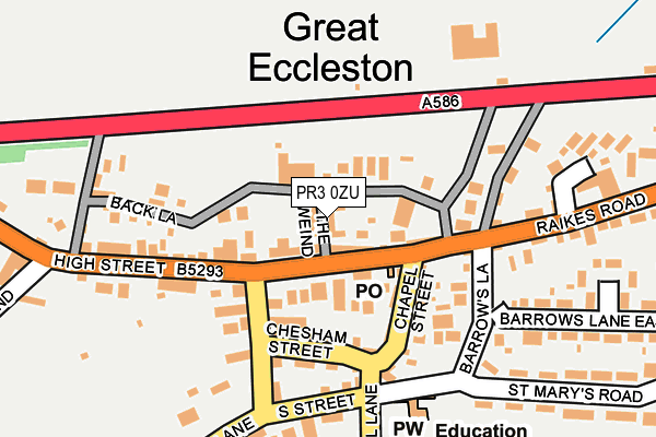
PR3 0ZU is located in the Great Eccleston electoral ward, within the local authority district of Wyre and the English Parliamentary constituency of Wyre and Preston North. The Sub Integrated Care Board (ICB) Location is NHS Lancashire and South Cumbria ICB - 02M and the police force is Lancashire. This postcode has been in use since June 1981.


GetTheData
Source: OS OpenMap – Local (Ordnance Survey)
Source: OS VectorMap District (Ordnance Survey)
Licence: Open Government Licence (requires attribution)
| Easting | 342743 |
| Northing | 440235 |
| Latitude | 53.855170 |
| Longitude | -2.871941 |
GetTheData
Source: Open Postcode Geo
Licence: Open Government Licence
| Country | England |
| Postcode District | PR3 |
➜ See where PR3 is on a map ➜ Where is Great Eccleston? | |
GetTheData
Source: Land Registry Price Paid Data
Licence: Open Government Licence
Elevation or altitude of PR3 0ZU as distance above sea level:
| Metres | Feet | |
|---|---|---|
| Elevation | 10m | 33ft |
Elevation is measured from the approximate centre of the postcode, to the nearest point on an OS contour line from OS Terrain 50, which has contour spacing of ten vertical metres.
➜ How high above sea level am I? Find the elevation of your current position using your device's GPS.
GetTheData
Source: Open Postcode Elevation
Licence: Open Government Licence
| Ward | Great Eccleston |
| Constituency | Wyre And Preston North |
GetTheData
Source: ONS Postcode Database
Licence: Open Government Licence
| White Bull (Back Lane) | Great Eccleston | 62m |
| Square (The Square) | Great Eccleston | 64m |
| Square (High Street) | Great Eccleston | 110m |
| St Marys Rcps (Hall Lane) | Great Eccleston | 182m |
| Chesham Lodge (Copp Lane) | Great Eccleston | 224m |
GetTheData
Source: NaPTAN
Licence: Open Government Licence
GetTheData
Source: ONS Postcode Database
Licence: Open Government Licence


➜ Get more ratings from the Food Standards Agency
GetTheData
Source: Food Standards Agency
Licence: FSA terms & conditions
| Last Collection | |||
|---|---|---|---|
| Location | Mon-Fri | Sat | Distance |
| Great Singleton | 17:30 | 12:00 | 5,097m |
GetTheData
Source: Dracos
Licence: Creative Commons Attribution-ShareAlike
The below table lists the International Territorial Level (ITL) codes (formerly Nomenclature of Territorial Units for Statistics (NUTS) codes) and Local Administrative Units (LAU) codes for PR3 0ZU:
| ITL 1 Code | Name |
|---|---|
| TLD | North West (England) |
| ITL 2 Code | Name |
| TLD4 | Lancashire |
| ITL 3 Code | Name |
| TLD44 | Lancaster and Wyre |
| LAU 1 Code | Name |
| E07000128 | Wyre |
GetTheData
Source: ONS Postcode Directory
Licence: Open Government Licence
The below table lists the Census Output Area (OA), Lower Layer Super Output Area (LSOA), and Middle Layer Super Output Area (MSOA) for PR3 0ZU:
| Code | Name | |
|---|---|---|
| OA | E00129711 | |
| LSOA | E01025562 | Wyre 009B |
| MSOA | E02005327 | Wyre 009 |
GetTheData
Source: ONS Postcode Directory
Licence: Open Government Licence
| PR3 0XJ | Back Lane | 51m |
| PR3 0YB | High Street | 72m |
| PR3 0ZB | The Square | 74m |
| PR3 0ZE | Chapel Street | 110m |
| PR3 0YD | Chesham Street | 113m |
| PR3 0YE | Halsall Square | 126m |
| PR3 0ZH | Barrows Lane | 142m |
| PR3 0ZD | Leckonby Street | 144m |
| PR3 0YH | South Street | 182m |
| PR3 0YL | West End | 211m |
GetTheData
Source: Open Postcode Geo; Land Registry Price Paid Data
Licence: Open Government Licence