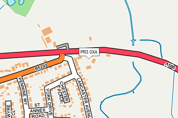
PR3 0XA is located in the Great Eccleston electoral ward, within the local authority district of Wyre and the English Parliamentary constituency of Wyre and Preston North. The Sub Integrated Care Board (ICB) Location is NHS Lancashire and South Cumbria ICB - 02M and the police force is Lancashire. This postcode has been in use since June 1981.


GetTheData
Source: OS OpenMap – Local (Ordnance Survey)
Source: OS VectorMap District (Ordnance Survey)
Licence: Open Government Licence (requires attribution)
| Easting | 343422 |
| Northing | 440347 |
| Latitude | 53.856265 |
| Longitude | -2.861636 |
GetTheData
Source: Open Postcode Geo
Licence: Open Government Licence
| Country | England |
| Postcode District | PR3 |
➜ See where PR3 is on a map ➜ Where is Great Eccleston? | |
GetTheData
Source: Land Registry Price Paid Data
Licence: Open Government Licence
Elevation or altitude of PR3 0XA as distance above sea level:
| Metres | Feet | |
|---|---|---|
| Elevation | 10m | 33ft |
Elevation is measured from the approximate centre of the postcode, to the nearest point on an OS contour line from OS Terrain 50, which has contour spacing of ten vertical metres.
➜ How high above sea level am I? Find the elevation of your current position using your device's GPS.
GetTheData
Source: Open Postcode Elevation
Licence: Open Government Licence
| Ward | Great Eccleston |
| Constituency | Wyre And Preston North |
GetTheData
Source: ONS Postcode Database
Licence: Open Government Licence
| Raikes Road | Great Eccleston | 140m |
| Raikes Road | Great Eccleston | 167m |
| Health Centre (Raikes Road) | Great Eccleston | 415m |
| Health Centre (Raikes Road) | Great Eccleston | 433m |
| White House Lane (Garstang Road) | Great Eccleston | 613m |
GetTheData
Source: NaPTAN
Licence: Open Government Licence
| Percentage of properties with Next Generation Access | 100.0% |
| Percentage of properties with Superfast Broadband | 66.7% |
| Percentage of properties with Ultrafast Broadband | 0.0% |
| Percentage of properties with Full Fibre Broadband | 0.0% |
Superfast Broadband is between 30Mbps and 300Mbps
Ultrafast Broadband is > 300Mbps
| Percentage of properties unable to receive 2Mbps | 0.0% |
| Percentage of properties unable to receive 5Mbps | 16.7% |
| Percentage of properties unable to receive 10Mbps | 16.7% |
| Percentage of properties unable to receive 30Mbps | 33.3% |
GetTheData
Source: Ofcom
Licence: Ofcom Terms of Use (requires attribution)
GetTheData
Source: ONS Postcode Database
Licence: Open Government Licence


➜ Get more ratings from the Food Standards Agency
GetTheData
Source: Food Standards Agency
Licence: FSA terms & conditions
| Risk of PR3 0XA flooding from rivers and sea | Low |
| ➜ PR3 0XA flood map | |
GetTheData
Source: Open Flood Risk by Postcode
Licence: Open Government Licence
The below table lists the International Territorial Level (ITL) codes (formerly Nomenclature of Territorial Units for Statistics (NUTS) codes) and Local Administrative Units (LAU) codes for PR3 0XA:
| ITL 1 Code | Name |
|---|---|
| TLD | North West (England) |
| ITL 2 Code | Name |
| TLD4 | Lancashire |
| ITL 3 Code | Name |
| TLD44 | Lancaster and Wyre |
| LAU 1 Code | Name |
| E07000128 | Wyre |
GetTheData
Source: ONS Postcode Directory
Licence: Open Government Licence
The below table lists the Census Output Area (OA), Lower Layer Super Output Area (LSOA), and Middle Layer Super Output Area (MSOA) for PR3 0XA:
| Code | Name | |
|---|---|---|
| OA | E00129709 | |
| LSOA | E01025562 | Wyre 009B |
| MSOA | E02005327 | Wyre 009 |
GetTheData
Source: ONS Postcode Directory
Licence: Open Government Licence
| PR3 0XX | Lancaster Avenue | 156m |
| PR3 0YA | Raikes Road | 159m |
| PR3 0XY | Chester Place | 168m |
| PR3 0XU | York Drive | 186m |
| PR3 0UY | Ripon Close | 237m |
| PR3 0UT | Lancaster Close | 268m |
| PR3 0YS | Pennine Way | 296m |
| PR3 0ZS | Raikes Road | 329m |
| PR3 0XT | Wyre Close | 335m |
| PR3 0YW | Orchard End | 361m |
GetTheData
Source: Open Postcode Geo; Land Registry Price Paid Data
Licence: Open Government Licence