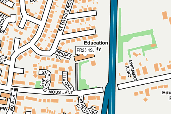
PR25 4SJ is located in the St Ambrose electoral ward, within the local authority district of South Ribble and the English Parliamentary constituency of South Ribble. The Sub Integrated Care Board (ICB) Location is NHS Lancashire and South Cumbria ICB - 00X and the police force is Lancashire. This postcode has been in use since June 2001.


GetTheData
Source: OS OpenMap – Local (Ordnance Survey)
Source: OS VectorMap District (Ordnance Survey)
Licence: Open Government Licence (requires attribution)
| Easting | 355273 |
| Northing | 422774 |
| Latitude | 53.699475 |
| Longitude | -2.678931 |
GetTheData
Source: Open Postcode Geo
Licence: Open Government Licence
| Country | England |
| Postcode District | PR25 |
➜ See where PR25 is on a map ➜ Where is Leyland? | |
GetTheData
Source: Land Registry Price Paid Data
Licence: Open Government Licence
Elevation or altitude of PR25 4SJ as distance above sea level:
| Metres | Feet | |
|---|---|---|
| Elevation | 50m | 164ft |
Elevation is measured from the approximate centre of the postcode, to the nearest point on an OS contour line from OS Terrain 50, which has contour spacing of ten vertical metres.
➜ How high above sea level am I? Find the elevation of your current position using your device's GPS.
GetTheData
Source: Open Postcode Elevation
Licence: Open Government Licence
| Ward | St Ambrose |
| Constituency | South Ribble |
GetTheData
Source: ONS Postcode Database
Licence: Open Government Licence
| St Catherines Rcps (Priory Close) | Turpin Green | 53m |
| Wychwood Grove (Wigan Road) | Clayton-le-woods | 399m |
| Melton Place (Bow Lane) | Turpin Green | 433m |
| Melton Place (Bow Lane) | Turpin Green | 439m |
| Wychwood Grove (Wigan Road) | Clayton-le-woods | 466m |
| Leyland Station | 0.5km |
| Lostock Hall Station | 2.8km |
| Buckshaw Parkway Station | 3.1km |
GetTheData
Source: NaPTAN
Licence: Open Government Licence
GetTheData
Source: ONS Postcode Database
Licence: Open Government Licence


➜ Get more ratings from the Food Standards Agency
GetTheData
Source: Food Standards Agency
Licence: FSA terms & conditions
| Last Collection | |||
|---|---|---|---|
| Location | Mon-Fri | Sat | Distance |
| 43 Stanfield Lane, Farington | 17:00 | 11:30 | 449m |
| 72 Turpin Green Lane | 17:30 | 12:30 | 750m |
| North Gate | 17:30 | 11:30 | 782m |
GetTheData
Source: Dracos
Licence: Creative Commons Attribution-ShareAlike
The below table lists the International Territorial Level (ITL) codes (formerly Nomenclature of Territorial Units for Statistics (NUTS) codes) and Local Administrative Units (LAU) codes for PR25 4SJ:
| ITL 1 Code | Name |
|---|---|
| TLD | North West (England) |
| ITL 2 Code | Name |
| TLD4 | Lancashire |
| ITL 3 Code | Name |
| TLD45 | Mid Lancashire |
| LAU 1 Code | Name |
| E07000126 | South Ribble |
GetTheData
Source: ONS Postcode Directory
Licence: Open Government Licence
The below table lists the Census Output Area (OA), Lower Layer Super Output Area (LSOA), and Middle Layer Super Output Area (MSOA) for PR25 4SJ:
| Code | Name | |
|---|---|---|
| OA | E00129067 | |
| LSOA | E01025433 | South Ribble 013D |
| MSOA | E02005299 | South Ribble 013 |
GetTheData
Source: ONS Postcode Directory
Licence: Open Government Licence
| PR25 4XZ | Priory Close | 98m |
| PR25 4SW | The Chase | 110m |
| PR25 4XX | St Davids Road | 110m |
| PR25 4SZ | The Cloisters | 157m |
| PR25 4XY | St Davids Road | 164m |
| PR25 5SL | Wilmar Road | 174m |
| PR25 4SH | Moss Lane | 184m |
| PR25 4XN | Lever House Lane | 207m |
| PR25 4ZY | St Catherines Close | 210m |
| PR25 4XL | Lever House Lane | 231m |
GetTheData
Source: Open Postcode Geo; Land Registry Price Paid Data
Licence: Open Government Licence