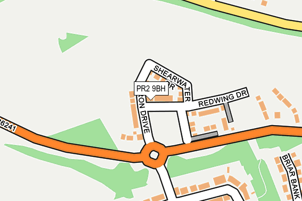
PR2 9BH is located in the Preston Rural East electoral ward, within the local authority district of Preston and the English Parliamentary constituency of Wyre and Preston North. The Sub Integrated Care Board (ICB) Location is NHS Lancashire and South Cumbria ICB - 01E and the police force is Lancashire. This postcode has been in use since March 2017.


GetTheData
Source: OS OpenMap – Local (Ordnance Survey)
Source: OS VectorMap District (Ordnance Survey)
Licence: Open Government Licence (requires attribution)
| Easting | 353692 |
| Northing | 433984 |
| Latitude | 53.800100 |
| Longitude | -2.704557 |
GetTheData
Source: Open Postcode Geo
Licence: Open Government Licence
| Country | England |
| Postcode District | PR2 |
➜ See where PR2 is on a map ➜ Where is Broughton? | |
GetTheData
Source: Land Registry Price Paid Data
Licence: Open Government Licence
| Ward | Preston Rural East |
| Constituency | Wyre And Preston North |
GetTheData
Source: ONS Postcode Database
Licence: Open Government Licence
2023 4 AUG £457,000 |
17, HERON DRIVE, FULWOOD, PRESTON, PR2 9BH 2022 1 APR £469,995 |
19, HERON DRIVE, FULWOOD, PRESTON, PR2 9BH 2022 1 APR £352,995 |
15, HERON DRIVE, FULWOOD, PRESTON, PR2 9BH 2022 18 MAR £389,995 |
13, HERON DRIVE, FULWOOD, PRESTON, PR2 9BH 2022 4 MAR £341,995 |
9, HERON DRIVE, FULWOOD, PRESTON, PR2 9BH 2017 31 MAR £316,995 |
11, HERON DRIVE, FULWOOD, PRESTON, PR2 9BH 2017 31 MAR £414,995 |
14, HERON DRIVE, FULWOOD, PRESTON, PR2 9BH 2017 31 MAR £392,995 |
7, HERON DRIVE, FULWOOD, PRESTON, PR2 9BH 2017 31 MAR £299,995 |
3, HERON DRIVE, FULWOOD, PRESTON, PR2 9BH 2017 30 MAR £426,995 |
GetTheData
Source: HM Land Registry Price Paid Data
Licence: Contains HM Land Registry data © Crown copyright and database right 2025. This data is licensed under the Open Government Licence v3.0.
| Ashness Close (Levensgarth Avenue) | Sherwood | 387m |
| Ashness Close (Levensgarth Avenue) | Sherwood | 403m |
| Moorfield Avenue (Broadwood Drive) | Sharoe Green | 553m |
| Broadwood Drive | Sharoe Green | 567m |
| Hellifield (Broadwood Drive) | Sharoe Green | 598m |
| Preston Station | 4.8km |
GetTheData
Source: NaPTAN
Licence: Open Government Licence
| Percentage of properties with Next Generation Access | 100.0% |
| Percentage of properties with Superfast Broadband | 100.0% |
| Percentage of properties with Ultrafast Broadband | 100.0% |
| Percentage of properties with Full Fibre Broadband | 100.0% |
Superfast Broadband is between 30Mbps and 300Mbps
Ultrafast Broadband is > 300Mbps
| Median download speed | 100.0Mbps |
| Average download speed | 125.0Mbps |
| Maximum download speed | 200.00Mbps |
Ofcom does not currently provide upload speed data for PR2 9BH. This is because there are less than four broadband connections in this postcode.
| Percentage of properties unable to receive 2Mbps | 0.0% |
| Percentage of properties unable to receive 5Mbps | 0.0% |
| Percentage of properties unable to receive 10Mbps | 0.0% |
| Percentage of properties unable to receive 30Mbps | 0.0% |
GetTheData
Source: Ofcom
Licence: Ofcom Terms of Use (requires attribution)
GetTheData
Source: ONS Postcode Database
Licence: Open Government Licence


➜ Get more ratings from the Food Standards Agency
GetTheData
Source: Food Standards Agency
Licence: FSA terms & conditions
| Last Collection | |||
|---|---|---|---|
| Location | Mon-Fri | Sat | Distance |
| Levensgarth Avenue | 17:30 | 11:30 | 215m |
| Durton Lane, Warwick House | 17:00 | 10:00 | 245m |
| 8 South Drive, Fulwood | 17:45 | 11:30 | 731m |
GetTheData
Source: Dracos
Licence: Creative Commons Attribution-ShareAlike
The below table lists the International Territorial Level (ITL) codes (formerly Nomenclature of Territorial Units for Statistics (NUTS) codes) and Local Administrative Units (LAU) codes for PR2 9BH:
| ITL 1 Code | Name |
|---|---|
| TLD | North West (England) |
| ITL 2 Code | Name |
| TLD4 | Lancashire |
| ITL 3 Code | Name |
| TLD45 | Mid Lancashire |
| LAU 1 Code | Name |
| E07000123 | Preston |
GetTheData
Source: ONS Postcode Directory
Licence: Open Government Licence
The below table lists the Census Output Area (OA), Lower Layer Super Output Area (LSOA), and Middle Layer Super Output Area (MSOA) for PR2 9BH:
| Code | Name | |
|---|---|---|
| OA | E00128290 | |
| LSOA | E01025277 | Preston 002B |
| MSOA | E02005254 | Preston 002 |
GetTheData
Source: ONS Postcode Directory
Licence: Open Government Licence
| PR2 9FU | Longfield | 254m |
| PR2 9FP | Levensgarth Avenue | 269m |
| PR2 9FE | Langport Close | 287m |
| PR3 5LE | Durton Lane | 289m |
| PR2 9FN | Langfield Close | 290m |
| PR3 5LG | St Johns Court | 313m |
| PR2 9FL | Longley Close | 317m |
| PR3 5LJ | Highrigg Drive | 336m |
| PR2 9TB | Longley Close | 346m |
| PR2 9RN | Longfield | 357m |
GetTheData
Source: Open Postcode Geo; Land Registry Price Paid Data
Licence: Open Government Licence