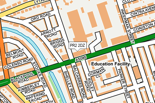
PR2 2DZ is located in the Cadley electoral ward, within the local authority district of Preston and the English Parliamentary constituency of Preston. The Sub Integrated Care Board (ICB) Location is NHS Lancashire and South Cumbria ICB - 01E and the police force is Lancashire. This postcode has been in use since May 2011.


GetTheData
Source: OS OpenMap – Local (Ordnance Survey)
Source: OS VectorMap District (Ordnance Survey)
Licence: Open Government Licence (requires attribution)
| Easting | 352373 |
| Northing | 430864 |
| Latitude | 53.771941 |
| Longitude | -2.724097 |
GetTheData
Source: Open Postcode Geo
Licence: Open Government Licence
| Country | England |
| Postcode District | PR2 |
➜ See where PR2 is on a map ➜ Where is Preston? | |
GetTheData
Source: Land Registry Price Paid Data
Licence: Open Government Licence
Elevation or altitude of PR2 2DZ as distance above sea level:
| Metres | Feet | |
|---|---|---|
| Elevation | 20m | 66ft |
Elevation is measured from the approximate centre of the postcode, to the nearest point on an OS contour line from OS Terrain 50, which has contour spacing of ten vertical metres.
➜ How high above sea level am I? Find the elevation of your current position using your device's GPS.
GetTheData
Source: Open Postcode Elevation
Licence: Open Government Licence
| Ward | Cadley |
| Constituency | Preston |
GetTheData
Source: ONS Postcode Database
Licence: Open Government Licence
| Balcarres Road (Blackpool Road) | Ashton-on-ribble | 40m |
| Balcarres Road (Blackpool Road) | Ashton-on-ribble | 51m |
| Parker Street (Blackpool Road) | Ashton-on-ribble | 96m |
| Inkerman Street (Blackpool Road) | Ashton-on-ribble | 144m |
| Stock Rd (Blackpool Road) | Ashton-on-ribble | 214m |
| Preston Station | 2km |
GetTheData
Source: NaPTAN
Licence: Open Government Licence
GetTheData
Source: ONS Postcode Database
Licence: Open Government Licence


➜ Get more ratings from the Food Standards Agency
GetTheData
Source: Food Standards Agency
Licence: FSA terms & conditions
| Last Collection | |||
|---|---|---|---|
| Location | Mon-Fri | Sat | Distance |
| 124 Lytham Road, Fulwood | 17:00 | 11:30 | 441m |
| Cattle Market Post Office | 17:30 | 11:15 | 602m |
| Cadley Bank | 17:00 | 11:30 | 723m |
GetTheData
Source: Dracos
Licence: Creative Commons Attribution-ShareAlike
The below table lists the International Territorial Level (ITL) codes (formerly Nomenclature of Territorial Units for Statistics (NUTS) codes) and Local Administrative Units (LAU) codes for PR2 2DZ:
| ITL 1 Code | Name |
|---|---|
| TLD | North West (England) |
| ITL 2 Code | Name |
| TLD4 | Lancashire |
| ITL 3 Code | Name |
| TLD45 | Mid Lancashire |
| LAU 1 Code | Name |
| E07000123 | Preston |
GetTheData
Source: ONS Postcode Directory
Licence: Open Government Licence
The below table lists the Census Output Area (OA), Lower Layer Super Output Area (LSOA), and Middle Layer Super Output Area (MSOA) for PR2 2DZ:
| Code | Name | |
|---|---|---|
| OA | E00128462 | |
| LSOA | E01025311 | Preston 012D |
| MSOA | E02005264 | Preston 012 |
GetTheData
Source: ONS Postcode Directory
Licence: Open Government Licence
| PR2 2BG | Brook Court | 59m |
| PR2 2DT | Blackpool Road | 86m |
| PR2 2BF | Dorman Close | 100m |
| PR2 2EA | Briggs Road | 107m |
| PR2 2DY | Balcarres Road | 111m |
| PR2 2BT | Balcarres Road | 120m |
| PR2 2BS | Ridley Road | 127m |
| PR2 2EH | Shelley Road | 134m |
| PR2 2EB | Arnott Road | 139m |
| PR2 2AW | Mill Court | 141m |
GetTheData
Source: Open Postcode Geo; Land Registry Price Paid Data
Licence: Open Government Licence