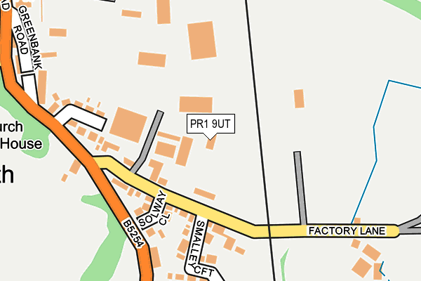
PR1 9UT is located in the Middleforth electoral ward, within the local authority district of South Ribble and the English Parliamentary constituency of South Ribble. The Sub Integrated Care Board (ICB) Location is NHS Lancashire and South Cumbria ICB - 01E and the police force is Lancashire. This postcode has been in use since January 1980.


GetTheData
Source: OS OpenMap – Local (Ordnance Survey)
Source: OS VectorMap District (Ordnance Survey)
Licence: Open Government Licence (requires attribution)
| Easting | 353549 |
| Northing | 427528 |
| Latitude | 53.742050 |
| Longitude | -2.705756 |
GetTheData
Source: Open Postcode Geo
Licence: Open Government Licence
| Country | England |
| Postcode District | PR1 |
➜ See where PR1 is on a map ➜ Where is Penwortham? | |
GetTheData
Source: Land Registry Price Paid Data
Licence: Open Government Licence
Elevation or altitude of PR1 9UT as distance above sea level:
| Metres | Feet | |
|---|---|---|
| Elevation | 10m | 33ft |
Elevation is measured from the approximate centre of the postcode, to the nearest point on an OS contour line from OS Terrain 50, which has contour spacing of ten vertical metres.
➜ How high above sea level am I? Find the elevation of your current position using your device's GPS.
GetTheData
Source: Open Postcode Elevation
Licence: Open Government Licence
| Ward | Middleforth |
| Constituency | South Ribble |
GetTheData
Source: ONS Postcode Database
Licence: Open Government Licence
| Factory Lane (Leyland Road) | Middleforth Green | 177m |
| Factory Lane (Leyland Road) | Middleforth Green | 202m |
| Middleforth Garage (Greenbank Road) | Middleforth Green | 344m |
| New Lane School Stop (New Lane) | Penwortham Lane | 362m |
| Marshalls Brow | Middleforth Green | 363m |
| Preston Station | 1.7km |
| Lostock Hall Station | 2.3km |
| Bamber Bridge Station | 3.4km |
GetTheData
Source: NaPTAN
Licence: Open Government Licence
GetTheData
Source: ONS Postcode Database
Licence: Open Government Licence


➜ Get more ratings from the Food Standards Agency
GetTheData
Source: Food Standards Agency
Licence: FSA terms & conditions
| Last Collection | |||
|---|---|---|---|
| Location | Mon-Fri | Sat | Distance |
| Studholme Crescent | 17:30 | 11:30 | 443m |
| The Cawsey | 16:45 | 11:30 | 1,077m |
| Pedders Lane | 17:00 | 11:30 | 1,417m |
GetTheData
Source: Dracos
Licence: Creative Commons Attribution-ShareAlike
| Risk of PR1 9UT flooding from rivers and sea | Low |
| ➜ PR1 9UT flood map | |
GetTheData
Source: Open Flood Risk by Postcode
Licence: Open Government Licence
The below table lists the International Territorial Level (ITL) codes (formerly Nomenclature of Territorial Units for Statistics (NUTS) codes) and Local Administrative Units (LAU) codes for PR1 9UT:
| ITL 1 Code | Name |
|---|---|
| TLD | North West (England) |
| ITL 2 Code | Name |
| TLD4 | Lancashire |
| ITL 3 Code | Name |
| TLD45 | Mid Lancashire |
| LAU 1 Code | Name |
| E07000126 | South Ribble |
GetTheData
Source: ONS Postcode Directory
Licence: Open Government Licence
The below table lists the Census Output Area (OA), Lower Layer Super Output Area (LSOA), and Middle Layer Super Output Area (MSOA) for PR1 9UT:
| Code | Name | |
|---|---|---|
| OA | E00129157 | |
| LSOA | E01025450 | South Ribble 005D |
| MSOA | E02005291 | South Ribble 005 |
GetTheData
Source: ONS Postcode Directory
Licence: Open Government Licence
| PR1 9TD | Factory Lane | 95m |
| PR1 9RT | Solway Close | 155m |
| PR1 9TB | Middleforth Green | 198m |
| PR1 9TZ | Smalley Croft | 202m |
| PR1 9TE | Factory Lane | 254m |
| PR1 9QN | Greenbank Road | 259m |
| PR1 9QB | Leyland Road | 308m |
| PR1 9TH | Pembury Avenue | 308m |
| PR1 9QA | Leyland Road | 309m |
| PR1 9JL | Hall Road | 315m |
GetTheData
Source: Open Postcode Geo; Land Registry Price Paid Data
Licence: Open Government Licence