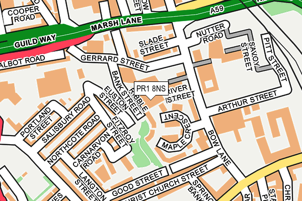
PR1 8NS is located in the City Centre electoral ward, within the local authority district of Preston and the English Parliamentary constituency of Preston. The Sub Integrated Care Board (ICB) Location is NHS Lancashire and South Cumbria ICB - 01E and the police force is Lancashire. This postcode has been in use since April 1985.


GetTheData
Source: OS OpenMap – Local (Ordnance Survey)
Source: OS VectorMap District (Ordnance Survey)
Licence: Open Government Licence (requires attribution)
| Easting | 353090 |
| Northing | 429304 |
| Latitude | 53.757970 |
| Longitude | -2.712985 |
GetTheData
Source: Open Postcode Geo
Licence: Open Government Licence
| Country | England |
| Postcode District | PR1 |
➜ See where PR1 is on a map ➜ Where is Preston? | |
GetTheData
Source: Land Registry Price Paid Data
Licence: Open Government Licence
Elevation or altitude of PR1 8NS as distance above sea level:
| Metres | Feet | |
|---|---|---|
| Elevation | 10m | 33ft |
Elevation is measured from the approximate centre of the postcode, to the nearest point on an OS contour line from OS Terrain 50, which has contour spacing of ten vertical metres.
➜ How high above sea level am I? Find the elevation of your current position using your device's GPS.
GetTheData
Source: Open Postcode Elevation
Licence: Open Government Licence
| Ward | City Centre |
| Constituency | Preston |
GetTheData
Source: ONS Postcode Database
Licence: Open Government Licence
| Bow Lane | Preston City Centre | 117m |
| Slade Street (Bow Lane) | Preston City Centre | 124m |
| Christ Church Street (Bow Lane) | Preston City Centre | 171m |
| Christ Church St (Bow Lane) | Preston City Centre | 222m |
| Northcote Road (Hartington Road) | Broadgate | 241m |
| Preston Station | 0.3km |
| Lostock Hall Station | 4.1km |
| Bamber Bridge Station | 4.9km |
GetTheData
Source: NaPTAN
Licence: Open Government Licence
GetTheData
Source: ONS Postcode Database
Licence: Open Government Licence


➜ Get more ratings from the Food Standards Agency
GetTheData
Source: Food Standards Agency
Licence: FSA terms & conditions
| Last Collection | |||
|---|---|---|---|
| Location | Mon-Fri | Sat | Distance |
| Bow Lane | 141m | ||
| Bow Lane | 18:30 | 11:30 | 142m |
| Marsh Lane | 18:30 | 11:30 | 318m |
GetTheData
Source: Dracos
Licence: Creative Commons Attribution-ShareAlike
The below table lists the International Territorial Level (ITL) codes (formerly Nomenclature of Territorial Units for Statistics (NUTS) codes) and Local Administrative Units (LAU) codes for PR1 8NS:
| ITL 1 Code | Name |
|---|---|
| TLD | North West (England) |
| ITL 2 Code | Name |
| TLD4 | Lancashire |
| ITL 3 Code | Name |
| TLD45 | Mid Lancashire |
| LAU 1 Code | Name |
| E07000123 | Preston |
GetTheData
Source: ONS Postcode Directory
Licence: Open Government Licence
The below table lists the Census Output Area (OA), Lower Layer Super Output Area (LSOA), and Middle Layer Super Output Area (MSOA) for PR1 8NS:
| Code | Name | |
|---|---|---|
| OA | E00128356 | |
| LSOA | E01025289 | Preston 017A |
| MSOA | E02005269 | Preston 017 |
GetTheData
Source: ONS Postcode Directory
Licence: Open Government Licence
| PR1 8AH | Ribble Bank Street | 31m |
| PR1 8ND | Bow Lane | 75m |
| PR1 8NR | Maple Crescent | 79m |
| PR1 8PD | Fitzroy Street | 86m |
| PR1 8PB | Euston Street | 90m |
| PR1 8NE | Slade Street | 116m |
| PR1 8NP | Kingswood Street | 123m |
| PR1 8PX | Burleigh Road | 124m |
| PR1 8PW | Fitzroy Street | 134m |
| PR1 8NL | Marsh Lane | 142m |
GetTheData
Source: Open Postcode Geo; Land Registry Price Paid Data
Licence: Open Government Licence