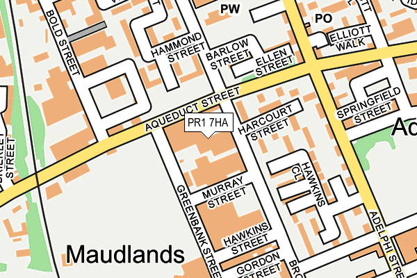
PR1 7HA is located in the Plungington electoral ward, within the local authority district of Preston and the English Parliamentary constituency of Preston. The Sub Integrated Care Board (ICB) Location is NHS Lancashire and South Cumbria ICB - 01E and the police force is Lancashire. This postcode has been in use since May 1994.


GetTheData
Source: OS OpenMap – Local (Ordnance Survey)
Source: OS VectorMap District (Ordnance Survey)
Licence: Open Government Licence (requires attribution)
| Easting | 353137 |
| Northing | 430351 |
| Latitude | 53.767384 |
| Longitude | -2.712432 |
GetTheData
Source: Open Postcode Geo
Licence: Open Government Licence
| Country | England |
| Postcode District | PR1 |
➜ See where PR1 is on a map ➜ Where is Preston? | |
GetTheData
Source: Land Registry Price Paid Data
Licence: Open Government Licence
Elevation or altitude of PR1 7HA as distance above sea level:
| Metres | Feet | |
|---|---|---|
| Elevation | 30m | 98ft |
Elevation is measured from the approximate centre of the postcode, to the nearest point on an OS contour line from OS Terrain 50, which has contour spacing of ten vertical metres.
➜ How high above sea level am I? Find the elevation of your current position using your device's GPS.
GetTheData
Source: Open Postcode Elevation
Licence: Open Government Licence
| Ward | Plungington |
| Constituency | Preston |
GetTheData
Source: ONS Postcode Database
Licence: Open Government Licence
| Harcourt Street (Brook Street) | Plungington | 53m |
| Barlow Street (Brook Street) | Plungington | 95m |
| Barlow Street (Brook Street) | Plungington | 107m |
| Aqueduct Street (Plungington Road) | Plungington | 183m |
| Aqueduct Street (Plungington Road) | Plungington | 185m |
| Preston Station | 1.2km |
| Lostock Hall Station | 5.1km |
| Bamber Bridge Station | 5.7km |
GetTheData
Source: NaPTAN
Licence: Open Government Licence
GetTheData
Source: ONS Postcode Database
Licence: Open Government Licence


➜ Get more ratings from the Food Standards Agency
GetTheData
Source: Food Standards Agency
Licence: FSA terms & conditions
| Last Collection | |||
|---|---|---|---|
| Location | Mon-Fri | Sat | Distance |
| Navigation Way, Ashton | 187m | ||
| 131 Waterloo Road, Ashton | 17:00 | 11:30 | 312m |
| Tulketh Road | 17:00 | 11:30 | 445m |
GetTheData
Source: Dracos
Licence: Creative Commons Attribution-ShareAlike
The below table lists the International Territorial Level (ITL) codes (formerly Nomenclature of Territorial Units for Statistics (NUTS) codes) and Local Administrative Units (LAU) codes for PR1 7HA:
| ITL 1 Code | Name |
|---|---|
| TLD | North West (England) |
| ITL 2 Code | Name |
| TLD4 | Lancashire |
| ITL 3 Code | Name |
| TLD45 | Mid Lancashire |
| LAU 1 Code | Name |
| E07000123 | Preston |
GetTheData
Source: ONS Postcode Directory
Licence: Open Government Licence
The below table lists the Census Output Area (OA), Lower Layer Super Output Area (LSOA), and Middle Layer Super Output Area (MSOA) for PR1 7HA:
| Code | Name | |
|---|---|---|
| OA | E00128483 | |
| LSOA | E01025313 | Preston 012F |
| MSOA | E02005264 | Preston 012 |
GetTheData
Source: ONS Postcode Directory
Licence: Open Government Licence
| PR1 7JH | Aqueduct Street | 46m |
| PR1 7EQ | Harcourt Street | 95m |
| PR1 7ER | Harcourt Street | 107m |
| PR1 7LL | Hammond Court | 113m |
| PR1 7HY | Murray Street | 120m |
| PR1 7ST | Barlow Street | 122m |
| PR1 7HQ | Eversleigh Street | 130m |
| PR1 7NU | Hammond Street | 153m |
| PR1 7TB | Ellen Street | 157m |
| PR1 7EP | Plungington Road | 176m |
GetTheData
Source: Open Postcode Geo; Land Registry Price Paid Data
Licence: Open Government Licence