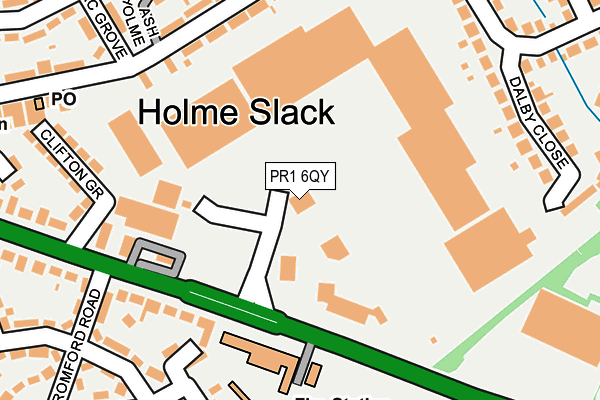
PR1 6QY lies on Deepdale Park in Preston. PR1 6QY is located in the Deepdale electoral ward, within the local authority district of Preston and the English Parliamentary constituency of Preston. The Sub Integrated Care Board (ICB) Location is NHS Lancashire and South Cumbria ICB - 01E and the police force is Lancashire. This postcode has been in use since July 1990.


GetTheData
Source: OS OpenMap – Local (Ordnance Survey)
Source: OS VectorMap District (Ordnance Survey)
Licence: Open Government Licence (requires attribution)
| Easting | 355387 |
| Northing | 431000 |
| Latitude | 53.773415 |
| Longitude | -2.678394 |
GetTheData
Source: Open Postcode Geo
Licence: Open Government Licence
| Street | Deepdale Park |
| Town/City | Preston |
| Country | England |
| Postcode District | PR1 |
➜ See where PR1 is on a map ➜ Where is Preston? | |
GetTheData
Source: Land Registry Price Paid Data
Licence: Open Government Licence
Elevation or altitude of PR1 6QY as distance above sea level:
| Metres | Feet | |
|---|---|---|
| Elevation | 50m | 164ft |
Elevation is measured from the approximate centre of the postcode, to the nearest point on an OS contour line from OS Terrain 50, which has contour spacing of ten vertical metres.
➜ How high above sea level am I? Find the elevation of your current position using your device's GPS.
GetTheData
Source: Open Postcode Elevation
Licence: Open Government Licence
| Ward | Deepdale |
| Constituency | Preston |
GetTheData
Source: ONS Postcode Database
Licence: Open Government Licence
UNIT FC2C, DEEPDALE PARK, PRESTON, PR1 6QY 2002 16 AUG £500,000 |
GetTheData
Source: HM Land Registry Price Paid Data
Licence: Contains HM Land Registry data © Crown copyright and database right 2025. This data is licensed under the Open Government Licence v3.0.
| Retail Park (Deepdale Retail Park) | Holme Slack | 76m |
| Daisy Lane (Holme Slack Lane) | Holme Slack | 218m |
| Daisy Lane (Holme Slack Lane) | Holme Slack | 241m |
| Post Office (Holme Slack Lane) | Holme Slack | 245m |
| Romford Road (Blackpool Road) | Holme Slack | 262m |
| Preston Station | 2.7km |
GetTheData
Source: NaPTAN
Licence: Open Government Licence
| Median download speed | 21.6Mbps |
| Average download speed | 33.5Mbps |
| Maximum download speed | 80.00Mbps |
| Median upload speed | 1.2Mbps |
| Average upload speed | 6.4Mbps |
| Maximum upload speed | 20.00Mbps |
GetTheData
Source: Ofcom
Licence: Ofcom Terms of Use (requires attribution)
GetTheData
Source: ONS Postcode Database
Licence: Open Government Licence


➜ Get more ratings from the Food Standards Agency
GetTheData
Source: Food Standards Agency
Licence: FSA terms & conditions
| Last Collection | |||
|---|---|---|---|
| Location | Mon-Fri | Sat | Distance |
| 49 Newton Road, Ashton | 17:00 | 11:30 | 354m |
| Cemetery Post Office | 17:30 | 11:15 | 639m |
| New Hall Lane Post Office | 17:30 | 11:30 | 1,125m |
GetTheData
Source: Dracos
Licence: Creative Commons Attribution-ShareAlike
The below table lists the International Territorial Level (ITL) codes (formerly Nomenclature of Territorial Units for Statistics (NUTS) codes) and Local Administrative Units (LAU) codes for PR1 6QY:
| ITL 1 Code | Name |
|---|---|
| TLD | North West (England) |
| ITL 2 Code | Name |
| TLD4 | Lancashire |
| ITL 3 Code | Name |
| TLD45 | Mid Lancashire |
| LAU 1 Code | Name |
| E07000123 | Preston |
GetTheData
Source: ONS Postcode Directory
Licence: Open Government Licence
The below table lists the Census Output Area (OA), Lower Layer Super Output Area (LSOA), and Middle Layer Super Output Area (MSOA) for PR1 6QY:
| Code | Name | |
|---|---|---|
| OA | E00128134 | |
| LSOA | E01025245 | Preston 007E |
| MSOA | E02005259 | Preston 007 |
GetTheData
Source: ONS Postcode Directory
Licence: Open Government Licence
| PR1 6XA | Blackpool Road | 173m |
| PR1 6HA | Holme Slack Lane | 201m |
| PR1 6YL | Clifton Crescent | 216m |
| PR1 6XQ | Romford Road | 242m |
| PR1 6YJ | Clifton Grove | 250m |
| PR1 6EU | Dalby Close | 269m |
| PR1 6HR | Lilac Grove | 271m |
| PR1 6UY | Blackpool Road | 278m |
| PR1 6XB | Blackpool Road | 287m |
| PR1 6HE | Daisy Lane | 291m |
GetTheData
Source: Open Postcode Geo; Land Registry Price Paid Data
Licence: Open Government Licence