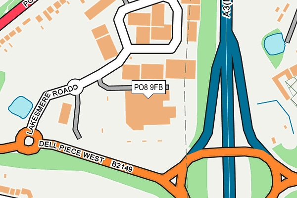
PO8 9FB is located in the Horndean Kings & Blendworth electoral ward, within the local authority district of East Hampshire and the English Parliamentary constituency of Meon Valley. The Sub Integrated Care Board (ICB) Location is NHS Hampshire and Isle of Wight ICB - D9Y0V and the police force is Hampshire. This postcode has been in use since January 1995.


GetTheData
Source: OS OpenMap – Local (Ordnance Survey)
Source: OS VectorMap District (Ordnance Survey)
Licence: Open Government Licence (requires attribution)
| Easting | 470307 |
| Northing | 112577 |
| Latitude | 50.908382 |
| Longitude | -1.001383 |
GetTheData
Source: Open Postcode Geo
Licence: Open Government Licence
| Country | England |
| Postcode District | PO8 |
➜ See where PO8 is on a map ➜ Where is Horndean? | |
GetTheData
Source: Land Registry Price Paid Data
Licence: Open Government Licence
Elevation or altitude of PO8 9FB as distance above sea level:
| Metres | Feet | |
|---|---|---|
| Elevation | 70m | 230ft |
Elevation is measured from the approximate centre of the postcode, to the nearest point on an OS contour line from OS Terrain 50, which has contour spacing of ten vertical metres.
➜ How high above sea level am I? Find the elevation of your current position using your device's GPS.
GetTheData
Source: Open Postcode Elevation
Licence: Open Government Licence
| Ward | Horndean Kings & Blendworth |
| Constituency | Meon Valley |
GetTheData
Source: ONS Postcode Database
Licence: Open Government Licence
| Merchistoun Hall (Portsmouth Road) | Horndean | 309m |
| Merchistoun Hall (Portsmouth Road) | Horndean | 313m |
| Catherington Lane (Portsmouth Road) | Horndean | 387m |
| Briars Close (Hazleton Way) | Horndean | 399m |
| Napier Road (Portsmouth Road) | Horndean | 405m |
| Rowlands Castle Station | 3.6km |
GetTheData
Source: NaPTAN
Licence: Open Government Licence
GetTheData
Source: ONS Postcode Database
Licence: Open Government Licence

➜ Get more ratings from the Food Standards Agency
GetTheData
Source: Food Standards Agency
Licence: FSA terms & conditions
| Last Collection | |||
|---|---|---|---|
| Location | Mon-Fri | Sat | Distance |
| Safeways Stores | 18:30 | 11:50 | 71m |
| Horndean Hill | 16:15 | 11:45 | 312m |
| Whitehaven | 16:30 | 11:45 | 505m |
GetTheData
Source: Dracos
Licence: Creative Commons Attribution-ShareAlike
The below table lists the International Territorial Level (ITL) codes (formerly Nomenclature of Territorial Units for Statistics (NUTS) codes) and Local Administrative Units (LAU) codes for PO8 9FB:
| ITL 1 Code | Name |
|---|---|
| TLJ | South East (England) |
| ITL 2 Code | Name |
| TLJ3 | Hampshire and Isle of Wight |
| ITL 3 Code | Name |
| TLJ36 | Central Hampshire |
| LAU 1 Code | Name |
| E07000085 | East Hampshire |
GetTheData
Source: ONS Postcode Directory
Licence: Open Government Licence
The below table lists the Census Output Area (OA), Lower Layer Super Output Area (LSOA), and Middle Layer Super Output Area (MSOA) for PO8 9FB:
| Code | Name | |
|---|---|---|
| OA | E00114937 | |
| LSOA | E01022610 | East Hampshire 016A |
| MSOA | E02006829 | East Hampshire 016 |
GetTheData
Source: ONS Postcode Directory
Licence: Open Government Licence
| PO8 9JU | Hazleton Interchange | 158m |
| PO8 9LL | Orchard Close | 271m |
| PO8 9LH | Portsmouth Road | 275m |
| PO8 9HD | Whitebeam Close | 282m |
| PO8 9EY | Hill View | 293m |
| PO8 9LN | Portsmouth Road | 321m |
| PO8 9DY | Linden Way | 333m |
| PO8 9EZ | Cedar Crescent | 382m |
| PO8 9JW | Rookes Close | 385m |
| PO8 0UW | Catkin Grove | 386m |
GetTheData
Source: Open Postcode Geo; Land Registry Price Paid Data
Licence: Open Government Licence