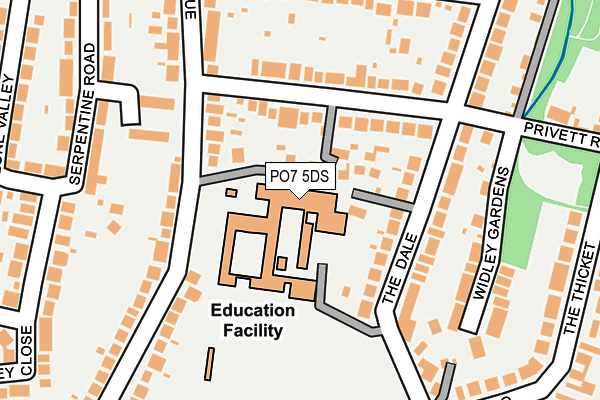
PO7 5DS is located in the Purbrook electoral ward, within the local authority district of Havant and the English Parliamentary constituency of Havant. The Sub Integrated Care Board (ICB) Location is NHS Hampshire and Isle of Wight ICB - D9Y0V and the police force is Hampshire. This postcode has been in use since January 1980.


GetTheData
Source: OS OpenMap – Local (Ordnance Survey)
Source: OS VectorMap District (Ordnance Survey)
Licence: Open Government Licence (requires attribution)
| Easting | 467649 |
| Northing | 107195 |
| Latitude | 50.860317 |
| Longitude | -1.040193 |
GetTheData
Source: Open Postcode Geo
Licence: Open Government Licence
| Country | England |
| Postcode District | PO7 |
➜ See where PO7 is on a map ➜ Where is Purbrook? | |
GetTheData
Source: Land Registry Price Paid Data
Licence: Open Government Licence
Elevation or altitude of PO7 5DS as distance above sea level:
| Metres | Feet | |
|---|---|---|
| Elevation | 50m | 164ft |
Elevation is measured from the approximate centre of the postcode, to the nearest point on an OS contour line from OS Terrain 50, which has contour spacing of ten vertical metres.
➜ How high above sea level am I? Find the elevation of your current position using your device's GPS.
GetTheData
Source: Open Postcode Elevation
Licence: Open Government Licence
| Ward | Purbrook |
| Constituency | Havant |
GetTheData
Source: ONS Postcode Database
Licence: Open Government Licence
| Purbrook Park School (Park Avenue) | Widley | 107m |
| Purbrook Park School (Park Avenue) | Widley | 122m |
| Privett Road (Park Avenue) | Widley | 198m |
| Frances Way (Park Avenue) | Purbrook | 267m |
| Parker Gardens (Park Avenue) | Widley | 383m |
| Cosham Station | 2.8km |
| Bedhampton Station | 3.2km |
| Hilsea Station | 3.8km |
GetTheData
Source: NaPTAN
Licence: Open Government Licence
GetTheData
Source: ONS Postcode Database
Licence: Open Government Licence


➜ Get more ratings from the Food Standards Agency
GetTheData
Source: Food Standards Agency
Licence: FSA terms & conditions
| Last Collection | |||
|---|---|---|---|
| Location | Mon-Fri | Sat | Distance |
| Privett Road | 17:00 | 12:25 | 165m |
| Park Avenue | 17:00 | 12:30 | 268m |
| Lone Valley | 17:00 | 12:20 | 300m |
GetTheData
Source: Dracos
Licence: Creative Commons Attribution-ShareAlike
The below table lists the International Territorial Level (ITL) codes (formerly Nomenclature of Territorial Units for Statistics (NUTS) codes) and Local Administrative Units (LAU) codes for PO7 5DS:
| ITL 1 Code | Name |
|---|---|
| TLJ | South East (England) |
| ITL 2 Code | Name |
| TLJ3 | Hampshire and Isle of Wight |
| ITL 3 Code | Name |
| TLJ35 | South Hampshire |
| LAU 1 Code | Name |
| E07000090 | Havant |
GetTheData
Source: ONS Postcode Directory
Licence: Open Government Licence
The below table lists the Census Output Area (OA), Lower Layer Super Output Area (LSOA), and Middle Layer Super Output Area (MSOA) for PO7 5DS:
| Code | Name | |
|---|---|---|
| OA | E00116627 | |
| LSOA | E01022951 | Havant 011E |
| MSOA | E02004772 | Havant 011 |
GetTheData
Source: ONS Postcode Directory
Licence: Open Government Licence
| PO7 5HJ | Privett Road | 87m |
| PO7 5JH | The Dale | 96m |
| PO7 5JB | The Dale | 139m |
| PO7 5DP | Park Avenue | 159m |
| PO7 5EH | Gitsham Gardens | 166m |
| PO7 5RB | Widley Gardens | 181m |
| PO7 5DR | Park Avenue | 187m |
| PO7 5EA | Lone Valley | 190m |
| PO7 5JD | The Dale | 205m |
| PO7 5HF | Park Avenue | 227m |
GetTheData
Source: Open Postcode Geo; Land Registry Price Paid Data
Licence: Open Government Licence