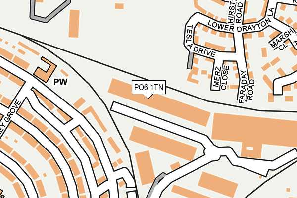
PO6 1TN is located in the Drayton and Farlington electoral ward, within the unitary authority of Portsmouth and the English Parliamentary constituency of Portsmouth North. The Sub Integrated Care Board (ICB) Location is NHS Hampshire and Isle of Wight ICB - 10R and the police force is Hampshire. This postcode has been in use since February 1984.


GetTheData
Source: OS OpenMap – Local (Ordnance Survey)
Source: OS VectorMap District (Ordnance Survey)
Licence: Open Government Licence (requires attribution)
| Easting | 466820 |
| Northing | 104743 |
| Latitude | 50.838358 |
| Longitude | -1.052403 |
GetTheData
Source: Open Postcode Geo
Licence: Open Government Licence
| Country | England |
| Postcode District | PO6 |
➜ See where PO6 is on a map ➜ Where is Portsmouth? | |
GetTheData
Source: Land Registry Price Paid Data
Licence: Open Government Licence
Elevation or altitude of PO6 1TN as distance above sea level:
| Metres | Feet | |
|---|---|---|
| Elevation | 0m | 0ft |
Elevation is measured from the approximate centre of the postcode, to the nearest point on an OS contour line from OS Terrain 50, which has contour spacing of ten vertical metres.
➜ How high above sea level am I? Find the elevation of your current position using your device's GPS.
GetTheData
Source: Open Postcode Elevation
Licence: Open Government Licence
| Ward | Drayton And Farlington |
| Constituency | Portsmouth North |
GetTheData
Source: ONS Postcode Database
Licence: Open Government Licence
| Hawthorn Crescent | Highbury | 146m |
| Chatsworth Avenue | Highbury | 223m |
| Hawthorn Crescent | Highbury | 268m |
| Wembley Grove (Chatsworth Avenue) | Highbury | 309m |
| Wembley Grove (Chatsworth Avenue) | Highbury | 310m |
| Cosham Station | 1.1km |
| Hilsea Station | 1.2km |
| Bedhampton Station | 4.3km |
GetTheData
Source: NaPTAN
Licence: Open Government Licence
Estimated total energy consumption in PO6 1TN by fuel type, 2015.
| Consumption (kWh) | 293,389 |
|---|---|
| Meter count | 14 |
| Mean (kWh/meter) | 20,956 |
| Median (kWh/meter) | 9,665 |
GetTheData
Source: Postcode level gas estimates: 2015 (experimental)
Source: Postcode level electricity estimates: 2015 (experimental)
Licence: Open Government Licence
GetTheData
Source: ONS Postcode Database
Licence: Open Government Licence

➜ Get more ratings from the Food Standards Agency
GetTheData
Source: Food Standards Agency
Licence: FSA terms & conditions
| Last Collection | |||
|---|---|---|---|
| Location | Mon-Fri | Sat | Distance |
| Stroudley Avenue | 17:45 | 11:30 | 281m |
| Spar Store Chatsworth Avenue | 17:15 | 12:00 | 498m |
| Lower Drayton Lane | 17:45 | 11:30 | 558m |
GetTheData
Source: Dracos
Licence: Creative Commons Attribution-ShareAlike
| Risk of PO6 1TN flooding from rivers and sea | Low |
| ➜ PO6 1TN flood map | |
GetTheData
Source: Open Flood Risk by Postcode
Licence: Open Government Licence
The below table lists the International Territorial Level (ITL) codes (formerly Nomenclature of Territorial Units for Statistics (NUTS) codes) and Local Administrative Units (LAU) codes for PO6 1TN:
| ITL 1 Code | Name |
|---|---|
| TLJ | South East (England) |
| ITL 2 Code | Name |
| TLJ3 | Hampshire and Isle of Wight |
| ITL 3 Code | Name |
| TLJ31 | Portsmouth |
| LAU 1 Code | Name |
| E06000044 | Portsmouth |
GetTheData
Source: ONS Postcode Directory
Licence: Open Government Licence
The below table lists the Census Output Area (OA), Lower Layer Super Output Area (LSOA), and Middle Layer Super Output Area (MSOA) for PO6 1TN:
| Code | Name | |
|---|---|---|
| OA | E00086157 | |
| LSOA | E01017060 | Portsmouth 006E |
| MSOA | E02003529 | Portsmouth 006 |
GetTheData
Source: ONS Postcode Directory
Licence: Open Government Licence
| PO6 2TN | Hawthorn Crescent | 117m |
| PO6 2TU | Hawthorn Crescent | 156m |
| PO6 2TT | Hawthorn Crescent | 201m |
| PO6 2LB | Lower Drayton Lane | 204m |
| PO6 2UW | Chatsworth Avenue | 219m |
| PO6 1TY | Railway Triangle | 220m |
| PO6 2NY | Orsted Drive | 241m |
| PO6 2UP | Chatsworth Avenue | 243m |
| PO6 1RE | Marsh Close | 271m |
| PO6 1PY | Station Road | 271m |
GetTheData
Source: Open Postcode Geo; Land Registry Price Paid Data
Licence: Open Government Licence