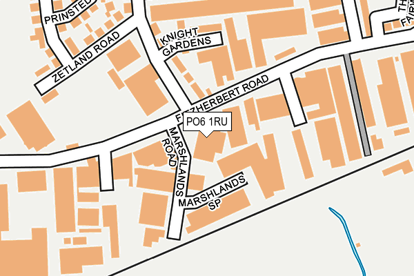
PO6 1RU lies on Fitzherbert Road in Portsmouth. PO6 1RU is located in the Drayton and Farlington electoral ward, within the unitary authority of Portsmouth and the English Parliamentary constituency of Portsmouth North. The Sub Integrated Care Board (ICB) Location is NHS Hampshire and Isle of Wight ICB - 10R and the police force is Hampshire. This postcode has been in use since January 1980.


GetTheData
Source: OS OpenMap – Local (Ordnance Survey)
Source: OS VectorMap District (Ordnance Survey)
Licence: Open Government Licence (requires attribution)
| Easting | 468032 |
| Northing | 105174 |
| Latitude | 50.842101 |
| Longitude | -1.035127 |
GetTheData
Source: Open Postcode Geo
Licence: Open Government Licence
| Street | Fitzherbert Road |
| Town/City | Portsmouth |
| Country | England |
| Postcode District | PO6 |
➜ See where PO6 is on a map ➜ Where is Portsmouth? | |
GetTheData
Source: Land Registry Price Paid Data
Licence: Open Government Licence
Elevation or altitude of PO6 1RU as distance above sea level:
| Metres | Feet | |
|---|---|---|
| Elevation | 0m | 0ft |
Elevation is measured from the approximate centre of the postcode, to the nearest point on an OS contour line from OS Terrain 50, which has contour spacing of ten vertical metres.
➜ How high above sea level am I? Find the elevation of your current position using your device's GPS.
GetTheData
Source: Open Postcode Elevation
Licence: Open Government Licence
| Ward | Drayton And Farlington |
| Constituency | Portsmouth North |
GetTheData
Source: ONS Postcode Database
Licence: Open Government Licence
49B, FITZHERBERT ROAD, PORTSMOUTH, PO6 1RU 1998 20 NOV £162,150 |
49B, FITZHERBERT ROAD, PORTSMOUTH, PO6 1RU 1996 25 MAR £117,000 |
GetTheData
Source: HM Land Registry Price Paid Data
Licence: Contains HM Land Registry data © Crown copyright and database right 2025. This data is licensed under the Open Government Licence v3.0.
| Marshlands Road (Fitzherbert Road) | Farlington | 69m |
| The Fairways (Fitzherbert Road) | Farlington | 297m |
| Sainsburys (Fitzherbert Road) | Farlington | 317m |
| Sainsburys | Farlington | 376m |
| Fitzherbert Road (Eastern Road) | Farlington | 401m |
| Cosham Station | 2.3km |
| Hilsea Station | 2.3km |
| Bedhampton Station | 3.1km |
GetTheData
Source: NaPTAN
Licence: Open Government Licence
Estimated total energy consumption in PO6 1RU by fuel type, 2015.
| Consumption (kWh) | 290,542 |
|---|---|
| Meter count | 11 |
| Mean (kWh/meter) | 26,413 |
| Median (kWh/meter) | 28,721 |
GetTheData
Source: Postcode level gas estimates: 2015 (experimental)
Source: Postcode level electricity estimates: 2015 (experimental)
Licence: Open Government Licence
GetTheData
Source: ONS Postcode Database
Licence: Open Government Licence


➜ Get more ratings from the Food Standards Agency
GetTheData
Source: Food Standards Agency
Licence: FSA terms & conditions
| Last Collection | |||
|---|---|---|---|
| Location | Mon-Fri | Sat | Distance |
| Waterworks Road | 17:30 | 12:00 | 375m |
| Old Farm Way | 17:30 | 12:00 | 437m |
| Galt Road | 17:00 | 11:45 | 598m |
GetTheData
Source: Dracos
Licence: Creative Commons Attribution-ShareAlike
| Risk of PO6 1RU flooding from rivers and sea | Low |
| ➜ PO6 1RU flood map | |
GetTheData
Source: Open Flood Risk by Postcode
Licence: Open Government Licence
The below table lists the International Territorial Level (ITL) codes (formerly Nomenclature of Territorial Units for Statistics (NUTS) codes) and Local Administrative Units (LAU) codes for PO6 1RU:
| ITL 1 Code | Name |
|---|---|
| TLJ | South East (England) |
| ITL 2 Code | Name |
| TLJ3 | Hampshire and Isle of Wight |
| ITL 3 Code | Name |
| TLJ31 | Portsmouth |
| LAU 1 Code | Name |
| E06000044 | Portsmouth |
GetTheData
Source: ONS Postcode Directory
Licence: Open Government Licence
The below table lists the Census Output Area (OA), Lower Layer Super Output Area (LSOA), and Middle Layer Super Output Area (MSOA) for PO6 1RU:
| Code | Name | |
|---|---|---|
| OA | E00086156 | |
| LSOA | E01017059 | Portsmouth 026A |
| MSOA | E02006821 | Portsmouth 026 |
GetTheData
Source: ONS Postcode Directory
Licence: Open Government Licence
| PO6 1TL | Marshlands Spur | 106m |
| PO6 1NH | Waterworks Road | 111m |
| PO6 1NW | Knight Gardens | 159m |
| PO6 1TT | Fitzherbert Spur | 211m |
| PO6 1NN | Zetland Road | 222m |
| PO6 1NS | Prinsted Crescent | 290m |
| PO6 1NR | Nutbourne Road | 316m |
| PO6 1NJ | Waterworks Road | 332m |
| PO6 1JS | Second Avenue | 335m |
| PO6 1RW | The Fairways | 338m |
GetTheData
Source: Open Postcode Geo; Land Registry Price Paid Data
Licence: Open Government Licence