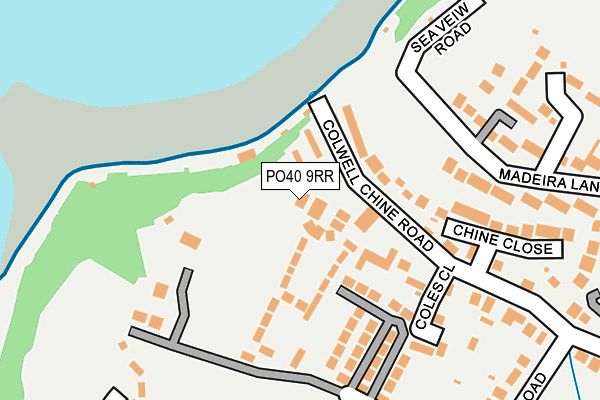
PO40 9RR is located in the Totland & Colwell electoral ward, within the unitary authority of Isle of Wight and the English Parliamentary constituency of Isle of Wight. The Sub Integrated Care Board (ICB) Location is NHS Hampshire and Isle of Wight ICB - D9Y0V and the police force is Hampshire. This postcode has been in use since February 1990.


GetTheData
Source: OS OpenMap – Local (Ordnance Survey)
Source: OS VectorMap District (Ordnance Survey)
Licence: Open Government Licence (requires attribution)
| Easting | 432714 |
| Northing | 87740 |
| Latitude | 50.688388 |
| Longitude | -1.538249 |
GetTheData
Source: Open Postcode Geo
Licence: Open Government Licence
| Country | England |
| Postcode District | PO40 |
➜ See where PO40 is on a map ➜ Where is Colwell? | |
GetTheData
Source: Land Registry Price Paid Data
Licence: Open Government Licence
Elevation or altitude of PO40 9RR as distance above sea level:
| Metres | Feet | |
|---|---|---|
| Elevation | 10m | 33ft |
Elevation is measured from the approximate centre of the postcode, to the nearest point on an OS contour line from OS Terrain 50, which has contour spacing of ten vertical metres.
➜ How high above sea level am I? Find the elevation of your current position using your device's GPS.
GetTheData
Source: Open Postcode Elevation
Licence: Open Government Licence
| Ward | Totland & Colwell |
| Constituency | Isle Of Wight |
GetTheData
Source: ONS Postcode Database
Licence: Open Government Licence
| Colwell Bay Car Park (Off Colwell Chine Road) | Colwell | 56m |
| Colwell Common (Colwell Road) | Colwell | 364m |
| Baptist Church (Colwell Road) | Colwell | 400m |
| Colwell Road (Colwell Lane) | Colwell | 420m |
| Coastguard Cottages (The Broadway) | Totland | 503m |
GetTheData
Source: NaPTAN
Licence: Open Government Licence
| Percentage of properties with Next Generation Access | 100.0% |
| Percentage of properties with Superfast Broadband | 100.0% |
| Percentage of properties with Ultrafast Broadband | 0.0% |
| Percentage of properties with Full Fibre Broadband | 0.0% |
Superfast Broadband is between 30Mbps and 300Mbps
Ultrafast Broadband is > 300Mbps
| Median download speed | 30.0Mbps |
| Average download speed | 28.2Mbps |
| Maximum download speed | 48.85Mbps |
| Median upload speed | 6.4Mbps |
| Average upload speed | 4.9Mbps |
| Maximum upload speed | 8.42Mbps |
| Percentage of properties unable to receive 2Mbps | 0.0% |
| Percentage of properties unable to receive 5Mbps | 0.0% |
| Percentage of properties unable to receive 10Mbps | 0.0% |
| Percentage of properties unable to receive 30Mbps | 0.0% |
GetTheData
Source: Ofcom
Licence: Ofcom Terms of Use (requires attribution)
Estimated total energy consumption in PO40 9RR by fuel type, 2015.
| Consumption (kWh) | 130,950 |
|---|---|
| Meter count | 22 |
| Mean (kWh/meter) | 5,952 |
| Median (kWh/meter) | 5,692 |
GetTheData
Source: Postcode level gas estimates: 2015 (experimental)
Source: Postcode level electricity estimates: 2015 (experimental)
Licence: Open Government Licence
GetTheData
Source: ONS Postcode Database
Licence: Open Government Licence


➜ Get more ratings from the Food Standards Agency
GetTheData
Source: Food Standards Agency
Licence: FSA terms & conditions
| Last Collection | |||
|---|---|---|---|
| Location | Mon-Fri | Sat | Distance |
| Colwell Bay | 17:00 | 10:45 | 56m |
| Colwell Common | 17:00 | 10:45 | 361m |
| Broadway Totland | 17:15 | 11:45 | 619m |
GetTheData
Source: Dracos
Licence: Creative Commons Attribution-ShareAlike
The below table lists the International Territorial Level (ITL) codes (formerly Nomenclature of Territorial Units for Statistics (NUTS) codes) and Local Administrative Units (LAU) codes for PO40 9RR:
| ITL 1 Code | Name |
|---|---|
| TLJ | South East (England) |
| ITL 2 Code | Name |
| TLJ3 | Hampshire and Isle of Wight |
| ITL 3 Code | Name |
| TLJ34 | Isle of Wight |
| LAU 1 Code | Name |
| E06000046 | Isle of Wight |
GetTheData
Source: ONS Postcode Directory
Licence: Open Government Licence
The below table lists the Census Output Area (OA), Lower Layer Super Output Area (LSOA), and Middle Layer Super Output Area (MSOA) for PO40 9RR:
| Code | Name | |
|---|---|---|
| OA | E00087684 | |
| LSOA | E01017362 | Isle of Wight 012G |
| MSOA | E02003592 | Isle of Wight 012 |
GetTheData
Source: ONS Postcode Directory
Licence: Open Government Licence
| PO39 0DA | Fort Warden Road | 75m |
| PO40 9NP | Colwell Chine Road | 94m |
| PO40 9PL | Coles Close | 152m |
| PO40 9NS | Chine Close | 197m |
| PO40 9FH | Madeira Lane | 237m |
| PO39 0DD | Colwell Common Road | 244m |
| PO40 9SP | Madeira Lane | 255m |
| PO39 0JJ | Conway Lane | 268m |
| PO40 9NR | Colwell Chine Road | 309m |
| PO39 0AQ | Hurst Point View | 317m |
GetTheData
Source: Open Postcode Geo; Land Registry Price Paid Data
Licence: Open Government Licence