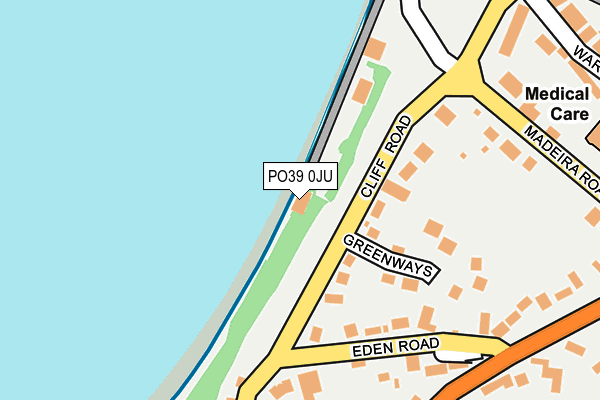
PO39 0JU is located in the Totland & Colwell electoral ward, within the unitary authority of Isle of Wight and the English Parliamentary constituency of Isle of Wight. The Sub Integrated Care Board (ICB) Location is NHS Hampshire and Isle of Wight ICB - D9Y0V and the police force is Hampshire. This postcode has been in use since April 1987.


GetTheData
Source: OS OpenMap – Local (Ordnance Survey)
Source: OS VectorMap District (Ordnance Survey)
Licence: Open Government Licence (requires attribution)
| Easting | 432193 |
| Northing | 86870 |
| Latitude | 50.680603 |
| Longitude | -1.545708 |
GetTheData
Source: Open Postcode Geo
Licence: Open Government Licence
| Country | England |
| Postcode District | PO39 |
➜ See where PO39 is on a map ➜ Where is Totland? | |
GetTheData
Source: Land Registry Price Paid Data
Licence: Open Government Licence
Elevation or altitude of PO39 0JU as distance above sea level:
| Metres | Feet | |
|---|---|---|
| Elevation | 10m | 33ft |
Elevation is measured from the approximate centre of the postcode, to the nearest point on an OS contour line from OS Terrain 50, which has contour spacing of ten vertical metres.
➜ How high above sea level am I? Find the elevation of your current position using your device's GPS.
GetTheData
Source: Open Postcode Elevation
Licence: Open Government Licence
| Ward | Totland & Colwell |
| Constituency | Isle Of Wight |
GetTheData
Source: ONS Postcode Database
Licence: Open Government Licence
| Madeira Road (Cliff Road) | Totland | 169m |
| War Memorial (The Broadway) | Totland | 368m |
| War Memorial (The Broadway) | Totland | 386m |
| St Saviours Road (Weston Road) | Totland | 387m |
| Church Hill | Totland | 394m |
GetTheData
Source: NaPTAN
Licence: Open Government Licence
GetTheData
Source: ONS Postcode Database
Licence: Open Government Licence


➜ Get more ratings from the Food Standards Agency
GetTheData
Source: Food Standards Agency
Licence: FSA terms & conditions
| Last Collection | |||
|---|---|---|---|
| Location | Mon-Fri | Sat | Distance |
| Madeira Road | 16:45 | 10:30 | 267m |
| Church Hill Road | 16:30 | 10:45 | 335m |
| Totland Post Office | 17:15 | 11:45 | 381m |
GetTheData
Source: Dracos
Licence: Creative Commons Attribution-ShareAlike
The below table lists the International Territorial Level (ITL) codes (formerly Nomenclature of Territorial Units for Statistics (NUTS) codes) and Local Administrative Units (LAU) codes for PO39 0JU:
| ITL 1 Code | Name |
|---|---|
| TLJ | South East (England) |
| ITL 2 Code | Name |
| TLJ3 | Hampshire and Isle of Wight |
| ITL 3 Code | Name |
| TLJ34 | Isle of Wight |
| LAU 1 Code | Name |
| E06000046 | Isle of Wight |
GetTheData
Source: ONS Postcode Directory
Licence: Open Government Licence
The below table lists the Census Output Area (OA), Lower Layer Super Output Area (LSOA), and Middle Layer Super Output Area (MSOA) for PO39 0JU:
| Code | Name | |
|---|---|---|
| OA | E00087683 | |
| LSOA | E01017361 | Isle of Wight 012F |
| MSOA | E02003592 | Isle of Wight 012 |
GetTheData
Source: ONS Postcode Directory
Licence: Open Government Licence
| PO39 0EH | Cliff Road | 79m |
| PO39 0BQ | The Beach | 134m |
| PO39 0ED | Greenways | 153m |
| PO39 0BH | Cliff Road | 168m |
| PO39 0EN | Cliff Road | 191m |
| PO39 0EJ | Eden Road | 194m |
| PO39 0HP | Eden Place | 222m |
| PO39 0EU | Church Hill | 273m |
| PO39 0AR | Ward Road | 273m |
| PO39 0EL | Heatherwood Park Road | 302m |
GetTheData
Source: Open Postcode Geo; Land Registry Price Paid Data
Licence: Open Government Licence