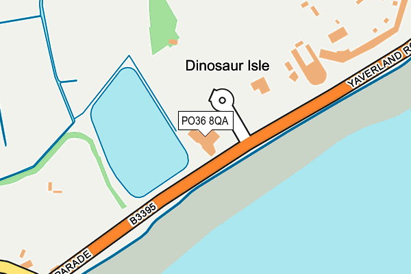
PO36 8QA is located in the Sandown North electoral ward, within the unitary authority of Isle of Wight and the English Parliamentary constituency of Isle of Wight. The Sub Integrated Care Board (ICB) Location is NHS Hampshire and Isle of Wight ICB - D9Y0V and the police force is Hampshire. This postcode has been in use since January 1980.


GetTheData
Source: OS OpenMap – Local (Ordnance Survey)
Source: OS VectorMap District (Ordnance Survey)
Licence: Open Government Licence (requires attribution)
| Easting | 460774 |
| Northing | 84817 |
| Latitude | 50.659854 |
| Longitude | -1.141540 |
GetTheData
Source: Open Postcode Geo
Licence: Open Government Licence
| Country | England |
| Postcode District | PO36 |
➜ See where PO36 is on a map | |
GetTheData
Source: Land Registry Price Paid Data
Licence: Open Government Licence
Elevation or altitude of PO36 8QA as distance above sea level:
| Metres | Feet | |
|---|---|---|
| Elevation | 10m | 33ft |
Elevation is measured from the approximate centre of the postcode, to the nearest point on an OS contour line from OS Terrain 50, which has contour spacing of ten vertical metres.
➜ How high above sea level am I? Find the elevation of your current position using your device's GPS.
GetTheData
Source: Open Postcode Elevation
Licence: Open Government Licence
| Ward | Sandown North |
| Constituency | Isle Of Wight |
GetTheData
Source: ONS Postcode Database
Licence: Open Government Licence
| Dinosaur Isle (Culver Parade) | Yaverland | 55m |
| Grand Hotel (Culver Parade) | Sandown | 71m |
| Grand Hotel (Culver Parade) | Sandown | 204m |
| Isle Of Wight Zoo (Yaverland Road) | Yaverland | 269m |
| Wight City (Culver Parade) | Sandown | 390m |
| Sandown Station | 1.5km |
| Brading Station | 2.1km |
| Lake (Isle of Wight) Station | 2.3km |
GetTheData
Source: NaPTAN
Licence: Open Government Licence
GetTheData
Source: ONS Postcode Database
Licence: Open Government Licence


➜ Get more ratings from the Food Standards Agency
GetTheData
Source: Food Standards Agency
Licence: FSA terms & conditions
| Last Collection | |||
|---|---|---|---|
| Location | Mon-Fri | Sat | Distance |
| Culver Way | 14:00 | 10:30 | 558m |
| Avenue Road Post Office | 17:00 | 12:00 | 668m |
| Lower Avenue Road | 17:00 | 11:30 | 710m |
GetTheData
Source: Dracos
Licence: Creative Commons Attribution-ShareAlike
The below table lists the International Territorial Level (ITL) codes (formerly Nomenclature of Territorial Units for Statistics (NUTS) codes) and Local Administrative Units (LAU) codes for PO36 8QA:
| ITL 1 Code | Name |
|---|---|
| TLJ | South East (England) |
| ITL 2 Code | Name |
| TLJ3 | Hampshire and Isle of Wight |
| ITL 3 Code | Name |
| TLJ34 | Isle of Wight |
| LAU 1 Code | Name |
| E06000046 | Isle of Wight |
GetTheData
Source: ONS Postcode Directory
Licence: Open Government Licence
The below table lists the Census Output Area (OA), Lower Layer Super Output Area (LSOA), and Middle Layer Super Output Area (MSOA) for PO36 8QA:
| Code | Name | |
|---|---|---|
| OA | E00087609 | |
| LSOA | E01017347 | Isle of Wight 014B |
| MSOA | E02003594 | Isle of Wight 014 |
GetTheData
Source: ONS Postcode Directory
Licence: Open Government Licence
| PO36 8QF | Yaverland Close | 434m |
| PO36 8QB | Yaverland Road | 455m |
| PO36 8EU | Marsh Close | 495m |
| PO36 8AT | Culver Parade | 501m |
| PO36 8AU | Fort Street | 537m |
| PO36 8QH | Whitecliff Close | 542m |
| PO36 8QE | Meadow Way | 548m |
| PO36 8QD | Meadow Way | 579m |
| PO36 8BH | Fort Mews | 582m |
| PO36 8QQ | Redcliff Close | 589m |
GetTheData
Source: Open Postcode Geo; Land Registry Price Paid Data
Licence: Open Government Licence