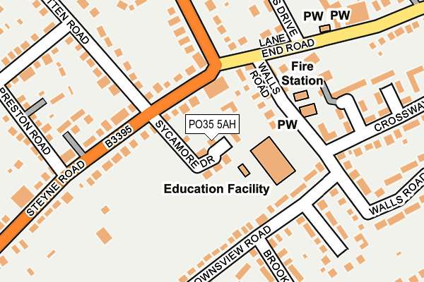
PO35 5AH is located in the Bembridge electoral ward, within the unitary authority of Isle of Wight and the English Parliamentary constituency of Isle of Wight. The Sub Integrated Care Board (ICB) Location is NHS Hampshire and Isle of Wight ICB - D9Y0V and the police force is Hampshire. This postcode has been in use since June 2017.


GetTheData
Source: OS OpenMap – Local (Ordnance Survey)
Source: OS VectorMap District (Ordnance Survey)
Licence: Open Government Licence (requires attribution)
| Easting | 464854 |
| Northing | 87644 |
| Latitude | 50.684834 |
| Longitude | -1.083329 |
GetTheData
Source: Open Postcode Geo
Licence: Open Government Licence
| Country | England |
| Postcode District | PO35 |
➜ See where PO35 is on a map ➜ Where is Bembridge? | |
GetTheData
Source: Land Registry Price Paid Data
Licence: Open Government Licence
| Ward | Bembridge |
| Constituency | Isle Of Wight |
GetTheData
Source: ONS Postcode Database
Licence: Open Government Licence
| Windmill Hotel (Steyne Road) | Bembridge | 112m |
| Fire Station (Walls Road) | Bembridge | 137m |
| Windmill Hotel (Steyne Road) | Bembridge | 138m |
| Foreland Road | Bembridge | 196m |
| Lane End (Lane End Road) | Bembridge | 223m |
| Brading Station | 4km |
GetTheData
Source: NaPTAN
Licence: Open Government Licence
| Percentage of properties with Next Generation Access | 100.0% |
| Percentage of properties with Superfast Broadband | 100.0% |
| Percentage of properties with Ultrafast Broadband | 0.0% |
| Percentage of properties with Full Fibre Broadband | 0.0% |
Superfast Broadband is between 30Mbps and 300Mbps
Ultrafast Broadband is > 300Mbps
| Median download speed | 19.0Mbps |
| Average download speed | 37.4Mbps |
| Maximum download speed | 80.00Mbps |
| Median upload speed | 1.2Mbps |
| Average upload speed | 7.5Mbps |
| Maximum upload speed | 20.00Mbps |
| Percentage of properties unable to receive 2Mbps | 0.0% |
| Percentage of properties unable to receive 5Mbps | 0.0% |
| Percentage of properties unable to receive 10Mbps | 0.0% |
| Percentage of properties unable to receive 30Mbps | 0.0% |
GetTheData
Source: Ofcom
Licence: Ofcom Terms of Use (requires attribution)
GetTheData
Source: ONS Postcode Database
Licence: Open Government Licence


➜ Get more ratings from the Food Standards Agency
GetTheData
Source: Food Standards Agency
Licence: FSA terms & conditions
| Last Collection | |||
|---|---|---|---|
| Location | Mon-Fri | Sat | Distance |
| Lane End News | 17:00 | 10:30 | 294m |
| Howgate Lane | 17:00 | 10:30 | 324m |
| Bembridge Post Office | 17:00 | 10:45 | 356m |
GetTheData
Source: Dracos
Licence: Creative Commons Attribution-ShareAlike
The below table lists the International Territorial Level (ITL) codes (formerly Nomenclature of Territorial Units for Statistics (NUTS) codes) and Local Administrative Units (LAU) codes for PO35 5AH:
| ITL 1 Code | Name |
|---|---|
| TLJ | South East (England) |
| ITL 2 Code | Name |
| TLJ3 | Hampshire and Isle of Wight |
| ITL 3 Code | Name |
| TLJ34 | Isle of Wight |
| LAU 1 Code | Name |
| E06000046 | Isle of Wight |
GetTheData
Source: ONS Postcode Directory
Licence: Open Government Licence
The below table lists the Census Output Area (OA), Lower Layer Super Output Area (LSOA), and Middle Layer Super Output Area (MSOA) for PO35 5AH:
| Code | Name | |
|---|---|---|
| OA | E00087300 | |
| LSOA | E01017285 | Isle of Wight 010B |
| MSOA | E02003590 | Isle of Wight 010 |
GetTheData
Source: ONS Postcode Directory
Licence: Open Government Licence
| PO35 5RH | Walls Road | 96m |
| PO35 5QS | Downs View Road | 96m |
| PO35 5UH | Steyne Road | 100m |
| PO35 5XJ | Isenhurst Court | 125m |
| PO35 5XH | Steyne Road | 150m |
| PO35 5QT | Downs View Road | 167m |
| PO35 5UL | Steyne Road | 179m |
| PO35 5RD | Walls Road | 179m |
| PO35 5RL | Rolfs Close | 190m |
| PO35 5AD | Rosemead Place | 192m |
GetTheData
Source: Open Postcode Geo; Land Registry Price Paid Data
Licence: Open Government Licence