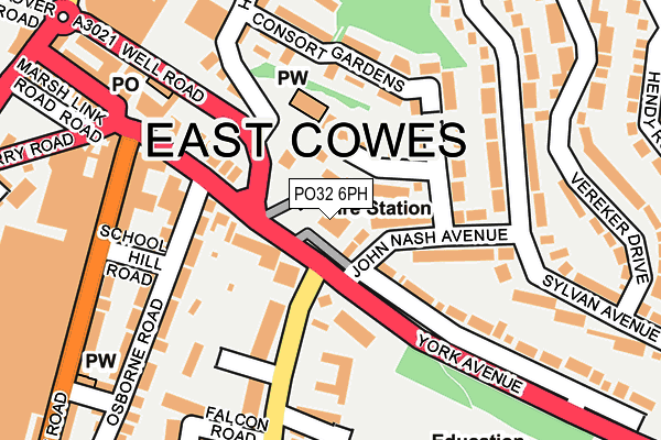
PO32 6PH is located in the East Cowes electoral ward, within the unitary authority of Isle of Wight and the English Parliamentary constituency of Isle of Wight. The Sub Integrated Care Board (ICB) Location is NHS Hampshire and Isle of Wight ICB - D9Y0V and the police force is Hampshire. This postcode has been in use since March 2003.


GetTheData
Source: OS OpenMap – Local (Ordnance Survey)
Source: OS VectorMap District (Ordnance Survey)
Licence: Open Government Licence (requires attribution)
| Easting | 450487 |
| Northing | 95501 |
| Latitude | 50.756917 |
| Longitude | -1.285617 |
GetTheData
Source: Open Postcode Geo
Licence: Open Government Licence
| Country | England |
| Postcode District | PO32 |
➜ See where PO32 is on a map ➜ Where is East Cowes? | |
GetTheData
Source: Land Registry Price Paid Data
Licence: Open Government Licence
Elevation or altitude of PO32 6PH as distance above sea level:
| Metres | Feet | |
|---|---|---|
| Elevation | 10m | 33ft |
Elevation is measured from the approximate centre of the postcode, to the nearest point on an OS contour line from OS Terrain 50, which has contour spacing of ten vertical metres.
➜ How high above sea level am I? Find the elevation of your current position using your device's GPS.
GetTheData
Source: Open Postcode Elevation
Licence: Open Government Licence
| Ward | East Cowes |
| Constituency | Isle Of Wight |
GetTheData
Source: ONS Postcode Database
Licence: Open Government Licence
| John Nash Avenue (York Avenue) | East Cowes | 85m |
| Health Centre (York Avenue) | East Cowes | 110m |
| John Nash Avenue | East Cowes | 143m |
| Frank James Hospital (Adelaide Grove) | East Cowes | 148m |
| Frank James Hospital (Adelaide Grove) | East Cowes | 182m |
GetTheData
Source: NaPTAN
Licence: Open Government Licence
GetTheData
Source: ONS Postcode Database
Licence: Open Government Licence


➜ Get more ratings from the Food Standards Agency
GetTheData
Source: Food Standards Agency
Licence: FSA terms & conditions
| Last Collection | |||
|---|---|---|---|
| Location | Mon-Fri | Sat | Distance |
| Sylvan Avenue | 17:30 | 11:45 | 198m |
| Well Road Post Office | 17:30 | 11:45 | 202m |
| Well Road Post Office | 17:30 | 11:45 | 204m |
GetTheData
Source: Dracos
Licence: Creative Commons Attribution-ShareAlike
The below table lists the International Territorial Level (ITL) codes (formerly Nomenclature of Territorial Units for Statistics (NUTS) codes) and Local Administrative Units (LAU) codes for PO32 6PH:
| ITL 1 Code | Name |
|---|---|
| TLJ | South East (England) |
| ITL 2 Code | Name |
| TLJ3 | Hampshire and Isle of Wight |
| ITL 3 Code | Name |
| TLJ34 | Isle of Wight |
| LAU 1 Code | Name |
| E06000046 | Isle of Wight |
GetTheData
Source: ONS Postcode Directory
Licence: Open Government Licence
The below table lists the Census Output Area (OA), Lower Layer Super Output Area (LSOA), and Middle Layer Super Output Area (MSOA) for PO32 6PH:
| Code | Name | |
|---|---|---|
| OA | E00087407 | |
| LSOA | E01017307 | Isle of Wight 003A |
| MSOA | E02003583 | Isle of Wight 003 |
GetTheData
Source: ONS Postcode Directory
Licence: Open Government Licence
| PO32 6PP | St James Close | 48m |
| PO32 6PJ | John Nash Avenue | 61m |
| PO32 6RT | York Avenue | 71m |
| PO32 6RS | York Avenue | 72m |
| PO32 6PL | Oak Tree Way | 128m |
| PO32 6RX | Osborne Road | 129m |
| PO32 6PR | John Nash Avenue | 138m |
| PO32 6BY | Adelaide Grove | 140m |
| PO32 6PS | Sylvan Avenue | 157m |
| PO32 6FT | Consort Gardens | 159m |
GetTheData
Source: Open Postcode Geo; Land Registry Price Paid Data
Licence: Open Government Licence