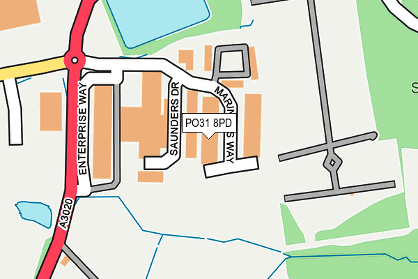
PO31 8PD lies on Mariners Way in Cowes. PO31 8PD is located in the Cowes South & Northwood electoral ward, within the unitary authority of Isle of Wight and the English Parliamentary constituency of Isle of Wight. The Sub Integrated Care Board (ICB) Location is NHS Hampshire and Isle of Wight ICB - D9Y0V and the police force is Hampshire. This postcode has been in use since September 2003.


GetTheData
Source: OS OpenMap – Local (Ordnance Survey)
Source: OS VectorMap District (Ordnance Survey)
Licence: Open Government Licence (requires attribution)
| Easting | 449319 |
| Northing | 94581 |
| Latitude | 50.748733 |
| Longitude | -1.302287 |
GetTheData
Source: Open Postcode Geo
Licence: Open Government Licence
| Street | Mariners Way |
| Town/City | Cowes |
| Country | England |
| Postcode District | PO31 |
➜ See where PO31 is on a map ➜ Where is Cowes? | |
GetTheData
Source: Land Registry Price Paid Data
Licence: Open Government Licence
Elevation or altitude of PO31 8PD as distance above sea level:
| Metres | Feet | |
|---|---|---|
| Elevation | 50m | 164ft |
Elevation is measured from the approximate centre of the postcode, to the nearest point on an OS contour line from OS Terrain 50, which has contour spacing of ten vertical metres.
➜ How high above sea level am I? Find the elevation of your current position using your device's GPS.
GetTheData
Source: Open Postcode Elevation
Licence: Open Government Licence
| Ward | Cowes South & Northwood |
| Constituency | Isle Of Wight |
GetTheData
Source: ONS Postcode Database
Licence: Open Government Licence
| Somerton Park-and-ride | Cowes | 196m |
| Aldi (Three Gates Road) | Cowes | 301m |
| Northwood Cemetery (Newport Road) | Cowes | 319m |
| Northwood Cemetery (Newport Road) | Cowes | 324m |
| Aldi (Three Gate Road) | Cowes | 332m |
GetTheData
Source: NaPTAN
Licence: Open Government Licence
GetTheData
Source: ONS Postcode Database
Licence: Open Government Licence


➜ Get more ratings from the Food Standards Agency
GetTheData
Source: Food Standards Agency
Licence: FSA terms & conditions
| Last Collection | |||
|---|---|---|---|
| Location | Mon-Fri | Sat | Distance |
| Somerton | 17:15 | 10:30 | 374m |
| Milton Road | 17:15 | 12:00 | 542m |
| Seaview Road | 16:45 | 11:30 | 671m |
GetTheData
Source: Dracos
Licence: Creative Commons Attribution-ShareAlike
The below table lists the International Territorial Level (ITL) codes (formerly Nomenclature of Territorial Units for Statistics (NUTS) codes) and Local Administrative Units (LAU) codes for PO31 8PD:
| ITL 1 Code | Name |
|---|---|
| TLJ | South East (England) |
| ITL 2 Code | Name |
| TLJ3 | Hampshire and Isle of Wight |
| ITL 3 Code | Name |
| TLJ34 | Isle of Wight |
| LAU 1 Code | Name |
| E06000046 | Isle of Wight |
GetTheData
Source: ONS Postcode Directory
Licence: Open Government Licence
The below table lists the Census Output Area (OA), Lower Layer Super Output Area (LSOA), and Middle Layer Super Output Area (MSOA) for PO31 8PD:
| Code | Name | |
|---|---|---|
| OA | E00087513 | |
| LSOA | E01017329 | Isle of Wight 002E |
| MSOA | E02003582 | Isle of Wight 002 |
GetTheData
Source: ONS Postcode Directory
Licence: Open Government Licence
| PO31 8PA | Somerton Industrial Park | 93m |
| PO31 8AP | Enterprise Way | 154m |
| PO31 7ER | Newport Road | 301m |
| PO31 7ES | Love Lane | 349m |
| PO31 7HD | Ash Grove | 361m |
| PO31 7HS | Ash Grove | 364m |
| PO31 7EP | Mill Hill Road | 365m |
| PO31 8QZ | Nelson Court | 397m |
| PO31 7EW | Mill Hill Road | 403m |
| PO31 8QX | Nelson Drive | 425m |
GetTheData
Source: Open Postcode Geo; Land Registry Price Paid Data
Licence: Open Government Licence