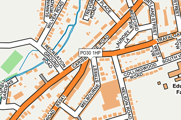
PO30 1HP is located in the Mountjoy & Shide electoral ward, within the unitary authority of Isle of Wight and the English Parliamentary constituency of Isle of Wight. The Sub Integrated Care Board (ICB) Location is NHS Hampshire and Isle of Wight ICB - D9Y0V and the police force is Hampshire. This postcode has been in use since October 1984.


GetTheData
Source: OS OpenMap – Local (Ordnance Survey)
Source: OS VectorMap District (Ordnance Survey)
Licence: Open Government Licence (requires attribution)
| Easting | 449336 |
| Northing | 88669 |
| Latitude | 50.695582 |
| Longitude | -1.302845 |
GetTheData
Source: Open Postcode Geo
Licence: Open Government Licence
| Country | England |
| Postcode District | PO30 |
➜ See where PO30 is on a map ➜ Where is Newport? | |
GetTheData
Source: Land Registry Price Paid Data
Licence: Open Government Licence
Elevation or altitude of PO30 1HP as distance above sea level:
| Metres | Feet | |
|---|---|---|
| Elevation | 10m | 33ft |
Elevation is measured from the approximate centre of the postcode, to the nearest point on an OS contour line from OS Terrain 50, which has contour spacing of ten vertical metres.
➜ How high above sea level am I? Find the elevation of your current position using your device's GPS.
GetTheData
Source: Open Postcode Elevation
Licence: Open Government Licence
| Ward | Mountjoy & Shide |
| Constituency | Isle Of Wight |
GetTheData
Source: ONS Postcode Database
Licence: Open Government Licence
| Simeon Monument (Carisbrooke) | Newport | 28m |
| Simeon Monument (Carisbrooke Road) | Newport | 67m |
| Lukely Terrace (Carisbrooke Road) | Newport | 323m |
| Lukely Terrace | Newport | 386m |
| Wellington Road Bottom (Wellington Road) | Newport | 390m |
GetTheData
Source: NaPTAN
Licence: Open Government Licence
GetTheData
Source: ONS Postcode Database
Licence: Open Government Licence


➜ Get more ratings from the Food Standards Agency
GetTheData
Source: Food Standards Agency
Licence: FSA terms & conditions
| Last Collection | |||
|---|---|---|---|
| Location | Mon-Fri | Sat | Distance |
| Castle Road | 17:00 | 12:00 | 28m |
| The Mall | 17:45 | 12:15 | 201m |
| Winston Road | 17:00 | 12:15 | 222m |
GetTheData
Source: Dracos
Licence: Creative Commons Attribution-ShareAlike
The below table lists the International Territorial Level (ITL) codes (formerly Nomenclature of Territorial Units for Statistics (NUTS) codes) and Local Administrative Units (LAU) codes for PO30 1HP:
| ITL 1 Code | Name |
|---|---|
| TLJ | South East (England) |
| ITL 2 Code | Name |
| TLJ3 | Hampshire and Isle of Wight |
| ITL 3 Code | Name |
| TLJ34 | Isle of Wight |
| LAU 1 Code | Name |
| E06000046 | Isle of Wight |
GetTheData
Source: ONS Postcode Directory
Licence: Open Government Licence
The below table lists the Census Output Area (OA), Lower Layer Super Output Area (LSOA), and Middle Layer Super Output Area (MSOA) for PO30 1HP:
| Code | Name | |
|---|---|---|
| OA | E00087481 | |
| LSOA | E01017322 | Isle of Wight 011E |
| MSOA | E02003591 | Isle of Wight 011 |
GetTheData
Source: ONS Postcode Directory
Licence: Open Government Licence
| PO30 1DU | Carisbrooke Road | 4m |
| PO30 1DB | Carisbrooke Road | 45m |
| PO30 1QU | Trafalgar Road | 51m |
| PO30 1QX | Melbourne Street | 57m |
| PO30 1RA | Canberra Terrace | 65m |
| PO30 1QT | Nelson Road | 79m |
| PO30 1DT | Castle Road | 88m |
| PO30 1QL | Laundry Lane | 109m |
| PO30 1DA | Carisbrooke Road | 122m |
| PO30 1BZ | Carisbrooke Road | 124m |
GetTheData
Source: Open Postcode Geo; Land Registry Price Paid Data
Licence: Open Government Licence