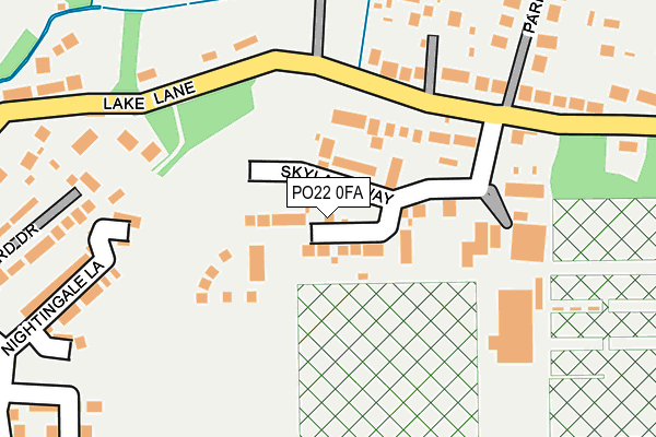
PO22 0FA is located in the Barnham electoral ward, within the local authority district of Arun and the English Parliamentary constituency of Arundel and South Downs. The Sub Integrated Care Board (ICB) Location is NHS Sussex ICB - 70F and the police force is Sussex. This postcode has been in use since July 2017.


GetTheData
Source: OS OpenMap – Local (Ordnance Survey)
Source: OS VectorMap District (Ordnance Survey)
Licence: Open Government Licence (requires attribution)
| Easting | 496614 |
| Northing | 104615 |
| Latitude | 50.833006 |
| Longitude | -0.629415 |
GetTheData
Source: Open Postcode Geo
Licence: Open Government Licence
| Country | England |
| Postcode District | PO22 |
➜ See where PO22 is on a map ➜ Where is Barnham? | |
GetTheData
Source: Land Registry Price Paid Data
Licence: Open Government Licence
| Ward | Barnham |
| Constituency | Arundel And South Downs |
GetTheData
Source: ONS Postcode Database
Licence: Open Government Licence
2023 26 SEP £700,000 |
2023 30 JUN £515,000 |
2022 24 JUN £675,000 |
2022 25 MAR £655,000 |
2022 9 FEB £520,000 |
2021 26 MAR £465,000 |
2021 17 MAR £505,000 |
22, SKYLARK WAY, BARNHAM, BOGNOR REGIS, PO22 0FA 2021 22 FEB £555,000 |
2020 17 DEC £470,000 |
2020 9 NOV £412,500 |
GetTheData
Source: HM Land Registry Price Paid Data
Licence: Contains HM Land Registry data © Crown copyright and database right 2025. This data is licensed under the Open Government Licence v3.0.
| Kingsmill Road (Barnham Lane) | Barnham | 451m |
| Kingsmill Road (Barnham Lane) | Barnham | 457m |
| Kingsmill Road | Barnham | 504m |
| Lake Lane | Barnham | 548m |
| Lake Lane | Barnham | 549m |
| Barnham Station | 0.8km |
| Ford Station | 3.6km |
GetTheData
Source: NaPTAN
Licence: Open Government Licence
| Percentage of properties with Next Generation Access | 100.0% |
| Percentage of properties with Superfast Broadband | 100.0% |
| Percentage of properties with Ultrafast Broadband | 96.2% |
| Percentage of properties with Full Fibre Broadband | 96.2% |
Superfast Broadband is between 30Mbps and 300Mbps
Ultrafast Broadband is > 300Mbps
| Percentage of properties unable to receive 2Mbps | 0.0% |
| Percentage of properties unable to receive 5Mbps | 0.0% |
| Percentage of properties unable to receive 10Mbps | 0.0% |
| Percentage of properties unable to receive 30Mbps | 0.0% |
GetTheData
Source: Ofcom
Licence: Ofcom Terms of Use (requires attribution)
GetTheData
Source: ONS Postcode Database
Licence: Open Government Licence


➜ Get more ratings from the Food Standards Agency
GetTheData
Source: Food Standards Agency
Licence: FSA terms & conditions
| Last Collection | |||
|---|---|---|---|
| Location | Mon-Fri | Sat | Distance |
| Barnham Post Office | 16:15 | 11:00 | 829m |
| Church Lane | 16:35 | 07:45 | 1,307m |
| Walberton Post Office | 16:45 | 09:40 | 1,465m |
GetTheData
Source: Dracos
Licence: Creative Commons Attribution-ShareAlike
The below table lists the International Territorial Level (ITL) codes (formerly Nomenclature of Territorial Units for Statistics (NUTS) codes) and Local Administrative Units (LAU) codes for PO22 0FA:
| ITL 1 Code | Name |
|---|---|
| TLJ | South East (England) |
| ITL 2 Code | Name |
| TLJ2 | Surrey, East and West Sussex |
| ITL 3 Code | Name |
| TLJ27 | West Sussex (South West) |
| LAU 1 Code | Name |
| E07000224 | Arun |
GetTheData
Source: ONS Postcode Directory
Licence: Open Government Licence
The below table lists the Census Output Area (OA), Lower Layer Super Output Area (LSOA), and Middle Layer Super Output Area (MSOA) for PO22 0FA:
| Code | Name | |
|---|---|---|
| OA | E00160085 | |
| LSOA | E01031393 | Arun 003A |
| MSOA | E02006544 | Arun 003 |
GetTheData
Source: ONS Postcode Directory
Licence: Open Government Licence
| PO22 0AE | Lake Lane | 130m |
| PO22 0AG | Rose Terrace | 181m |
| PO22 0AJ | Lake Lane | 264m |
| PO22 0AQ | Park Road | 266m |
| PO22 0AD | Lake Lane | 270m |
| PO22 0BZ | Lake Lane | 276m |
| PO22 0AB | Halliford Drive | 306m |
| PO22 0JT | Foxes Croft | 468m |
| PO22 0JF | Goodacres | 483m |
| PO22 0JB | Lake Lane | 485m |
GetTheData
Source: Open Postcode Geo; Land Registry Price Paid Data
Licence: Open Government Licence