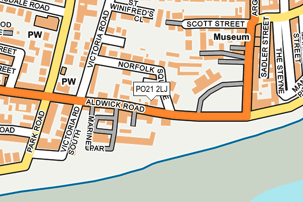
PO21 2LJ is located in the Marine electoral ward, within the local authority district of Arun and the English Parliamentary constituency of Bognor Regis and Littlehampton. The Sub Integrated Care Board (ICB) Location is NHS Sussex ICB - 70F and the police force is Sussex. This postcode has been in use since February 1990.


GetTheData
Source: OS OpenMap – Local (Ordnance Survey)
Source: OS VectorMap District (Ordnance Survey)
Licence: Open Government Licence (requires attribution)
| Easting | 493034 |
| Northing | 98779 |
| Latitude | 50.781135 |
| Longitude | -0.681736 |
GetTheData
Source: Open Postcode Geo
Licence: Open Government Licence
| Country | England |
| Postcode District | PO21 |
➜ See where PO21 is on a map ➜ Where is Bognor Regis? | |
GetTheData
Source: Land Registry Price Paid Data
Licence: Open Government Licence
Elevation or altitude of PO21 2LJ as distance above sea level:
| Metres | Feet | |
|---|---|---|
| Elevation | 10m | 33ft |
Elevation is measured from the approximate centre of the postcode, to the nearest point on an OS contour line from OS Terrain 50, which has contour spacing of ten vertical metres.
➜ How high above sea level am I? Find the elevation of your current position using your device's GPS.
GetTheData
Source: Open Postcode Elevation
Licence: Open Government Licence
| Ward | Marine |
| Constituency | Bognor Regis And Littlehampton |
GetTheData
Source: ONS Postcode Database
Licence: Open Government Licence
| Royal Norfolk Hotel (Aldwick Road) | Bognor Regis | 122m |
| Royal Norfolk Hotel (Aldwick Road) | Bognor Regis | 131m |
| Scott Street (West Street) | Bognor Regis | 229m |
| Aldwick Post Office (Aldwick Road) | Aldwick | 249m |
| Aldwick Post Office (Aldwick Road) | Aldwick | 339m |
| Bognor Regis Station | 0.7km |
GetTheData
Source: NaPTAN
Licence: Open Government Licence
GetTheData
Source: ONS Postcode Database
Licence: Open Government Licence


➜ Get more ratings from the Food Standards Agency
GetTheData
Source: Food Standards Agency
Licence: FSA terms & conditions
| Last Collection | |||
|---|---|---|---|
| Location | Mon-Fri | Sat | Distance |
| West Street | 17:30 | 11:30 | 223m |
| Victoria Park Post Office | 18:20 | 11:30 | 299m |
| Southdown Road | 17:30 | 11:30 | 339m |
GetTheData
Source: Dracos
Licence: Creative Commons Attribution-ShareAlike
The below table lists the International Territorial Level (ITL) codes (formerly Nomenclature of Territorial Units for Statistics (NUTS) codes) and Local Administrative Units (LAU) codes for PO21 2LJ:
| ITL 1 Code | Name |
|---|---|
| TLJ | South East (England) |
| ITL 2 Code | Name |
| TLJ2 | Surrey, East and West Sussex |
| ITL 3 Code | Name |
| TLJ27 | West Sussex (South West) |
| LAU 1 Code | Name |
| E07000224 | Arun |
GetTheData
Source: ONS Postcode Directory
Licence: Open Government Licence
The below table lists the Census Output Area (OA), Lower Layer Super Output Area (LSOA), and Middle Layer Super Output Area (MSOA) for PO21 2LJ:
| Code | Name | |
|---|---|---|
| OA | E00160293 | |
| LSOA | E01031437 | Arun 017E |
| MSOA | E02006558 | Arun 017 |
GetTheData
Source: ONS Postcode Directory
Licence: Open Government Licence
| PO21 2JB | Norfolk Close | 29m |
| PO21 2LG | Aldwick Road | 37m |
| PO21 2LL | Rock Gardens | 48m |
| PO21 2LP | Aldwick Road | 49m |
| PO21 2JD | Norfolk Square | 49m |
| PO21 2LN | Aldwick Road | 58m |
| PO21 2DJ | Norfolk Square | 75m |
| PO21 2JA | Norfolk Square | 82m |
| PO21 2LD | Norfolk Square | 89m |
| PO21 2LE | Rock Gardens | 92m |
GetTheData
Source: Open Postcode Geo; Land Registry Price Paid Data
Licence: Open Government Licence