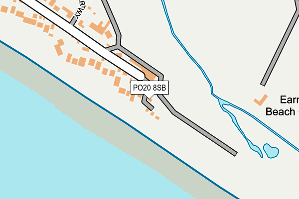
PO20 8SB is located in the The Witterings electoral ward, within the local authority district of Chichester and the English Parliamentary constituency of Chichester. The Sub Integrated Care Board (ICB) Location is NHS Sussex ICB - 70F and the police force is Sussex. This postcode has been in use since August 1993.


GetTheData
Source: OS OpenMap – Local (Ordnance Survey)
Source: OS VectorMap District (Ordnance Survey)
Licence: Open Government Licence (requires attribution)
| Easting | 481456 |
| Northing | 95786 |
| Latitude | 50.755955 |
| Longitude | -0.846568 |
GetTheData
Source: Open Postcode Geo
Licence: Open Government Licence
| Country | England |
| Postcode District | PO20 |
➜ See where PO20 is on a map ➜ Where is East Wittering? | |
GetTheData
Source: Land Registry Price Paid Data
Licence: Open Government Licence
Elevation or altitude of PO20 8SB as distance above sea level:
| Metres | Feet | |
|---|---|---|
| Elevation | 10m | 33ft |
Elevation is measured from the approximate centre of the postcode, to the nearest point on an OS contour line from OS Terrain 50, which has contour spacing of ten vertical metres.
➜ How high above sea level am I? Find the elevation of your current position using your device's GPS.
GetTheData
Source: Open Postcode Elevation
Licence: Open Government Licence
| Ward | The Witterings |
| Constituency | Chichester |
GetTheData
Source: ONS Postcode Database
Licence: Open Government Licence
| Woodborough Close (Shalbourne Crescent) | Bracklesham Bay | 643m |
| Woodborough Close (Shalbourne Crescent) | Bracklesham Bay | 651m |
| Church (Clappers Lane) | Earnley | 1,133m |
| Church (Clappers Lane) | Earnley | 1,138m |
| Lively Lady (Bracklesham Lane) | Bracklesham Bay | 1,227m |
GetTheData
Source: NaPTAN
Licence: Open Government Licence
GetTheData
Source: ONS Postcode Database
Licence: Open Government Licence


➜ Get more ratings from the Food Standards Agency
GetTheData
Source: Food Standards Agency
Licence: FSA terms & conditions
| Last Collection | |||
|---|---|---|---|
| Location | Mon-Fri | Sat | Distance |
| Bracklesham Bay C C | 16:30 | 08:00 | 94m |
| Sussex Beach Holiday Village | 16:15 | 09:00 | 528m |
| Earnley Church | 16:15 | 08:00 | 1,133m |
GetTheData
Source: Dracos
Licence: Creative Commons Attribution-ShareAlike
| Risk of PO20 8SB flooding from rivers and sea | High |
| ➜ PO20 8SB flood map | |
GetTheData
Source: Open Flood Risk by Postcode
Licence: Open Government Licence
The below table lists the International Territorial Level (ITL) codes (formerly Nomenclature of Territorial Units for Statistics (NUTS) codes) and Local Administrative Units (LAU) codes for PO20 8SB:
| ITL 1 Code | Name |
|---|---|
| TLJ | South East (England) |
| ITL 2 Code | Name |
| TLJ2 | Surrey, East and West Sussex |
| ITL 3 Code | Name |
| TLJ27 | West Sussex (South West) |
| LAU 1 Code | Name |
| E07000225 | Chichester |
GetTheData
Source: ONS Postcode Directory
Licence: Open Government Licence
The below table lists the Census Output Area (OA), Lower Layer Super Output Area (LSOA), and Middle Layer Super Output Area (MSOA) for PO20 8SB:
| Code | Name | |
|---|---|---|
| OA | E00160638 | |
| LSOA | E01031499 | Chichester 013A |
| MSOA | E02006573 | Chichester 013 |
GetTheData
Source: ONS Postcode Directory
Licence: Open Government Licence
| PO20 8QU | East Bracklesham Drive | 184m |
| PO20 8JR | Silver Way | 224m |
| PO20 8FD | Canute Close | 269m |
| PO20 8RH | Walmsleys Way | 306m |
| PO20 8JW | East Bracklesham Drive | 327m |
| PO20 8FH | Hayward Place | 339m |
| PO20 8FF | Tide Way | 374m |
| PO20 8FE | Tide Way | 397m |
| PO20 8FB | Chandlers Lea | 408m |
| PO20 8AQ | Sussex Grove | 489m |
GetTheData
Source: Open Postcode Geo; Land Registry Price Paid Data
Licence: Open Government Licence