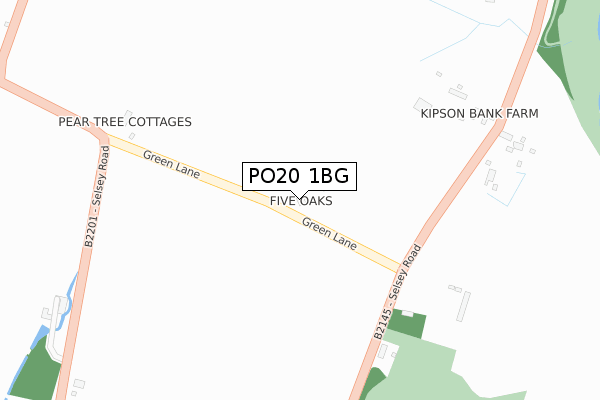
PO20 1BG is located in the North Mundham & Tangmere electoral ward, within the local authority district of Chichester and the English Parliamentary constituency of Chichester. The Sub Integrated Care Board (ICB) Location is NHS Sussex ICB - 70F and the police force is Sussex. This postcode has been in use since September 2019.


GetTheData
Source: OS Open Zoomstack (Ordnance Survey)
Licence: Open Government Licence (requires attribution)
Attribution: Contains OS data © Crown copyright and database right 2025
Source: Open Postcode Geo
Licence: Open Government Licence (requires attribution)
Attribution: Contains OS data © Crown copyright and database right 2025; Contains Royal Mail data © Royal Mail copyright and database right 2025; Source: Office for National Statistics licensed under the Open Government Licence v.3.0
| Easting | 486577 |
| Northing | 102191 |
| Latitude | 50.812799 |
| Longitude | -0.772479 |
GetTheData
Source: Open Postcode Geo
Licence: Open Government Licence
| Country | England |
| Postcode District | PO20 |
➜ See where PO20 is on a map ➜ Where is Hunston? | |
GetTheData
Source: Land Registry Price Paid Data
Licence: Open Government Licence
| Ward | North Mundham & Tangmere |
| Constituency | Chichester |
GetTheData
Source: ONS Postcode Database
Licence: Open Government Licence
2, CHERRY TREE CLOSE, HUNSTON, CHICHESTER, PO20 1BG 2022 26 MAY £695,000 |
GetTheData
Source: HM Land Registry Price Paid Data
Licence: Contains HM Land Registry data © Crown copyright and database right 2025. This data is licensed under the Open Government Licence v3.0.
| Spotted Cow Ph (Heath Close) | Hunston | 237m |
| Southover Way (Heath Close) | Hunston | 303m |
| Mundham Corner (B2145) | North Mundham | 549m |
| Mundham Corner (B2145) | North Mundham | 551m |
| Westlands Road (Heat Close) | Hunston | 565m |
| Chichester Station | 2.2km |
| Fishbourne Station | 4.2km |
GetTheData
Source: NaPTAN
Licence: Open Government Licence
GetTheData
Source: ONS Postcode Database
Licence: Open Government Licence


➜ Get more ratings from the Food Standards Agency
GetTheData
Source: Food Standards Agency
Licence: FSA terms & conditions
| Last Collection | |||
|---|---|---|---|
| Location | Mon-Fri | Sat | Distance |
| Hunston Post Office | 17:15 | 11:00 | 278m |
| Pelleys Lane Donnington | 16:00 | 07:15 | 1,236m |
| Birdham Road | 17:20 | 12:45 | 1,655m |
GetTheData
Source: Dracos
Licence: Creative Commons Attribution-ShareAlike
The below table lists the International Territorial Level (ITL) codes (formerly Nomenclature of Territorial Units for Statistics (NUTS) codes) and Local Administrative Units (LAU) codes for PO20 1BG:
| ITL 1 Code | Name |
|---|---|
| TLJ | South East (England) |
| ITL 2 Code | Name |
| TLJ2 | Surrey, East and West Sussex |
| ITL 3 Code | Name |
| TLJ27 | West Sussex (South West) |
| LAU 1 Code | Name |
| E07000225 | Chichester |
GetTheData
Source: ONS Postcode Directory
Licence: Open Government Licence
The below table lists the Census Output Area (OA), Lower Layer Super Output Area (LSOA), and Middle Layer Super Output Area (MSOA) for PO20 1BG:
| Code | Name | |
|---|---|---|
| OA | E00160801 | |
| LSOA | E01031530 | Chichester 012D |
| MSOA | E02006572 | Chichester 012 |
GetTheData
Source: ONS Postcode Directory
Licence: Open Government Licence
| PO20 1NQ | Foxbridge Drive | 101m |
| PO20 1NR | 133m | |
| PO20 1AH | Wilfs Copse | 152m |
| PO20 1NZ | Acacia Villas | 159m |
| PO20 1NY | Southover Way | 212m |
| PO20 1NS | Mayfield Place | 219m |
| PO20 1NT | Fairthorn Cottages | 226m |
| PO20 1NU | Nansen Cottages | 237m |
| PO20 1NX | New Cottages | 257m |
| PO20 1PB | Meadow Close | 299m |
GetTheData
Source: Open Postcode Geo; Land Registry Price Paid Data
Licence: Open Government Licence