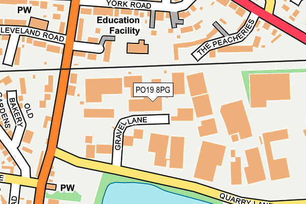
PO19 8PG is located in the Chichester South electoral ward, within the local authority district of Chichester and the English Parliamentary constituency of Chichester. The Sub Integrated Care Board (ICB) Location is NHS Sussex ICB - 70F and the police force is Sussex. This postcode has been in use since June 2002.


GetTheData
Source: OS OpenMap – Local (Ordnance Survey)
Source: OS VectorMap District (Ordnance Survey)
Licence: Open Government Licence (requires attribution)
| Easting | 487180 |
| Northing | 104274 |
| Latitude | 50.831446 |
| Longitude | -0.763447 |
GetTheData
Source: Open Postcode Geo
Licence: Open Government Licence
| Country | England |
| Postcode District | PO19 |
➜ See where PO19 is on a map ➜ Where is Chichester? | |
GetTheData
Source: Land Registry Price Paid Data
Licence: Open Government Licence
Elevation or altitude of PO19 8PG as distance above sea level:
| Metres | Feet | |
|---|---|---|
| Elevation | 10m | 33ft |
Elevation is measured from the approximate centre of the postcode, to the nearest point on an OS contour line from OS Terrain 50, which has contour spacing of ten vertical metres.
➜ How high above sea level am I? Find the elevation of your current position using your device's GPS.
GetTheData
Source: Open Postcode Elevation
Licence: Open Government Licence
| Ward | Chichester South |
| Constituency | Chichester |
GetTheData
Source: ONS Postcode Database
Licence: Open Government Licence
| Quarry Lane (Whyke Road) | Chichester | 181m |
| Quarry Lane (Whyke Road) | Chichester | 203m |
| Cambrai Avenue (Whyke Road) | Chichester | 260m |
| York Road (Bognor Road) | Chichester | 264m |
| The Peacheries (Bognor Road) | Chichester | 290m |
| Chichester Station | 1.3km |
| Fishbourne Station | 3.7km |
GetTheData
Source: NaPTAN
Licence: Open Government Licence
GetTheData
Source: ONS Postcode Database
Licence: Open Government Licence


➜ Get more ratings from the Food Standards Agency
GetTheData
Source: Food Standards Agency
Licence: FSA terms & conditions
| Last Collection | |||
|---|---|---|---|
| Location | Mon-Fri | Sat | Distance |
| Bognor Road Whyke | 16:20 | 11:30 | 315m |
| Cambrai Avenue | 18:30 | 11:30 | 352m |
| Quarry Lane | 17:20 | 11:45 | 379m |
GetTheData
Source: Dracos
Licence: Creative Commons Attribution-ShareAlike
| Risk of PO19 8PG flooding from rivers and sea | Low |
| ➜ PO19 8PG flood map | |
GetTheData
Source: Open Flood Risk by Postcode
Licence: Open Government Licence
The below table lists the International Territorial Level (ITL) codes (formerly Nomenclature of Territorial Units for Statistics (NUTS) codes) and Local Administrative Units (LAU) codes for PO19 8PG:
| ITL 1 Code | Name |
|---|---|
| TLJ | South East (England) |
| ITL 2 Code | Name |
| TLJ2 | Surrey, East and West Sussex |
| ITL 3 Code | Name |
| TLJ27 | West Sussex (South West) |
| LAU 1 Code | Name |
| E07000225 | Chichester |
GetTheData
Source: ONS Postcode Directory
Licence: Open Government Licence
The below table lists the Census Output Area (OA), Lower Layer Super Output Area (LSOA), and Middle Layer Super Output Area (MSOA) for PO19 8PG:
| Code | Name | |
|---|---|---|
| OA | E00160599 | |
| LSOA | E01031489 | Chichester 012A |
| MSOA | E02006572 | Chichester 012 |
GetTheData
Source: ONS Postcode Directory
Licence: Open Government Licence
| PO19 8PQ | Gravel Lane | 36m |
| PO19 7BL | Parham Close | 159m |
| PO19 7TP | The Peacheries | 164m |
| PO19 7UJ | Rumbolds Close | 166m |
| PO19 8HP | Whyke Road | 168m |
| PO19 7TL | York Road | 173m |
| PO19 7AW | Whyke Road | 195m |
| PO19 8HT | Whyke Road | 211m |
| PO19 7TJ | York Road | 223m |
| PO19 7AD | Cleveland Road | 241m |
GetTheData
Source: Open Postcode Geo; Land Registry Price Paid Data
Licence: Open Government Licence