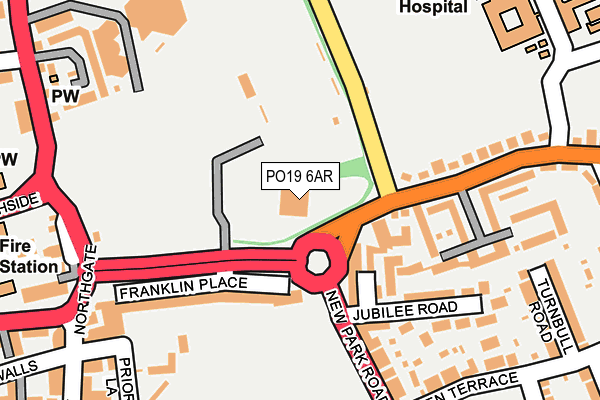
PO19 6AR is located in the Chichester North electoral ward, within the local authority district of Chichester and the English Parliamentary constituency of Chichester. The Sub Integrated Care Board (ICB) Location is NHS Sussex ICB - 70F and the police force is Sussex. This postcode has been in use since June 2002.


GetTheData
Source: OS OpenMap – Local (Ordnance Survey)
Source: OS VectorMap District (Ordnance Survey)
Licence: Open Government Licence (requires attribution)
| Easting | 486334 |
| Northing | 105355 |
| Latitude | 50.841282 |
| Longitude | -0.775183 |
GetTheData
Source: Open Postcode Geo
Licence: Open Government Licence
| Country | England |
| Postcode District | PO19 |
➜ See where PO19 is on a map ➜ Where is Chichester? | |
GetTheData
Source: Land Registry Price Paid Data
Licence: Open Government Licence
Elevation or altitude of PO19 6AR as distance above sea level:
| Metres | Feet | |
|---|---|---|
| Elevation | 20m | 66ft |
Elevation is measured from the approximate centre of the postcode, to the nearest point on an OS contour line from OS Terrain 50, which has contour spacing of ten vertical metres.
➜ How high above sea level am I? Find the elevation of your current position using your device's GPS.
GetTheData
Source: Open Postcode Elevation
Licence: Open Government Licence
| Ward | Chichester North |
| Constituency | Chichester |
GetTheData
Source: ONS Postcode Database
Licence: Open Government Licence
| Franklin Place (Oaklands Way) | Chichester | 144m |
| Franklin Place (Oaklands Way) | Chichester | 163m |
| St Richards Hospital Entrance (Spitalfield Lane) | Chichester | 194m |
| St Richards Hospital Entrance (Spitalfield Lane) | Chichester | 213m |
| The Bell Ph (Broyle Road) | Chichester | 262m |
| Chichester Station | 1.1km |
| Fishbourne Station | 2.8km |
GetTheData
Source: NaPTAN
Licence: Open Government Licence
GetTheData
Source: ONS Postcode Database
Licence: Open Government Licence


➜ Get more ratings from the Food Standards Agency
GetTheData
Source: Food Standards Agency
Licence: FSA terms & conditions
| Last Collection | |||
|---|---|---|---|
| Location | Mon-Fri | Sat | Distance |
| Northgate | 18:30 | 12:30 | 248m |
| Northgate | 18:30 | 12:30 | 248m |
| Litten Terrace | 16:00 | 12:30 | 376m |
GetTheData
Source: Dracos
Licence: Creative Commons Attribution-ShareAlike
The below table lists the International Territorial Level (ITL) codes (formerly Nomenclature of Territorial Units for Statistics (NUTS) codes) and Local Administrative Units (LAU) codes for PO19 6AR:
| ITL 1 Code | Name |
|---|---|
| TLJ | South East (England) |
| ITL 2 Code | Name |
| TLJ2 | Surrey, East and West Sussex |
| ITL 3 Code | Name |
| TLJ27 | West Sussex (South West) |
| LAU 1 Code | Name |
| E07000225 | Chichester |
GetTheData
Source: ONS Postcode Directory
Licence: Open Government Licence
The below table lists the Census Output Area (OA), Lower Layer Super Output Area (LSOA), and Middle Layer Super Output Area (MSOA) for PO19 6AR:
| Code | Name | |
|---|---|---|
| OA | E00160563 | |
| LSOA | E01031486 | Chichester 008C |
| MSOA | E02006568 | Chichester 008 |
GetTheData
Source: ONS Postcode Directory
Licence: Open Government Licence
| PO19 7XT | Jubilee Terrace | 89m |
| PO19 6FL | Bishopsgate Walk | 120m |
| PO19 1BL | Franklin Place | 127m |
| PO19 6FQ | Bishopsgate Walk | 141m |
| PO19 7XB | Jubilee Road | 172m |
| PO19 6SB | Spitalfield Lane | 174m |
| PO19 7XH | New Park Road | 184m |
| PO19 6FJ | Bishopsgate Walk | 208m |
| PO19 6FG | Bishopsgate Walk | 232m |
| PO19 1NL | Priory Lane | 239m |
GetTheData
Source: Open Postcode Geo; Land Registry Price Paid Data
Licence: Open Government Licence