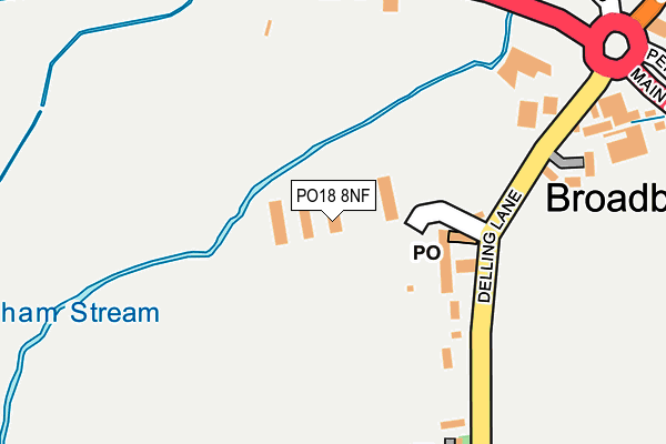
PO18 8NF is located in the Harbour Villages electoral ward, within the local authority district of Chichester and the English Parliamentary constituency of Chichester. The Sub Integrated Care Board (ICB) Location is NHS Sussex ICB - 70F and the police force is Sussex. This postcode has been in use since December 1998.


GetTheData
Source: OS OpenMap – Local (Ordnance Survey)
Source: OS VectorMap District (Ordnance Survey)
Licence: Open Government Licence (requires attribution)
| Easting | 480929 |
| Northing | 105114 |
| Latitude | 50.839895 |
| Longitude | -0.851985 |
GetTheData
Source: Open Postcode Geo
Licence: Open Government Licence
| Country | England |
| Postcode District | PO18 |
➜ See where PO18 is on a map ➜ Where is Broadbridge? | |
GetTheData
Source: Land Registry Price Paid Data
Licence: Open Government Licence
Elevation or altitude of PO18 8NF as distance above sea level:
| Metres | Feet | |
|---|---|---|
| Elevation | 10m | 33ft |
Elevation is measured from the approximate centre of the postcode, to the nearest point on an OS contour line from OS Terrain 50, which has contour spacing of ten vertical metres.
➜ How high above sea level am I? Find the elevation of your current position using your device's GPS.
GetTheData
Source: Open Postcode Elevation
Licence: Open Government Licence
| Ward | Harbour Villages |
| Constituency | Chichester |
GetTheData
Source: ONS Postcode Database
Licence: Open Government Licence
| Broadbridge Cricket Ground (Delling Lane) | Broadbridge | 98m |
| Broadbridge Cricket Ground (Delling Lane) | Broadbridge | 112m |
| Berrymead Cottages (A259) | Broadbridge | 214m |
| Berrymead Cottages (A259) | Broadbridge | 254m |
| The White Swan (A259) | Broadbridge | 259m |
| Bosham Station | 0.5km |
| Nutbourne Station | 2.3km |
| Fishbourne Station | 2.6km |
GetTheData
Source: NaPTAN
Licence: Open Government Licence
| Median download speed | 80.0Mbps |
| Average download speed | 61.5Mbps |
| Maximum download speed | 80.00Mbps |
| Median upload speed | 20.0Mbps |
| Average upload speed | 13.7Mbps |
| Maximum upload speed | 20.00Mbps |
GetTheData
Source: Ofcom
Licence: Ofcom Terms of Use (requires attribution)
GetTheData
Source: ONS Postcode Database
Licence: Open Government Licence


➜ Get more ratings from the Food Standards Agency
GetTheData
Source: Food Standards Agency
Licence: FSA terms & conditions
| Last Collection | |||
|---|---|---|---|
| Location | Mon-Fri | Sat | Distance |
| Bosham Post Office | 17:15 | 10:30 | 79m |
| Chequer Lane | 17:15 | 07:30 | 1,139m |
| Gosportside | 16:45 | 08:00 | 1,277m |
GetTheData
Source: Dracos
Licence: Creative Commons Attribution-ShareAlike
The below table lists the International Territorial Level (ITL) codes (formerly Nomenclature of Territorial Units for Statistics (NUTS) codes) and Local Administrative Units (LAU) codes for PO18 8NF:
| ITL 1 Code | Name |
|---|---|
| TLJ | South East (England) |
| ITL 2 Code | Name |
| TLJ2 | Surrey, East and West Sussex |
| ITL 3 Code | Name |
| TLJ27 | West Sussex (South West) |
| LAU 1 Code | Name |
| E07000225 | Chichester |
GetTheData
Source: ONS Postcode Directory
Licence: Open Government Licence
The below table lists the Census Output Area (OA), Lower Layer Super Output Area (LSOA), and Middle Layer Super Output Area (MSOA) for PO18 8NF:
| Code | Name | |
|---|---|---|
| OA | E00160514 | |
| LSOA | E01031476 | Chichester 009B |
| MSOA | E02006569 | Chichester 009 |
GetTheData
Source: ONS Postcode Directory
Licence: Open Government Licence
| PO18 8NN | Delling Lane | 79m |
| PO18 8PQ | Main Road | 194m |
| PO18 8PG | Old Bridge Road | 264m |
| PO18 8NS | Stanbury Close | 309m |
| PO18 8BY | Hamilton Gardens | 310m |
| PO18 8LG | Penwarden Way | 320m |
| PO18 8PX | Broadbridge Mill | 335m |
| PO18 8AF | Broadbridge Mill | 368m |
| PO18 8NG | Station Road | 373m |
| PO18 8PH | Main Road | 381m |
GetTheData
Source: Open Postcode Geo; Land Registry Price Paid Data
Licence: Open Government Licence