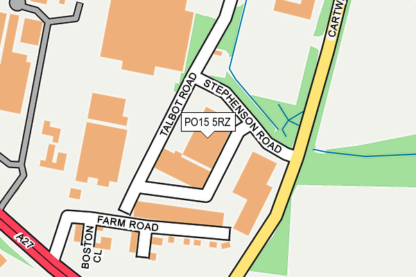
PO15 5RZ is located in the Titchfield electoral ward, within the local authority district of Fareham and the English Parliamentary constituency of Fareham. The Sub Integrated Care Board (ICB) Location is NHS Hampshire and Isle of Wight ICB - D9Y0V and the police force is Hampshire. This postcode has been in use since December 2000.


GetTheData
Source: OS OpenMap – Local (Ordnance Survey)
Source: OS VectorMap District (Ordnance Survey)
Licence: Open Government Licence (requires attribution)
| Easting | 453444 |
| Northing | 106722 |
| Latitude | 50.857539 |
| Longitude | -1.242057 |
GetTheData
Source: Open Postcode Geo
Licence: Open Government Licence
| Country | England |
| Postcode District | PO15 |
➜ See where PO15 is on a map ➜ Where is Titchfield Park? | |
GetTheData
Source: Land Registry Price Paid Data
Licence: Open Government Licence
Elevation or altitude of PO15 5RZ as distance above sea level:
| Metres | Feet | |
|---|---|---|
| Elevation | 30m | 98ft |
Elevation is measured from the approximate centre of the postcode, to the nearest point on an OS contour line from OS Terrain 50, which has contour spacing of ten vertical metres.
➜ How high above sea level am I? Find the elevation of your current position using your device's GPS.
GetTheData
Source: Open Postcode Elevation
Licence: Open Government Licence
| Ward | Titchfield |
| Constituency | Fareham |
GetTheData
Source: ONS Postcode Database
Licence: Open Government Licence
| Stephenson Road (Cartwright Drive) | Titchfield Park | 48m |
| Stephenson Road (Cartwright Drive) | Titchfield Park | 143m |
| Warsash Road | Titchfield Common | 360m |
| Warsash Road | Titchfield Common | 361m |
| Segensworth Road (Cartwright Drive) | Titchfield Park | 519m |
| Swanwick Station | 2.6km |
| Fareham Station | 3.6km |
| Bursledon Station | 5.3km |
GetTheData
Source: NaPTAN
Licence: Open Government Licence
GetTheData
Source: ONS Postcode Database
Licence: Open Government Licence


➜ Get more ratings from the Food Standards Agency
GetTheData
Source: Food Standards Agency
Licence: FSA terms & conditions
| Last Collection | |||
|---|---|---|---|
| Location | Mon-Fri | Sat | Distance |
| Priory/Southampton Hill | 17:00 | 09:15 | 369m |
| Prelate Way | 17:00 | 09:00 | 839m |
| Segensworth Road | 16:00 | 08:15 | 896m |
GetTheData
Source: Dracos
Licence: Creative Commons Attribution-ShareAlike
The below table lists the International Territorial Level (ITL) codes (formerly Nomenclature of Territorial Units for Statistics (NUTS) codes) and Local Administrative Units (LAU) codes for PO15 5RZ:
| ITL 1 Code | Name |
|---|---|
| TLJ | South East (England) |
| ITL 2 Code | Name |
| TLJ3 | Hampshire and Isle of Wight |
| ITL 3 Code | Name |
| TLJ35 | South Hampshire |
| LAU 1 Code | Name |
| E07000087 | Fareham |
GetTheData
Source: ONS Postcode Directory
Licence: Open Government Licence
The below table lists the Census Output Area (OA), Lower Layer Super Output Area (LSOA), and Middle Layer Super Output Area (MSOA) for PO15 5RZ:
| Code | Name | |
|---|---|---|
| OA | E00115784 | |
| LSOA | E01022780 | Fareham 002D |
| MSOA | E02004728 | Fareham 002 |
GetTheData
Source: ONS Postcode Directory
Licence: Open Government Licence
| PO15 5RU | Stephenson Road | 72m |
| PO15 5RJ | Cartwright Drive | 180m |
| PO15 5EF | Southway | 403m |
| PO15 5EN | Eastway | 415m |
| PO15 5TF | Valerian Avenue | 452m |
| PO15 5TQ | Purslane Gardens | 455m |
| PO14 4AY | Southampton Road | 470m |
| PO14 4AZ | Southampton Road | 484m |
| PO15 5TG | Bellflower Way | 487m |
| PO14 4BG | St Margarets Lane | 514m |
GetTheData
Source: Open Postcode Geo; Land Registry Price Paid Data
Licence: Open Government Licence