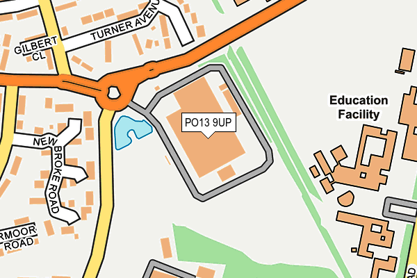
PO13 9UP is located in the Brockhurst & Privett electoral ward, within the local authority district of Gosport and the English Parliamentary constituency of Gosport. The Sub Integrated Care Board (ICB) Location is NHS Hampshire and Isle of Wight ICB - D9Y0V and the police force is Hampshire. This postcode has been in use since March 2008.


GetTheData
Source: OS OpenMap – Local (Ordnance Survey)
Source: OS VectorMap District (Ordnance Survey)
Licence: Open Government Licence (requires attribution)
| Easting | 459231 |
| Northing | 101582 |
| Latitude | 50.810770 |
| Longitude | -1.160689 |
GetTheData
Source: Open Postcode Geo
Licence: Open Government Licence
| Country | England |
| Postcode District | PO13 |
➜ See where PO13 is on a map ➜ Where is Gosport? | |
GetTheData
Source: Land Registry Price Paid Data
Licence: Open Government Licence
Elevation or altitude of PO13 9UP as distance above sea level:
| Metres | Feet | |
|---|---|---|
| Elevation | 10m | 33ft |
Elevation is measured from the approximate centre of the postcode, to the nearest point on an OS contour line from OS Terrain 50, which has contour spacing of ten vertical metres.
➜ How high above sea level am I? Find the elevation of your current position using your device's GPS.
GetTheData
Source: Open Postcode Elevation
Licence: Open Government Licence
| Ward | Brockhurst & Privett |
| Constituency | Gosport |
GetTheData
Source: ONS Postcode Database
Licence: Open Government Licence
| Tichborne Way (Rowner Road) | Rowner | 140m |
| Rowner Road (Grange Road) | Rowner | 144m |
| Brune Medical Centre (B3334 Rowner Road) | Fort Brockhurst | 244m |
| Tichborne Way (Rowner Road) | Rowner | 268m |
| Brune Medical Centre (B3334 Rowner Road) | Fort Brockhurst | 276m |
| Portsmouth Harbour Station | 4km |
| Portchester Station | 4.9km |
| Portsmouth & Southsea Station | 5.1km |
GetTheData
Source: NaPTAN
Licence: Open Government Licence
GetTheData
Source: ONS Postcode Database
Licence: Open Government Licence


➜ Get more ratings from the Food Standards Agency
GetTheData
Source: Food Standards Agency
Licence: FSA terms & conditions
| Last Collection | |||
|---|---|---|---|
| Location | Mon-Fri | Sat | Distance |
| Carless Close | 17:30 | 11:45 | 383m |
| Station Road | 17:30 | 11:15 | 513m |
| Withes Road | 16:45 | 11:30 | 542m |
GetTheData
Source: Dracos
Licence: Creative Commons Attribution-ShareAlike
The below table lists the International Territorial Level (ITL) codes (formerly Nomenclature of Territorial Units for Statistics (NUTS) codes) and Local Administrative Units (LAU) codes for PO13 9UP:
| ITL 1 Code | Name |
|---|---|
| TLJ | South East (England) |
| ITL 2 Code | Name |
| TLJ3 | Hampshire and Isle of Wight |
| ITL 3 Code | Name |
| TLJ35 | South Hampshire |
| LAU 1 Code | Name |
| E07000088 | Gosport |
GetTheData
Source: ONS Postcode Directory
Licence: Open Government Licence
The below table lists the Census Output Area (OA), Lower Layer Super Output Area (LSOA), and Middle Layer Super Output Area (MSOA) for PO13 9UP:
| Code | Name | |
|---|---|---|
| OA | E00115897 | |
| LSOA | E01032884 | Gosport 007F |
| MSOA | E02004747 | Gosport 007 |
GetTheData
Source: ONS Postcode Directory
Licence: Open Government Licence
| PO13 9UL | Madison Close | 177m |
| PO13 9UJ | Newbroke Road | 220m |
| PO13 9UA | Rowner Road | 237m |
| PO13 0BU | Turner Avenue | 238m |
| PO13 9RT | Newbroke Road | 242m |
| PO13 0BS | Turner Avenue | 260m |
| PO13 9RS | St Nicholas Avenue | 275m |
| PO13 0BP | Gilbert Close | 300m |
| PO13 9RL | St Nicholas Avenue | 329m |
| PO13 9RU | Aldermoor Road | 330m |
GetTheData
Source: Open Postcode Geo; Land Registry Price Paid Data
Licence: Open Government Licence