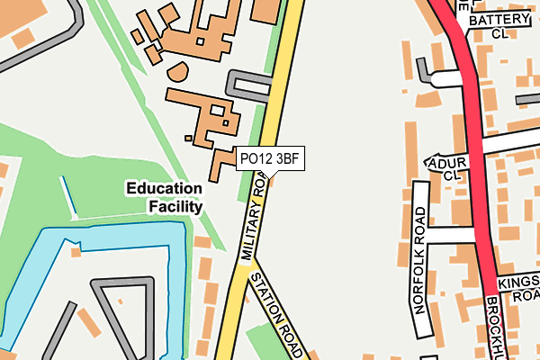
PO12 3BF is located in the Brockhurst & Privett electoral ward, within the local authority district of Gosport and the English Parliamentary constituency of Gosport. The Sub Integrated Care Board (ICB) Location is NHS Hampshire and Isle of Wight ICB - D9Y0V and the police force is Hampshire. This postcode has been in use since April 2017.


GetTheData
Source: OS OpenMap – Local (Ordnance Survey)
Source: OS VectorMap District (Ordnance Survey)
Licence: Open Government Licence (requires attribution)
| Easting | 459531 |
| Northing | 101376 |
| Latitude | 50.808877 |
| Longitude | -1.156453 |
GetTheData
Source: Open Postcode Geo
Licence: Open Government Licence
| Country | England |
| Postcode District | PO12 |
➜ See where PO12 is on a map ➜ Where is Gosport? | |
GetTheData
Source: Land Registry Price Paid Data
Licence: Open Government Licence
| Ward | Brockhurst & Privett |
| Constituency | Gosport |
GetTheData
Source: ONS Postcode Database
Licence: Open Government Licence
| Chantry Road (Brockhurst Road) | Brockhurst | 231m |
| Chantry Road (Brockhurst Road) | Brockhurst | 233m |
| Eastbourne Avenue (Brockhurst Road) | Brockhurst | 274m |
| Eastbourne Avenue (Brockhurst Road) | Brockhurst | 275m |
| Hastings Avenue (Eastbourne Avenue) | Elson | 359m |
| Portsmouth Harbour Station | 3.7km |
| Portsmouth & Southsea Station | 4.8km |
| Southsea Hoverport | 4.8km |
GetTheData
Source: NaPTAN
Licence: Open Government Licence
GetTheData
Source: ONS Postcode Database
Licence: Open Government Licence


➜ Get more ratings from the Food Standards Agency
GetTheData
Source: Food Standards Agency
Licence: FSA terms & conditions
| Last Collection | |||
|---|---|---|---|
| Location | Mon-Fri | Sat | Distance |
| Station Road | 17:30 | 11:15 | 186m |
| Brockenhurst Road | 17:15 | 12:00 | 244m |
| Redhouse Park Gardens | 16:15 | 11:15 | 344m |
GetTheData
Source: Dracos
Licence: Creative Commons Attribution-ShareAlike
The below table lists the International Territorial Level (ITL) codes (formerly Nomenclature of Territorial Units for Statistics (NUTS) codes) and Local Administrative Units (LAU) codes for PO12 3BF:
| ITL 1 Code | Name |
|---|---|
| TLJ | South East (England) |
| ITL 2 Code | Name |
| TLJ3 | Hampshire and Isle of Wight |
| ITL 3 Code | Name |
| TLJ35 | South Hampshire |
| LAU 1 Code | Name |
| E07000088 | Gosport |
GetTheData
Source: ONS Postcode Directory
Licence: Open Government Licence
The below table lists the Census Output Area (OA), Lower Layer Super Output Area (LSOA), and Middle Layer Super Output Area (MSOA) for PO12 3BF:
| Code | Name | |
|---|---|---|
| OA | E00115914 | |
| LSOA | E01032884 | Gosport 007F |
| MSOA | E02004747 | Gosport 007 |
GetTheData
Source: ONS Postcode Directory
Licence: Open Government Licence
| PO12 3EZ | Adur Close | 165m |
| PO12 3AW | Thetford Road | 183m |
| PO12 3AU | Captains Close | 201m |
| PO12 3AN | Norfolk Road | 204m |
| PO12 3BX | Military Road | 207m |
| PO12 3EY | Adur Close | 212m |
| PO12 3AY | Brockhurst Road | 219m |
| PO12 3AX | Brockhurst Road | 228m |
| PO12 3BH | Brockhurst Road | 248m |
| PO12 3BS | Greenlea Grove | 254m |
GetTheData
Source: Open Postcode Geo; Land Registry Price Paid Data
Licence: Open Government Licence