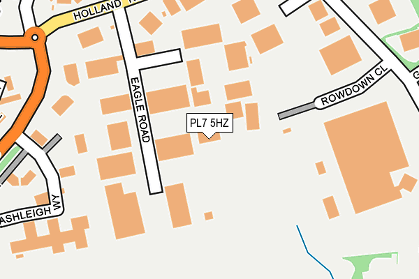
PL7 5HZ is located in the Newton & Yealmpton electoral ward, within the local authority district of South Hams and the English Parliamentary constituency of South West Devon. The Sub Integrated Care Board (ICB) Location is NHS Devon ICB - 15N and the police force is Devon & Cornwall. This postcode has been in use since September 2009.


GetTheData
Source: OS OpenMap – Local (Ordnance Survey)
Source: OS VectorMap District (Ordnance Survey)
Licence: Open Government Licence (requires attribution)
| Easting | 256529 |
| Northing | 55884 |
| Latitude | 50.385296 |
| Longitude | -4.019456 |
GetTheData
Source: Open Postcode Geo
Licence: Open Government Licence
| Country | England |
| Postcode District | PL7 |
➜ See where PL7 is on a map ➜ Where is Plymouth? | |
GetTheData
Source: Land Registry Price Paid Data
Licence: Open Government Licence
Elevation or altitude of PL7 5HZ as distance above sea level:
| Metres | Feet | |
|---|---|---|
| Elevation | 90m | 295ft |
Elevation is measured from the approximate centre of the postcode, to the nearest point on an OS contour line from OS Terrain 50, which has contour spacing of ten vertical metres.
➜ How high above sea level am I? Find the elevation of your current position using your device's GPS.
GetTheData
Source: Open Postcode Elevation
Licence: Open Government Licence
| Ward | Newton & Yealmpton |
| Constituency | South West Devon |
GetTheData
Source: ONS Postcode Database
Licence: Open Government Licence
| Holland Road South Side (Holland Road) | Langage | 257m |
| Holland Road North Side (Holland Road) | Langage | 264m |
| Eastern Wood Road Sub Station (Eastern Wood Way) | Langage | 265m |
| Eastern Wood Road Post Boxes (Eastern Wood Way) | Langage | 274m |
| Orange (Ashleigh Way) | Langage | 291m |
GetTheData
Source: NaPTAN
Licence: Open Government Licence
GetTheData
Source: ONS Postcode Database
Licence: Open Government Licence


➜ Get more ratings from the Food Standards Agency
GetTheData
Source: Food Standards Agency
Licence: FSA terms & conditions
| Last Collection | |||
|---|---|---|---|
| Location | Mon-Fri | Sat | Distance |
| Hemerdon | 16:30 | 07:10 | 1,589m |
| Westfield | 17:15 | 10:45 | 2,104m |
| Brixton Post Office | 17:00 | 10:45 | 3,904m |
GetTheData
Source: Dracos
Licence: Creative Commons Attribution-ShareAlike
The below table lists the International Territorial Level (ITL) codes (formerly Nomenclature of Territorial Units for Statistics (NUTS) codes) and Local Administrative Units (LAU) codes for PL7 5HZ:
| ITL 1 Code | Name |
|---|---|
| TLK | South West (England) |
| ITL 2 Code | Name |
| TLK4 | Devon |
| ITL 3 Code | Name |
| TLK43 | Devon CC |
| LAU 1 Code | Name |
| E07000044 | South Hams |
GetTheData
Source: ONS Postcode Directory
Licence: Open Government Licence
The below table lists the Census Output Area (OA), Lower Layer Super Output Area (LSOA), and Middle Layer Super Output Area (MSOA) for PL7 5HZ:
| Code | Name | |
|---|---|---|
| OA | E00102037 | |
| LSOA | E01020149 | South Hams 001D |
| MSOA | E02004189 | South Hams 001 |
GetTheData
Source: ONS Postcode Directory
Licence: Open Government Licence
| PL7 5JY | Eagle Road | 162m |
| PL7 5ET | Eastern Wood Road | 240m |
| PL7 5JX | Ashleigh Way | 290m |
| PL7 2ZH | Summerlands Gardens | 291m |
| PL7 2WU | Branson Court | 292m |
| PL7 2FL | Kidwelly Close | 306m |
| PL7 2ZJ | Summerlands Close | 332m |
| PL7 2ZE | Cypress Close | 389m |
| PL7 2ZF | Walnut Gardens | 403m |
| PL7 2WT | Campion Close | 415m |
GetTheData
Source: Open Postcode Geo; Land Registry Price Paid Data
Licence: Open Government Licence