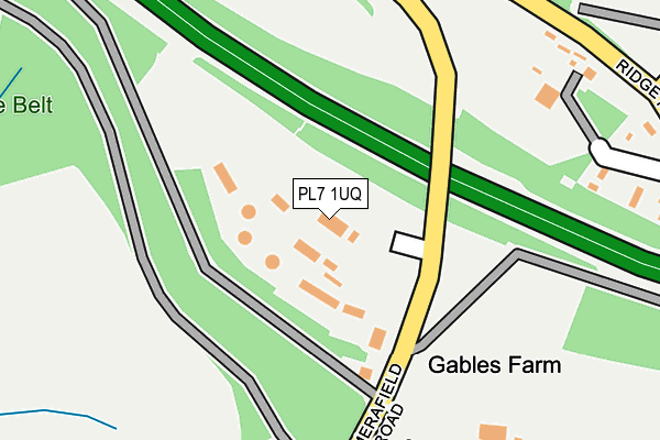
PL7 1UQ is located in the Plymstock Radford electoral ward, within the unitary authority of Plymouth and the English Parliamentary constituency of South West Devon. The Sub Integrated Care Board (ICB) Location is NHS Devon ICB - 15N and the police force is Devon & Cornwall. This postcode has been in use since June 1996.


GetTheData
Source: OS OpenMap – Local (Ordnance Survey)
Source: OS VectorMap District (Ordnance Survey)
Licence: Open Government Licence (requires attribution)
| Easting | 252957 |
| Northing | 55121 |
| Latitude | 50.377541 |
| Longitude | -4.069395 |
GetTheData
Source: Open Postcode Geo
Licence: Open Government Licence
| Country | England |
| Postcode District | PL7 |
➜ See where PL7 is on a map | |
GetTheData
Source: Land Registry Price Paid Data
Licence: Open Government Licence
Elevation or altitude of PL7 1UQ as distance above sea level:
| Metres | Feet | |
|---|---|---|
| Elevation | 50m | 164ft |
Elevation is measured from the approximate centre of the postcode, to the nearest point on an OS contour line from OS Terrain 50, which has contour spacing of ten vertical metres.
➜ How high above sea level am I? Find the elevation of your current position using your device's GPS.
GetTheData
Source: Open Postcode Elevation
Licence: Open Government Licence
| Ward | Plymstock Radford |
| Constituency | South West Devon |
GetTheData
Source: ONS Postcode Database
Licence: Open Government Licence
| Drake Memorial Park | Saltram | 249m |
| Drake Memorial Park | Saltram | 253m |
| Amados Drive | Underwood | 804m |
| Merafield Road | Underwood | 863m |
| Merafield Rise | Underwood | 866m |
GetTheData
Source: NaPTAN
Licence: Open Government Licence
GetTheData
Source: ONS Postcode Database
Licence: Open Government Licence


➜ Get more ratings from the Food Standards Agency
GetTheData
Source: Food Standards Agency
Licence: FSA terms & conditions
| Last Collection | |||
|---|---|---|---|
| Location | Mon-Fri | Sat | Distance |
| Reservoir Road | 17:00 | 12:45 | 1,809m |
| Greenacres | 17:00 | 13:00 | 1,831m |
| Stanborough Road | 17:00 | 12:45 | 1,856m |
GetTheData
Source: Dracos
Licence: Creative Commons Attribution-ShareAlike
The below table lists the International Territorial Level (ITL) codes (formerly Nomenclature of Territorial Units for Statistics (NUTS) codes) and Local Administrative Units (LAU) codes for PL7 1UQ:
| ITL 1 Code | Name |
|---|---|
| TLK | South West (England) |
| ITL 2 Code | Name |
| TLK4 | Devon |
| ITL 3 Code | Name |
| TLK41 | Plymouth |
| LAU 1 Code | Name |
| E06000026 | Plymouth |
GetTheData
Source: ONS Postcode Directory
Licence: Open Government Licence
The below table lists the Census Output Area (OA), Lower Layer Super Output Area (LSOA), and Middle Layer Super Output Area (MSOA) for PL7 1UQ:
| Code | Name | |
|---|---|---|
| OA | E00076449 | |
| LSOA | E01015135 | Plymouth 031A |
| MSOA | E02003152 | Plymouth 031 |
GetTheData
Source: ONS Postcode Directory
Licence: Open Government Licence
| PL7 1UG | Drunken Bridge Hill | 436m |
| PL9 8AT | Haye Road | 682m |
| PL7 1SW | Amados Close | 752m |
| PL7 1TT | Amados Drive | 767m |
| PL7 1TR | Merafield Drive | 795m |
| PL7 1TU | Amados Rise | 807m |
| PL7 1SN | Woodland Drive | 817m |
| PL7 1TS | Amados Drive | 819m |
| PL7 1UN | Grantham Close | 836m |
| PL7 1UL | Grantham Close | 843m |
GetTheData
Source: Open Postcode Geo; Land Registry Price Paid Data
Licence: Open Government Licence