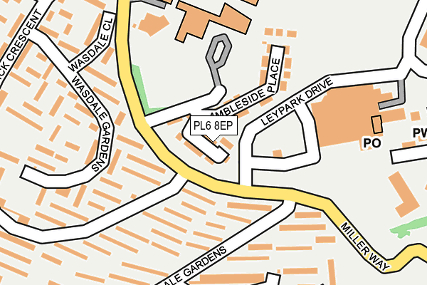
PL6 8EP is located in the Moor View electoral ward, within the unitary authority of Plymouth and the English Parliamentary constituency of Plymouth, Moor View. The Sub Integrated Care Board (ICB) Location is NHS Devon ICB - 15N and the police force is Devon & Cornwall. This postcode has been in use since April 2017.


GetTheData
Source: OS OpenMap – Local (Ordnance Survey)
Source: OS VectorMap District (Ordnance Survey)
Licence: Open Government Licence (requires attribution)
| Easting | 250890 |
| Northing | 58700 |
| Latitude | 50.409186 |
| Longitude | -4.099865 |
GetTheData
Source: Open Postcode Geo
Licence: Open Government Licence
| Country | England |
| Postcode District | PL6 |
➜ See where PL6 is on a map ➜ Where is Plymouth? | |
GetTheData
Source: Land Registry Price Paid Data
Licence: Open Government Licence
| Ward | Moor View |
| Constituency | Plymouth, Moor View |
GetTheData
Source: ONS Postcode Database
Licence: Open Government Licence
14, RAVENGLASS CLOSE, PLYMOUTH, PL6 8EP 2017 7 APR £255,000 |
GetTheData
Source: HM Land Registry Price Paid Data
Licence: Contains HM Land Registry data © Crown copyright and database right 2024. This data is licensed under the Open Government Licence v3.0.
| Leypark Drive (Miller Way) | Estover | 52m |
| Leypark Drive (Miller Way) | Estover | 67m |
| Asda | Estover | 148m |
| Keswick Crescent | Estover | 261m |
| Keswick Crescent | Estover | 278m |
| Plymouth Station | 4.7km |
GetTheData
Source: NaPTAN
Licence: Open Government Licence
| Percentage of properties with Next Generation Access | 100.0% |
| Percentage of properties with Superfast Broadband | 100.0% |
| Percentage of properties with Ultrafast Broadband | 0.0% |
| Percentage of properties with Full Fibre Broadband | 0.0% |
Superfast Broadband is between 30Mbps and 300Mbps
Ultrafast Broadband is > 300Mbps
| Median download speed | 40.0Mbps |
| Average download speed | 41.5Mbps |
| Maximum download speed | 63.79Mbps |
| Median upload speed | 10.0Mbps |
| Average upload speed | 11.8Mbps |
| Maximum upload speed | 20.00Mbps |
| Percentage of properties unable to receive 2Mbps | 0.0% |
| Percentage of properties unable to receive 5Mbps | 0.0% |
| Percentage of properties unable to receive 10Mbps | 0.0% |
| Percentage of properties unable to receive 30Mbps | 0.0% |
GetTheData
Source: Ofcom
Licence: Ofcom Terms of Use (requires attribution)
GetTheData
Source: ONS Postcode Database
Licence: Open Government Licence


➜ Get more ratings from the Food Standards Agency
GetTheData
Source: Food Standards Agency
Licence: FSA terms & conditions
| Last Collection | |||
|---|---|---|---|
| Location | Mon-Fri | Sat | Distance |
| Langdale Gardens | 17:00 | 12:00 | 660m |
| Erlstoke Close | 17:30 | 12:30 | 735m |
| Combley Drive | 17:15 | 12:30 | 972m |
GetTheData
Source: Dracos
Licence: Creative Commons Attribution-ShareAlike
The below table lists the International Territorial Level (ITL) codes (formerly Nomenclature of Territorial Units for Statistics (NUTS) codes) and Local Administrative Units (LAU) codes for PL6 8EP:
| ITL 1 Code | Name |
|---|---|
| TLK | South West (England) |
| ITL 2 Code | Name |
| TLK4 | Devon |
| ITL 3 Code | Name |
| TLK41 | Plymouth |
| LAU 1 Code | Name |
| E06000026 | Plymouth |
GetTheData
Source: ONS Postcode Directory
Licence: Open Government Licence
The below table lists the Census Output Area (OA), Lower Layer Super Output Area (LSOA), and Middle Layer Super Output Area (MSOA) for PL6 8EP:
| Code | Name | |
|---|---|---|
| OA | E00076256 | |
| LSOA | E01015094 | Plymouth 005E |
| MSOA | E02003126 | Plymouth 005 |
GetTheData
Source: ONS Postcode Directory
Licence: Open Government Licence
| PL6 8TN | Wasdale Gardens | 126m |
| PL6 8SL | Keswick Crescent | 169m |
| PL6 8SW | Langdale Gardens | 203m |
| PL6 8TW | Wasdale Gardens | 214m |
| PL6 8TL | Wasdale Close | 228m |
| PL6 8SP | Langdale Close | 235m |
| PL6 8SN | Langdale Gardens | 252m |
| PL6 8TS | Keswick Crescent | 276m |
| PL6 8TT | Keswick Crescent | 282m |
| PL6 8TP | Torver Close | 349m |
GetTheData
Source: Open Postcode Geo; Land Registry Price Paid Data
Licence: Open Government Licence