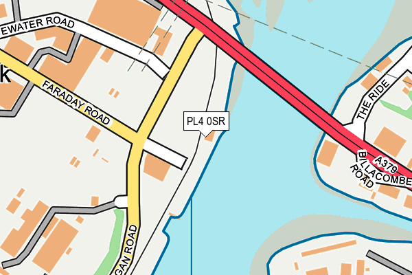
PL4 0SR is located in the Sutton and Mount Gould electoral ward, within the unitary authority of Plymouth and the English Parliamentary constituency of Plymouth, Sutton and Devonport. The Sub Integrated Care Board (ICB) Location is NHS Devon ICB - 15N and the police force is Devon & Cornwall. This postcode has been in use since January 1980.


GetTheData
Source: OS OpenMap – Local (Ordnance Survey)
Source: OS VectorMap District (Ordnance Survey)
Licence: Open Government Licence (requires attribution)
| Easting | 250022 |
| Northing | 54150 |
| Latitude | 50.368073 |
| Longitude | -4.110257 |
GetTheData
Source: Open Postcode Geo
Licence: Open Government Licence
| Country | England |
| Postcode District | PL4 |
➜ See where PL4 is on a map ➜ Where is Plymouth? | |
GetTheData
Source: Land Registry Price Paid Data
Licence: Open Government Licence
Elevation or altitude of PL4 0SR as distance above sea level:
| Metres | Feet | |
|---|---|---|
| Elevation | 10m | 33ft |
Elevation is measured from the approximate centre of the postcode, to the nearest point on an OS contour line from OS Terrain 50, which has contour spacing of ten vertical metres.
➜ How high above sea level am I? Find the elevation of your current position using your device's GPS.
GetTheData
Source: Open Postcode Elevation
Licence: Open Government Licence
| Ward | Sutton And Mount Gould |
| Constituency | Plymouth, Sutton And Devonport |
GetTheData
Source: ONS Postcode Database
Licence: Open Government Licence
| Morley Arms (Billacombe Road) | Pomphlett | 255m |
| Wakehams Quarry | Cattedown | 301m |
| Plymouth Gate (Laira Bridge Road) | Cattedown | 310m |
| Laira Bridge (Laira Bridge Road) | Cattedown | 334m |
| Sugar Mill | Pomphlett | 368m |
| Plymouth Station | 2.6km |
| Devonport Station | 4.5km |
| Dockyard (Plymouth) Station | 4.9km |
GetTheData
Source: NaPTAN
Licence: Open Government Licence
GetTheData
Source: ONS Postcode Database
Licence: Open Government Licence


➜ Get more ratings from the Food Standards Agency
GetTheData
Source: Food Standards Agency
Licence: FSA terms & conditions
| Last Collection | |||
|---|---|---|---|
| Location | Mon-Fri | Sat | Distance |
| Breakwater Road | 18:00 | 12:15 | 433m |
| Grenville Road | 18:45 | 13:15 | 535m |
| Plymouth Mail Centre | 19:30 | 17:30 | 542m |
GetTheData
Source: Dracos
Licence: Creative Commons Attribution-ShareAlike
The below table lists the International Territorial Level (ITL) codes (formerly Nomenclature of Territorial Units for Statistics (NUTS) codes) and Local Administrative Units (LAU) codes for PL4 0SR:
| ITL 1 Code | Name |
|---|---|
| TLK | South West (England) |
| ITL 2 Code | Name |
| TLK4 | Devon |
| ITL 3 Code | Name |
| TLK41 | Plymouth |
| LAU 1 Code | Name |
| E06000026 | Plymouth |
GetTheData
Source: ONS Postcode Directory
Licence: Open Government Licence
The below table lists the Census Output Area (OA), Lower Layer Super Output Area (LSOA), and Middle Layer Super Output Area (MSOA) for PL4 0SR:
| Code | Name | |
|---|---|---|
| OA | E00076688 | |
| LSOA | E01015182 | Plymouth 028E |
| MSOA | E02003149 | Plymouth 028 |
GetTheData
Source: ONS Postcode Directory
Licence: Open Government Licence
| PL9 7HP | Billacombe Road | 325m |
| PL4 0ST | Faraday Mill Business Park | 338m |
| PL4 9PA | Cavendish Road | 406m |
| PL4 9NZ | Hawarden Cotts | 423m |
| PL4 9LW | Laira Bridge Road | 431m |
| PL4 9NY | Cromartie Road | 438m |
| PL4 0SN | Maxwell Road | 464m |
| PL4 9PD | Radford Avenue | 471m |
| PL4 0PT | Oakfield Terrace Road | 473m |
| PL4 9NR | River View | 490m |
GetTheData
Source: Open Postcode Geo; Land Registry Price Paid Data
Licence: Open Government Licence