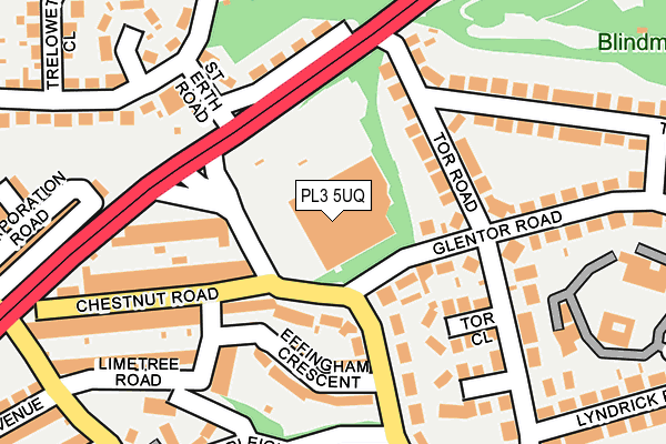
PL3 5UQ is located in the Peverell electoral ward, within the unitary authority of Plymouth and the English Parliamentary constituency of Plymouth, Sutton and Devonport. The Sub Integrated Care Board (ICB) Location is NHS Devon ICB - 15N and the police force is Devon & Cornwall. This postcode has been in use since August 1993.


GetTheData
Source: OS OpenMap – Local (Ordnance Survey)
Source: OS VectorMap District (Ordnance Survey)
Licence: Open Government Licence (requires attribution)
| Easting | 247983 |
| Northing | 57377 |
| Latitude | 50.396565 |
| Longitude | -4.140184 |
GetTheData
Source: Open Postcode Geo
Licence: Open Government Licence
| Country | England |
| Postcode District | PL3 |
➜ See where PL3 is on a map ➜ Where is Plymouth? | |
GetTheData
Source: Land Registry Price Paid Data
Licence: Open Government Licence
Elevation or altitude of PL3 5UQ as distance above sea level:
| Metres | Feet | |
|---|---|---|
| Elevation | 80m | 262ft |
Elevation is measured from the approximate centre of the postcode, to the nearest point on an OS contour line from OS Terrain 50, which has contour spacing of ten vertical metres.
➜ How high above sea level am I? Find the elevation of your current position using your device's GPS.
GetTheData
Source: Open Postcode Elevation
Licence: Open Government Licence
| Ward | Peverell |
| Constituency | Plymouth, Sutton And Devonport |
GetTheData
Source: ONS Postcode Database
Licence: Open Government Licence
| Tor Lane Superstore | Hartley | 68m |
| Torr Lane Superstore (Torr Lane) | Hartley | 84m |
| Outland Road Superstore | Hartley | 111m |
| Effingham Crescent | Hartley | 114m |
| Effingham Crescent (Torr Lane) | Hartley | 124m |
| Plymouth Station | 2.1km |
| Keyham Station | 2.9km |
| Devonport Station | 3km |
GetTheData
Source: NaPTAN
Licence: Open Government Licence
GetTheData
Source: ONS Postcode Database
Licence: Open Government Licence


➜ Get more ratings from the Food Standards Agency
GetTheData
Source: Food Standards Agency
Licence: FSA terms & conditions
| Last Collection | |||
|---|---|---|---|
| Location | Mon-Fri | Sat | Distance |
| Venn Grove | 17:30 | 12:30 | 231m |
| Burnham Park Road | 17:30 | 12:15 | 299m |
| Torr Crescent | 17:30 | 12:30 | 342m |
GetTheData
Source: Dracos
Licence: Creative Commons Attribution-ShareAlike
The below table lists the International Territorial Level (ITL) codes (formerly Nomenclature of Territorial Units for Statistics (NUTS) codes) and Local Administrative Units (LAU) codes for PL3 5UQ:
| ITL 1 Code | Name |
|---|---|
| TLK | South West (England) |
| ITL 2 Code | Name |
| TLK4 | Devon |
| ITL 3 Code | Name |
| TLK41 | Plymouth |
| LAU 1 Code | Name |
| E06000026 | Plymouth |
GetTheData
Source: ONS Postcode Directory
Licence: Open Government Licence
The below table lists the Census Output Area (OA), Lower Layer Super Output Area (LSOA), and Middle Layer Super Output Area (MSOA) for PL3 5UQ:
| Code | Name | |
|---|---|---|
| OA | E00076307 | |
| LSOA | E01015101 | Plymouth 016E |
| MSOA | E02003137 | Plymouth 016 |
GetTheData
Source: ONS Postcode Directory
Licence: Open Government Licence
| PL3 5TL | Torr Lane | 97m |
| PL3 5TR | Glentor Road | 97m |
| PL3 5UD | Chestnut Road | 104m |
| PL3 5UF | Torr Lane | 123m |
| PL3 5TN | Effingham Crescent | 129m |
| PL3 5TD | Tor Road | 133m |
| PL3 5TE | Tor Road | 135m |
| PL3 5TH | Tor Close | 138m |
| PL2 3SP | Outland Road | 157m |
| PL2 3SW | St Erth Road | 172m |
GetTheData
Source: Open Postcode Geo; Land Registry Price Paid Data
Licence: Open Government Licence