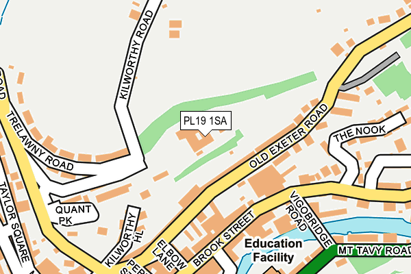
PL19 1SA is located in the Tavistock North electoral ward, within the local authority district of West Devon and the English Parliamentary constituency of Torridge and West Devon. The Sub Integrated Care Board (ICB) Location is NHS Devon ICB - 15N and the police force is Devon & Cornwall. This postcode has been in use since February 2005.


GetTheData
Source: OS OpenMap – Local (Ordnance Survey)
Source: OS VectorMap District (Ordnance Survey)
Licence: Open Government Licence (requires attribution)
| Easting | 248261 |
| Northing | 74729 |
| Latitude | 50.552564 |
| Longitude | -4.143346 |
GetTheData
Source: Open Postcode Geo
Licence: Open Government Licence
| Country | England |
| Postcode District | PL19 |
➜ See where PL19 is on a map ➜ Where is Tavistock? | |
GetTheData
Source: Land Registry Price Paid Data
Licence: Open Government Licence
Elevation or altitude of PL19 1SA as distance above sea level:
| Metres | Feet | |
|---|---|---|
| Elevation | 110m | 361ft |
Elevation is measured from the approximate centre of the postcode, to the nearest point on an OS contour line from OS Terrain 50, which has contour spacing of ten vertical metres.
➜ How high above sea level am I? Find the elevation of your current position using your device's GPS.
GetTheData
Source: Open Postcode Elevation
Licence: Open Government Licence
| Ward | Tavistock North |
| Constituency | Torridge And West Devon |
GetTheData
Source: ONS Postcode Database
Licence: Open Government Licence
| Lawsons (Parkwood Road) | Tavistock | 164m |
| Lawsons (Parkwood Road) | Tavistock | 171m |
| Lawsons (Brook Street) | Tavistock | 177m |
| St. Rumons School (Dolvin Road) | Tavistock | 249m |
| Bedford Square | Tavistock | 319m |
GetTheData
Source: NaPTAN
Licence: Open Government Licence
GetTheData
Source: ONS Postcode Database
Licence: Open Government Licence


➜ Get more ratings from the Food Standards Agency
GetTheData
Source: Food Standards Agency
Licence: FSA terms & conditions
| Last Collection | |||
|---|---|---|---|
| Location | Mon-Fri | Sat | Distance |
| Exeter Street | 12:00 | 12:00 | 82m |
| Brook Street | 16:45 | 12:00 | 144m |
| Trelawney Road | 12:00 | 12:00 | 166m |
GetTheData
Source: Dracos
Licence: Creative Commons Attribution-ShareAlike
The below table lists the International Territorial Level (ITL) codes (formerly Nomenclature of Territorial Units for Statistics (NUTS) codes) and Local Administrative Units (LAU) codes for PL19 1SA:
| ITL 1 Code | Name |
|---|---|
| TLK | South West (England) |
| ITL 2 Code | Name |
| TLK4 | Devon |
| ITL 3 Code | Name |
| TLK43 | Devon CC |
| LAU 1 Code | Name |
| E07000047 | West Devon |
GetTheData
Source: ONS Postcode Directory
Licence: Open Government Licence
The below table lists the Census Output Area (OA), Lower Layer Super Output Area (LSOA), and Middle Layer Super Output Area (MSOA) for PL19 1SA:
| Code | Name | |
|---|---|---|
| OA | E00103019 | |
| LSOA | E01020332 | West Devon 005A |
| MSOA | E02004233 | West Devon 005 |
GetTheData
Source: ONS Postcode Directory
Licence: Open Government Licence
| PL19 0JE | Old Exeter Road | 59m |
| PL19 0GZ | Brook Street | 106m |
| PL19 0JG | Town Mill Gardens | 114m |
| PL19 0HF | Paddons Row | 130m |
| PL19 0HD | Brook Street | 135m |
| PL19 0HE | Brook Street | 143m |
| PL19 0LD | Dancy Mews | 163m |
| PL19 0EY | Vigo Bridge Road | 172m |
| PL19 0HN | Laburnum | 189m |
| PL19 0HQ | Parkwood Road | 190m |
GetTheData
Source: Open Postcode Geo; Land Registry Price Paid Data
Licence: Open Government Licence