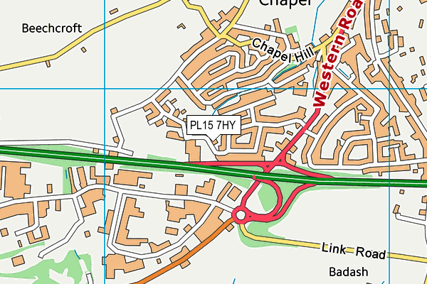
PL15 7HY is located in the Launceston South electoral ward, within the unitary authority of Cornwall and the English Parliamentary constituency of North Cornwall. The Sub Integrated Care Board (ICB) Location is NHS Cornwall and the Isles of Scilly ICB - 11N and the police force is Devon & Cornwall. This postcode has been in use since January 1980.


GetTheData
Source: OS OpenMap – Local (Ordnance Survey)
Source: OS VectorMap District (Ordnance Survey)
Licence: Open Government Licence (requires attribution)
| Easting | 232385 |
| Northing | 83811 |
| Latitude | 50.629840 |
| Longitude | -4.371329 |
GetTheData
Source: Open Postcode Geo
Licence: Open Government Licence
| Country | England |
| Postcode District | PL15 |
➜ See where PL15 is on a map ➜ Where is Launceston? | |
GetTheData
Source: Land Registry Price Paid Data
Licence: Open Government Licence
Elevation or altitude of PL15 7HY as distance above sea level:
| Metres | Feet | |
|---|---|---|
| Elevation | 140m | 459ft |
Elevation is measured from the approximate centre of the postcode, to the nearest point on an OS contour line from OS Terrain 50, which has contour spacing of ten vertical metres.
➜ How high above sea level am I? Find the elevation of your current position using your device's GPS.
GetTheData
Source: Open Postcode Elevation
Licence: Open Government Licence
| Ward | Launceston South |
| Constituency | North Cornwall |
GetTheData
Source: ONS Postcode Database
Licence: Open Government Licence
| Castle Meadows (St Johns Road) | Launceston | 148m |
| Castle Meadows (St Johns Road) | Launceston | 160m |
| Guinness Trust (George Fox Close) | Launceston | 220m |
| Guinness Trust (George Fox Close) | Launceston | 222m |
| Pennygillam (Western Road) | Launceston | 228m |
GetTheData
Source: NaPTAN
Licence: Open Government Licence
GetTheData
Source: ONS Postcode Database
Licence: Open Government Licence


➜ Get more ratings from the Food Standards Agency
GetTheData
Source: Food Standards Agency
Licence: FSA terms & conditions
| Last Collection | |||
|---|---|---|---|
| Location | Mon-Fri | Sat | Distance |
| Kennards House | 10:30 | 10:30 | 3,619m |
| Lanstephan | 17:15 | 10:15 | 3,768m |
GetTheData
Source: Dracos
Licence: Creative Commons Attribution-ShareAlike
The below table lists the International Territorial Level (ITL) codes (formerly Nomenclature of Territorial Units for Statistics (NUTS) codes) and Local Administrative Units (LAU) codes for PL15 7HY:
| ITL 1 Code | Name |
|---|---|
| TLK | South West (England) |
| ITL 2 Code | Name |
| TLK3 | Cornwall and Isles of Scilly |
| ITL 3 Code | Name |
| TLK30 | Cornwall and Isles of Scilly |
| LAU 1 Code | Name |
| E06000052 | Cornwall |
GetTheData
Source: ONS Postcode Directory
Licence: Open Government Licence
The below table lists the Census Output Area (OA), Lower Layer Super Output Area (LSOA), and Middle Layer Super Output Area (MSOA) for PL15 7HY:
| Code | Name | |
|---|---|---|
| OA | E00095676 | |
| LSOA | E01018946 | Cornwall 005A |
| MSOA | E02003935 | Cornwall 005 |
GetTheData
Source: ONS Postcode Directory
Licence: Open Government Licence
| PL15 7DE | St Johns Road | 95m |
| PL15 7DD | St Johns Road | 118m |
| PL15 7DB | St Johns Road | 134m |
| PL15 7DN | Moorland Road | 136m |
| PL15 7DZ | Castle Meadows | 151m |
| PL15 7DL | Meadowside | 194m |
| PL15 7DJ | Meadowside | 230m |
| PL15 7DW | Upper Chapel | 239m |
| PL15 7DA | St Johns Road | 244m |
| PL15 7DY | Highfield Park Road | 264m |
GetTheData
Source: Open Postcode Geo; Land Registry Price Paid Data
Licence: Open Government Licence