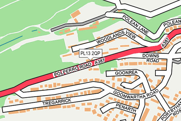
PL13 2QP is located in the Looe West, Pelynt, Lansallos & Lanteglos electoral ward, within the unitary authority of Cornwall and the English Parliamentary constituency of South East Cornwall. The Sub Integrated Care Board (ICB) Location is NHS Cornwall and the Isles of Scilly ICB - 11N and the police force is Devon & Cornwall. This postcode has been in use since January 1983.


GetTheData
Source: OS OpenMap – Local (Ordnance Survey)
Source: OS VectorMap District (Ordnance Survey)
Licence: Open Government Licence (requires attribution)
| Easting | 224772 |
| Northing | 53561 |
| Latitude | 50.355814 |
| Longitude | -4.464676 |
GetTheData
Source: Open Postcode Geo
Licence: Open Government Licence
| Country | England |
| Postcode District | PL13 |
➜ See where PL13 is on a map ➜ Where is Looe? | |
GetTheData
Source: Land Registry Price Paid Data
Licence: Open Government Licence
Elevation or altitude of PL13 2QP as distance above sea level:
| Metres | Feet | |
|---|---|---|
| Elevation | 60m | 197ft |
Elevation is measured from the approximate centre of the postcode, to the nearest point on an OS contour line from OS Terrain 50, which has contour spacing of ten vertical metres.
➜ How high above sea level am I? Find the elevation of your current position using your device's GPS.
GetTheData
Source: Open Postcode Elevation
Licence: Open Government Licence
| Ward | Looe West, Pelynt, Lansallos & Lanteglos |
| Constituency | South East Cornwall |
GetTheData
Source: ONS Postcode Database
Licence: Open Government Licence
| Downs Road (Polperro Road) | West Looe | 78m |
| Downs Road | West Looe | 80m |
| Tregarrick Court (Polperro Road) | West Looe | 258m |
| Junction Goonwartha Road (Polperro Road) | West Looe | 276m |
| Mill Pool Car Park | Looe | 391m |
| Looe Station | 0.7km |
| Sandplace Station | 3.4km |
GetTheData
Source: NaPTAN
Licence: Open Government Licence
GetTheData
Source: ONS Postcode Database
Licence: Open Government Licence


➜ Get more ratings from the Food Standards Agency
GetTheData
Source: Food Standards Agency
Licence: FSA terms & conditions
| Last Collection | |||
|---|---|---|---|
| Location | Mon-Fri | Sat | Distance |
| Beech Terrace | 11:15 | 11:15 | 238m |
| North Road | 11:15 | 11:15 | 517m |
| Looe Post Office | 17:15 | 12:00 | 766m |
GetTheData
Source: Dracos
Licence: Creative Commons Attribution-ShareAlike
The below table lists the International Territorial Level (ITL) codes (formerly Nomenclature of Territorial Units for Statistics (NUTS) codes) and Local Administrative Units (LAU) codes for PL13 2QP:
| ITL 1 Code | Name |
|---|---|
| TLK | South West (England) |
| ITL 2 Code | Name |
| TLK3 | Cornwall and Isles of Scilly |
| ITL 3 Code | Name |
| TLK30 | Cornwall and Isles of Scilly |
| LAU 1 Code | Name |
| E06000052 | Cornwall |
GetTheData
Source: ONS Postcode Directory
Licence: Open Government Licence
The below table lists the Census Output Area (OA), Lower Layer Super Output Area (LSOA), and Middle Layer Super Output Area (MSOA) for PL13 2QP:
| Code | Name | |
|---|---|---|
| OA | E00094782 | |
| LSOA | E01018773 | Cornwall 037B |
| MSOA | E02003904 | Cornwall 037 |
GetTheData
Source: ONS Postcode Directory
Licence: Open Government Licence
| PL13 2SE | Lower Goonrea | 31m |
| PL13 2AW | Woodlands View | 61m |
| PL13 2AN | Woodlands View | 92m |
| PL13 2AL | 108m | |
| PL13 2PJ | Goonwartha Road | 123m |
| PL13 2PH | Goonrea | 129m |
| PL13 2AR | Downs Road | 159m |
| PL13 2QW | Penarth | 179m |
| PL13 2SD | Tregarrick | 191m |
| PL13 2SG | Goonwartha Close | 224m |
GetTheData
Source: Open Postcode Geo; Land Registry Price Paid Data
Licence: Open Government Licence