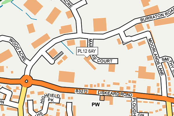
PL12 6AY lies on Burraton Road in Saltash. PL12 6AY is located in the Saltash Tamar electoral ward, within the unitary authority of Cornwall and the English Parliamentary constituency of South East Cornwall. The Sub Integrated Care Board (ICB) Location is NHS Cornwall and the Isles of Scilly ICB - 11N and the police force is Devon & Cornwall. This postcode has been in use since May 2008.


GetTheData
Source: OS OpenMap – Local (Ordnance Survey)
Source: OS VectorMap District (Ordnance Survey)
Licence: Open Government Licence (requires attribution)
| Easting | 241007 |
| Northing | 59566 |
| Latitude | 50.414376 |
| Longitude | -4.239214 |
GetTheData
Source: Open Postcode Geo
Licence: Open Government Licence
| Street | Burraton Road |
| Town/City | Saltash |
| Country | England |
| Postcode District | PL12 |
➜ See where PL12 is on a map ➜ Where is Saltash? | |
GetTheData
Source: Land Registry Price Paid Data
Licence: Open Government Licence
Elevation or altitude of PL12 6AY as distance above sea level:
| Metres | Feet | |
|---|---|---|
| Elevation | 60m | 197ft |
Elevation is measured from the approximate centre of the postcode, to the nearest point on an OS contour line from OS Terrain 50, which has contour spacing of ten vertical metres.
➜ How high above sea level am I? Find the elevation of your current position using your device's GPS.
GetTheData
Source: Open Postcode Elevation
Licence: Open Government Licence
| Ward | Saltash Tamar |
| Constituency | South East Cornwall |
GetTheData
Source: ONS Postcode Database
Licence: Open Government Licence
| Marjorie Court (Burraton Road) | Burraton | 80m |
| Long Acre (Burraton Road) | Burraton | 95m |
| Roundabout (Liskeard Road) | Latchbrook | 165m |
| Burraton Road | Burraton | 175m |
| The Ploughboy (Liskeard Road) | Burraton | 180m |
| Saltash Station | 2.3km |
| St Budeaux Victoria Road Station | 3.9km |
| St Budeaux Ferry Road Station | 4km |
GetTheData
Source: NaPTAN
Licence: Open Government Licence
GetTheData
Source: ONS Postcode Database
Licence: Open Government Licence


➜ Get more ratings from the Food Standards Agency
GetTheData
Source: Food Standards Agency
Licence: FSA terms & conditions
| Last Collection | |||
|---|---|---|---|
| Location | Mon-Fri | Sat | Distance |
| Tamar View Industrial Estate | 18:45 | 846m | |
| Homer Park | 17:00 | 11:45 | 898m |
| Tincombe | 17:15 | 11:30 | 990m |
GetTheData
Source: Dracos
Licence: Creative Commons Attribution-ShareAlike
The below table lists the International Territorial Level (ITL) codes (formerly Nomenclature of Territorial Units for Statistics (NUTS) codes) and Local Administrative Units (LAU) codes for PL12 6AY:
| ITL 1 Code | Name |
|---|---|
| TLK | South West (England) |
| ITL 2 Code | Name |
| TLK3 | Cornwall and Isles of Scilly |
| ITL 3 Code | Name |
| TLK30 | Cornwall and Isles of Scilly |
| LAU 1 Code | Name |
| E06000052 | Cornwall |
GetTheData
Source: ONS Postcode Directory
Licence: Open Government Licence
The below table lists the Census Output Area (OA), Lower Layer Super Output Area (LSOA), and Middle Layer Super Output Area (MSOA) for PL12 6AY:
| Code | Name | |
|---|---|---|
| OA | E00172824 | |
| LSOA | E01018787 | Cornwall 022B |
| MSOA | E02003897 | Cornwall 022 |
GetTheData
Source: ONS Postcode Directory
Licence: Open Government Licence
| PL12 4RH | Liskeard Road | 84m |
| PL12 4FD | Liskeard Road | 153m |
| PL12 4HG | Liskeard Road | 162m |
| PL12 4XR | Highfield Park | 169m |
| PL12 4JZ | Plough Green | 224m |
| PL12 4TP | Smiths Way | 235m |
| PL12 6FE | Burraton Road | 240m |
| PL12 4UA | Pondfield Road | 242m |
| PL12 4HQ | Liskeard Road | 252m |
| PL12 4TW | Smithfield Drive | 253m |
GetTheData
Source: Open Postcode Geo; Land Registry Price Paid Data
Licence: Open Government Licence