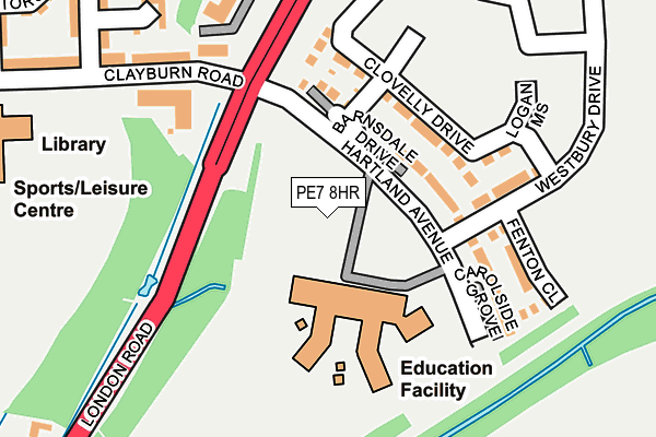
PE7 8HR is located in the Hargate and Hempsted electoral ward, within the unitary authority of Peterborough and the English Parliamentary constituency of North West Cambridgeshire. The Sub Integrated Care Board (ICB) Location is NHS Cambridgeshire and Peterborough ICB - 06H and the police force is Cambridgeshire. This postcode has been in use since February 2017.


GetTheData
Source: OS OpenMap – Local (Ordnance Survey)
Source: OS VectorMap District (Ordnance Survey)
Licence: Open Government Licence (requires attribution)
| Easting | 518313 |
| Northing | 294290 |
| Latitude | 52.533652 |
| Longitude | -0.257171 |
GetTheData
Source: Open Postcode Geo
Licence: Open Government Licence
| Country | England |
| Postcode District | PE7 |
➜ See where PE7 is on a map ➜ Where is Peterborough? | |
GetTheData
Source: Land Registry Price Paid Data
Licence: Open Government Licence
| Ward | Hargate And Hempsted |
| Constituency | North West Cambridgeshire |
GetTheData
Source: ONS Postcode Database
Licence: Open Government Licence
| Hampton College (Clayburn Road) | Hampton | 639m |
| Hampton College (Clayburn Road) | Hampton | 645m |
| Hempsted Road (Eagle Way) | Hampton Vale | 744m |
| Eagle Way | Hampton Vale | 747m |
| Hempsted Road (Eagle Way) | Hampton Vale | 756m |
| Peterborough Station | 4.6km |
GetTheData
Source: NaPTAN
Licence: Open Government Licence
GetTheData
Source: ONS Postcode Database
Licence: Open Government Licence


➜ Get more ratings from the Food Standards Agency
GetTheData
Source: Food Standards Agency
Licence: FSA terms & conditions
| Last Collection | |||
|---|---|---|---|
| Location | Mon-Fri | Sat | Distance |
| Silver Hill | 18:00 | 12:30 | 1,054m |
| New Shopping Centre | 18:00 | 12:30 | 1,163m |
| Westlake Avenue | 18:00 | 12:30 | 1,244m |
GetTheData
Source: Dracos
Licence: Creative Commons Attribution-ShareAlike
| Risk of PE7 8HR flooding from rivers and sea | Medium |
| ➜ PE7 8HR flood map | |
GetTheData
Source: Open Flood Risk by Postcode
Licence: Open Government Licence
The below table lists the International Territorial Level (ITL) codes (formerly Nomenclature of Territorial Units for Statistics (NUTS) codes) and Local Administrative Units (LAU) codes for PE7 8HR:
| ITL 1 Code | Name |
|---|---|
| TLH | East |
| ITL 2 Code | Name |
| TLH1 | East Anglia |
| ITL 3 Code | Name |
| TLH11 | Peterborough |
| LAU 1 Code | Name |
| E06000031 | Peterborough |
GetTheData
Source: ONS Postcode Directory
Licence: Open Government Licence
The below table lists the Census Output Area (OA), Lower Layer Super Output Area (LSOA), and Middle Layer Super Output Area (MSOA) for PE7 8HR:
| Code | Name | |
|---|---|---|
| OA | E00171322 | |
| LSOA | E01033176 | Peterborough 023C |
| MSOA | E02006878 | Peterborough 023 |
GetTheData
Source: ONS Postcode Directory
Licence: Open Government Licence
| PE7 8LL | The Ridge | 380m |
| PE7 8GL | Clayburn Road | 384m |
| PE7 8GH | Harn Road | 386m |
| PE7 8GG | Torold Drive | 409m |
| PE7 8GJ | Delves Way | 413m |
| PE7 8GP | Bank Avenue | 466m |
| PE7 8GN | Brickstead Road | 508m |
| PE7 8GS | Eagle Way | 617m |
| PE7 8LG | Horseshoe Way | 633m |
| PE7 8NU | Teasel Way | 650m |
GetTheData
Source: Open Postcode Geo; Land Registry Price Paid Data
Licence: Open Government Licence