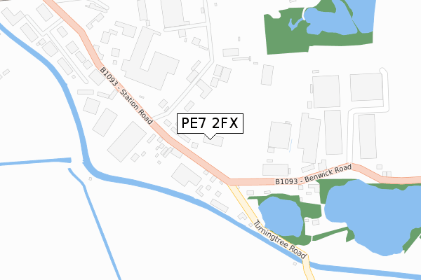
PE7 2FX is located in the Whittlesey South electoral ward, within the local authority district of Fenland and the English Parliamentary constituency of North East Cambridgeshire. The Sub Integrated Care Board (ICB) Location is NHS Cambridgeshire and Peterborough ICB - 06H and the police force is Cambridgeshire. This postcode has been in use since May 2018.


GetTheData
Source: OS Open Zoomstack (Ordnance Survey)
Licence: Open Government Licence (requires attribution)
Attribution: Contains OS data © Crown copyright and database right 2025
Source: Open Postcode Geo
Licence: Open Government Licence (requires attribution)
Attribution: Contains OS data © Crown copyright and database right 2025; Contains Royal Mail data © Royal Mail copyright and database right 2025; Source: Office for National Statistics licensed under the Open Government Licence v.3.0
| Easting | 527998 |
| Northing | 295941 |
| Latitude | 52.546299 |
| Longitude | -0.113831 |
GetTheData
Source: Open Postcode Geo
Licence: Open Government Licence
| Country | England |
| Postcode District | PE7 |
➜ See where PE7 is on a map ➜ Where is Whittlesey? | |
GetTheData
Source: Land Registry Price Paid Data
Licence: Open Government Licence
| Ward | Whittlesey South |
| Constituency | North East Cambridgeshire |
GetTheData
Source: ONS Postcode Database
Licence: Open Government Licence
| New Road (Bellman's Road) | Whittlesey | 875m |
| Bellman's Grove (Bellman's Road) | Whittlesey | 1,132m |
| Coronation Avenue (Eastrea Road) | Whittlesey | 1,183m |
| Coronation Avenue (Eastrea Road) | Whittlesey | 1,193m |
| Victory Avenue | Whittlesey | 1,217m |
| Whittlesea Station | 0.5km |
GetTheData
Source: NaPTAN
Licence: Open Government Licence
GetTheData
Source: ONS Postcode Database
Licence: Open Government Licence


➜ Get more ratings from the Food Standards Agency
GetTheData
Source: Food Standards Agency
Licence: FSA terms & conditions
| Last Collection | |||
|---|---|---|---|
| Location | Mon-Fri | Sat | Distance |
| Hawthorne Drive | 17:30 | 11:30 | 917m |
| Station Road | 17:30 | 11:30 | 1,076m |
| Coronation Avenue | 17:30 | 11:30 | 1,195m |
GetTheData
Source: Dracos
Licence: Creative Commons Attribution-ShareAlike
The below table lists the International Territorial Level (ITL) codes (formerly Nomenclature of Territorial Units for Statistics (NUTS) codes) and Local Administrative Units (LAU) codes for PE7 2FX:
| ITL 1 Code | Name |
|---|---|
| TLH | East |
| ITL 2 Code | Name |
| TLH1 | East Anglia |
| ITL 3 Code | Name |
| TLH12 | Cambridgeshire CC |
| LAU 1 Code | Name |
| E07000010 | Fenland |
GetTheData
Source: ONS Postcode Directory
Licence: Open Government Licence
The below table lists the Census Output Area (OA), Lower Layer Super Output Area (LSOA), and Middle Layer Super Output Area (MSOA) for PE7 2FX:
| Code | Name | |
|---|---|---|
| OA | E00091107 | |
| LSOA | E01018059 | Fenland 008B |
| MSOA | E02003749 | Fenland 008 |
GetTheData
Source: ONS Postcode Directory
Licence: Open Government Licence
| PE7 2HA | Station Road | 143m |
| PE7 2JA | Lattersey Hill Trading Estate | 271m |
| PE7 2HB | Turningtree Road | 433m |
| PE7 2EY | Station Road | 459m |
| PE7 1UL | Mulberry Close | 615m |
| PE7 1UQ | Marne Road | 646m |
| PE7 1SZ | New Road | 646m |
| PE7 1TR | Sycamore Road | 663m |
| PE7 2HD | Benwick Road | 700m |
| PE7 1TL | Sycamore Road | 703m |
GetTheData
Source: Open Postcode Geo; Land Registry Price Paid Data
Licence: Open Government Licence