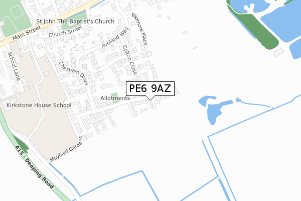
PE6 9AZ is located in the Casewick electoral ward, within the local authority district of South Kesteven and the English Parliamentary constituency of Grantham and Stamford. The Sub Integrated Care Board (ICB) Location is NHS Lincolnshire ICB - 71E and the police force is Lincolnshire. This postcode has been in use since September 2018.


GetTheData
Source: OS Open Zoomstack (Ordnance Survey)
Licence: Open Government Licence (requires attribution)
Attribution: Contains OS data © Crown copyright and database right 2025
Source: Open Postcode Geo
Licence: Open Government Licence (requires attribution)
Attribution: Contains OS data © Crown copyright and database right 2025; Contains Royal Mail data © Royal Mail copyright and database right 2025; Source: Office for National Statistics licensed under the Open Government Licence v.3.0
| Easting | 511640 |
| Northing | 313725 |
| Latitude | 52.709704 |
| Longitude | -0.348949 |
GetTheData
Source: Open Postcode Geo
Licence: Open Government Licence
| Country | England |
| Postcode District | PE6 |
➜ See where PE6 is on a map ➜ Where is Baston? | |
GetTheData
Source: Land Registry Price Paid Data
Licence: Open Government Licence
| Ward | Casewick |
| Constituency | Grantham And Stamford |
GetTheData
Source: ONS Postcode Database
Licence: Open Government Licence
2021 4 MAR £215,000 |
26, STARSMORE FIELDS, BASTON, PETERBOROUGH, PE6 9AZ 2020 5 AUG £214,995 |
6, STARSMORE FIELDS, BASTON, PETERBOROUGH, PE6 9AZ 2020 10 JUL £214,695 |
8, STARSMORE FIELDS, BASTON, PETERBOROUGH, PE6 9AZ 2020 1 JUL £203,215 |
27, STARSMORE FIELDS, BASTON, PETERBOROUGH, PE6 9AZ 2020 8 MAY £237,995 |
17, STARSMORE FIELDS, BASTON, PETERBOROUGH, PE6 9AZ 2020 6 MAY £224,995 |
19, STARSMORE FIELDS, BASTON, PETERBOROUGH, PE6 9AZ 2019 30 DEC £255,995 |
25, STARSMORE FIELDS, BASTON, PETERBOROUGH, PE6 9AZ 2019 20 DEC £253,995 |
30, STARSMORE FIELDS, BASTON, PETERBOROUGH, PE6 9AZ 2019 29 NOV £241,995 |
24, STARSMORE FIELDS, BASTON, PETERBOROUGH, PE6 9AZ 2019 14 OCT £248,995 |
GetTheData
Source: HM Land Registry Price Paid Data
Licence: Contains HM Land Registry data © Crown copyright and database right 2025. This data is licensed under the Open Government Licence v3.0.
| St John The Baptist's Church (Main Street) | Baston | 388m |
| Demand Responsive Area | Baston | 389m |
| St John The Baptist's Church (Main Street) | Baston | 400m |
| High Street (A15) | Baston | 591m |
| High Street (A15) | Baston | 607m |
GetTheData
Source: NaPTAN
Licence: Open Government Licence
| Percentage of properties with Next Generation Access | 100.0% |
| Percentage of properties with Superfast Broadband | 100.0% |
| Percentage of properties with Ultrafast Broadband | 100.0% |
| Percentage of properties with Full Fibre Broadband | 100.0% |
Superfast Broadband is between 30Mbps and 300Mbps
Ultrafast Broadband is > 300Mbps
| Percentage of properties unable to receive 2Mbps | 0.0% |
| Percentage of properties unable to receive 5Mbps | 0.0% |
| Percentage of properties unable to receive 10Mbps | 0.0% |
| Percentage of properties unable to receive 30Mbps | 0.0% |
GetTheData
Source: Ofcom
Licence: Ofcom Terms of Use (requires attribution)
GetTheData
Source: ONS Postcode Database
Licence: Open Government Licence


➜ Get more ratings from the Food Standards Agency
GetTheData
Source: Food Standards Agency
Licence: FSA terms & conditions
| Last Collection | |||
|---|---|---|---|
| Location | Mon-Fri | Sat | Distance |
| Baston Post Office | 16:30 | 11:45 | 422m |
| Baston Village | 16:20 | 09:30 | 610m |
| New Road | 16:00 | 09:30 | 1,331m |
GetTheData
Source: Dracos
Licence: Creative Commons Attribution-ShareAlike
The below table lists the International Territorial Level (ITL) codes (formerly Nomenclature of Territorial Units for Statistics (NUTS) codes) and Local Administrative Units (LAU) codes for PE6 9AZ:
| ITL 1 Code | Name |
|---|---|
| TLF | East Midlands (England) |
| ITL 2 Code | Name |
| TLF3 | Lincolnshire |
| ITL 3 Code | Name |
| TLF30 | Lincolnshire CC |
| LAU 1 Code | Name |
| E07000141 | South Kesteven |
GetTheData
Source: ONS Postcode Directory
Licence: Open Government Licence
The below table lists the Census Output Area (OA), Lower Layer Super Output Area (LSOA), and Middle Layer Super Output Area (MSOA) for PE6 9AZ:
| Code | Name | |
|---|---|---|
| OA | E00133914 | |
| LSOA | E01026364 | South Kesteven 012E |
| MSOA | E02005487 | South Kesteven 012 |
GetTheData
Source: ONS Postcode Directory
Licence: Open Government Licence
| PE6 9QH | Colton Close | 119m |
| PE6 9QL | Denshire Court | 170m |
| PE6 9RN | Padmore Place | 193m |
| PE6 9AX | Mayfield Gardens | 204m |
| PE6 9QJ | Aveland Way | 259m |
| PE6 9QW | Chesham Drive | 269m |
| PE6 9PE | Church Street | 348m |
| PE6 9AQ | Rous Court | 350m |
| PE6 9PJ | Cardyke Drive | 400m |
| PE6 9PA | Main Street | 448m |
GetTheData
Source: Open Postcode Geo; Land Registry Price Paid Data
Licence: Open Government Licence